Tropical Storm Laura (2008) facts for kids
| Tropical Storm (SSHWS/NWS) | |

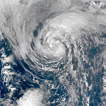
Tropical Storm Laura on September 30, 2008.
|
|
| Formed | September 29, 2008 |
|---|---|
| Dissipated | October 1, 2008 |
| Highest winds | 1-minute sustained: 60 mph (95 km/h) |
| Lowest pressure | 994 mbar (hPa); 29.35 inHg |
| Fatalities | None |
| Damage | None |
| Areas affected | Netherlands, British Isles, Norway (when post-tropical) |
| Part of the 2008 Atlantic hurricane season | |
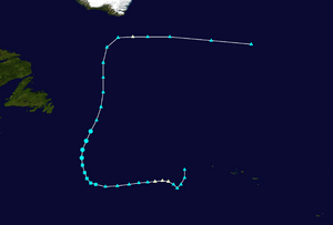
Tropical Storm Laura was the twelfth named storm of the 2008 Atlantic hurricane season. Laura started as a big non-tropical low pressure area. It formed about 1,015 miles (1,635 km) west of the Azores islands on September 29, 2008. Laura slowly gained tropical features as it moved over warmer ocean waters.
By the afternoon of September 30, Laura had enough tropical features to be called a "Tropical Storm." Soon after becoming a tropical storm, Laura began to change into an extratropical storm. This change finished by the morning of October 1. Laura then became a post-tropical cyclone. The National Hurricane Center then stopped giving updates on the storm.
Contents
How Tropical Storm Laura Formed
In late September 2008, a large weather system formed over the north-central Atlantic Ocean. This system was not tropical at first. It slowly moved west, away from the Azores. The system had strong winds, but it did not look like a tropical cyclone.
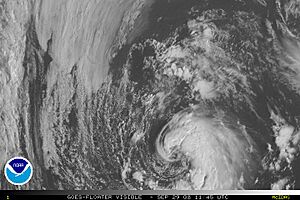
Over the next few days, the storm became weaker. However, it started to gain tropical features as it moved over slightly warmer water. By September 29, the low pressure area had enough thunderstorms. It was then called Subtropical Storm Laura.
Laura's Change to a Tropical Storm
When Laura became a subtropical storm, cold cloud tops started to form around its center. These clouds gathered near the middle of the storm. The thunderstorms quickly organized around the center. A satellite pass showed that the storm might be getting stronger. However, another satellite pass later confirmed its winds were about 60 mph (95 km/h).
Laura's overall structure was still subtropical. But there were signs it was becoming more like a tropical storm. In the afternoon, satellites showed that Laura had a deep warm core. This is a key feature of a tropical cyclone. However, its wind pattern was still like a subtropical storm.
By night, the strongest winds were only about 80 miles (130 km) from the center. This area was much smaller than a typical subtropical cyclone. Still, Laura was affected by an upper-level low pressure area. Its cloud tops remained shallow. But the cloud tops became colder overnight. By the morning of September 30, Laura was almost a tropical cyclone. However, it was still strongly connected to the upper-level low.
Even though Laura was moving over colder water, a satellite image showed something important. Laura had separated from the upper-level low. This meant it had become a true tropical cyclone. Laura was upgraded to a tropical storm at a high latitude, which is 41.2°N.
Laura Becomes a Post-Tropical Cyclone
Soon after becoming a tropical storm, Laura started to change again. Cold air began to enter the storm from the west. Weather models showed Laura would become extratropical the next morning. It would then become non-tropical later that day.
Overnight, the thunderstorms with Laura started to fade. The storm began to lose its tropical features. But it was still called a tropical storm. Early on October 1, the change to an extratropical cyclone was clear. Laura was still tropical, but its cloud pattern was becoming more like a weather front. There were few thunderstorms around the center.
Laura later changed into a post-tropical cyclone. This term means a storm has lost its tropical features. But it is not subtropical or extratropical. The Canadian Hurricane Centre had used this term before. The change was expected to be complete by the end of the day.
Laura's Impact on Land
While Laura was a tropical cyclone, it never came close to land. So, it caused no damage and no one was hurt. But, the storm's leftover parts were caught in a strong upper-level jet stream. This pushed them towards Europe.
Heavy rain fell across parts of Britain. This caused local flooding. For example, Glebe Road near Windermere, England, had to close. Along the A65 road between Old Hutton and Kirkby Lonsdale, the ground was already wet. The storm drains could not handle all the rain. This led to local flooding. Traffic on the M6 Motorway also slowed down because of bad driving conditions.
After the remains of Laura, now an extratropical storm, reached the southern coast of the Netherlands, its rain clouds mixed with a cold front. This front was linked to a strong low pressure system west of Norway. Up to 4.5 inches (113 mm) of rain fell in the northwestern Netherlands. This flooded streets and homes in the village of Hippolytushoef. More than 10,000 people in southern Norway lost electricity. This happened because the storm's remains damaged the electrical system.
Related Information
- NHC's Archive on Laura
 | Misty Copeland |
 | Raven Wilkinson |
 | Debra Austin |
 | Aesha Ash |


