Truro, South Australia facts for kids
Quick facts for kids TruroSouth Australia |
|||||||||||||||
|---|---|---|---|---|---|---|---|---|---|---|---|---|---|---|---|

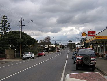
The Sturt Highway, the main street of Truro, (looking west towards the Barossa Valley and Adelaide)
|
|||||||||||||||
| Population | 523 (2021 census) | ||||||||||||||
| Established | 1847 (town) 16 March 2000 (locality) |
||||||||||||||
| Postcode(s) | 5356 | ||||||||||||||
| Location | |||||||||||||||
| LGA(s) |
|
||||||||||||||
| State electorate(s) | Stuart | ||||||||||||||
| Federal Division(s) | Barker | ||||||||||||||
|
|||||||||||||||
Truro is a small town in South Australia. It's about 80 kilometers (50 miles) northeast of Adelaide, the state capital. The town is located on the Sturt Highway, which is a major road.
Truro is in an area known for farming and raising animals like sheep. It sits east of the famous Barossa Valley, in the hilly Mount Lofty Ranges. In 2021, about 523 people lived in Truro.
The town is part of the Mid Murray Council, which is a local government area. This council helps manage services for the community. Truro is also represented by politicians in both the state and national governments.
Contents
History of Truro
Truro was officially started in 1848. It was founded by John Howard Angas, whose father, George Fife Angas, had bought the land earlier in 1842. The town was built near Truro Creek, also known as White Hut Creek.
How Did Truro Get Its Name?
The town is named after the city of Truro in Cornwall, United Kingdom. It's not completely clear if John Howard Angas chose the name, or if the first people who settled there did. However, many early settlers were Cornish miners. There was a copper mine nearby called Wheal Barton. Because of these miners, it's very likely they inspired the town's name, even if they didn't name it themselves. Another small settlement called Barton was also nearby, but it soon became part of Truro.
Truro's Local Government
For many years, Truro had its own local government called the District Council of Truro. This council managed the town from 1876 until 1991. After that, it became part of a larger council area.
Historic Places in Truro
Truro has several places that are important because of their history. These are called heritage-listed sites, meaning they are protected to preserve their past.
- Baldon Road: The Baldon Homestead Complex
- 37 Moorundie Street: The old Truro Police Station and Cells
- off Sturt Highway: A historic Stone Wall
- off Sturt Highway: Accommodation Hill Spring and Pipeline Relics
What Industries Are in Truro?
From the early 1840s, the first main industry brought to the Truro area by European settlers was pastoralism. This means raising animals, mostly sheep. Shepherds looked after large flocks of sheep on open land. Many of the old stone walls you can see in the area today were built during this time to help manage the sheep.
Mining for Copper
Copper was found in the area in 1846. A mine called Wheal Barton opened about 2 kilometers (1.2 miles) east of Truro. Copper was mined there from 1849 to 1889, and again from 1956 to 1972. The discovery of these copper mines was a big reason why the town of Truro was planned and built. The mine started in 1849, and a church was built in the town by August 1850.
Railways and Farming
Truro was once the end point of the Truro railway line. This railway opened in 1917 and helped transport goods and people. However, it stopped running in the 1970s and was permanently closed in the 1980s.
Truro gets less rain than the nearby Barossa Valley. Because of this, farmers in Truro mostly grow dry grain crops like wheat and barley. Growing grapes for wine, which is common in the Barossa Valley, is less common here.
Tourism and Services
Today, Truro has two hotels. It also offers a few things for tourists, like Pioneer Park, a special shop that sells olive products, and several antique shops. The town also provides services like fuel and food for people traveling along the Sturt Highway.
 | Misty Copeland |
 | Raven Wilkinson |
 | Debra Austin |
 | Aesha Ash |


