Tubbs Hill facts for kids
Quick facts for kids Tubbs Hill |
|
|---|---|
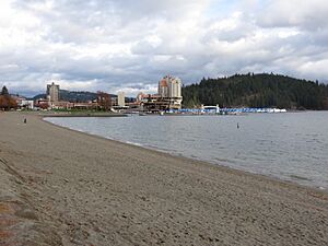
Tubbs Hill from City Beach
|
|
| Type | Urban park |
| Location | Coeur d'Alene, Idaho, U.S. |
| Area | 165 acres (0.67 km2) |
| Operated by | Friends of Tubbs Hill |
| Visitors | about 150,000 annually |
| Status | Open year round (daily, 5 am to 11 pm) |
| Website | TubbsHill.org |
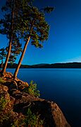
The Tubbs Hill Natural Area is a large public park. It covers about 165 acres (0.67 km2) in Coeur d'Alene, Idaho. This park is on a peninsula. Lake Coeur d'Alene surrounds it on three sides. McEuen Park is to the north.
You can find the main entrance at 210 South 3rd Street. Another entrance is at the end of 10th Street. The most popular part is the Interpretive Trail. This trail is about 2.2 miles (3.5 km) long. It takes you past amazing views and historical spots. Most people finish it in about 52 minutes.
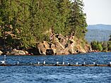
Many fun activities happen here. You can go climbing, cliff jumping, or kayaking. Fishing, sunbathing, and bird watching are also popular. You can even enjoy flower viewing when plants are blooming.
The hill is mostly solid rock. It has a thin layer of topsoil, usually less than 5 inches (13 cm) deep. Even with shallow soil, many plants grow here. You will see lots of ponderosa pine and Douglas fir trees. Tubbs Hill is a managed forest. Groups like the Tubbs Hill Foundation help take care of it.
You can bring your dog if it's on a leash. But some things are not allowed. These include bicycles, motor vehicles, alcohol, glass bottles, smoking, campfires, and fireworks.
Contents
Exploring Tubbs Hill: Nature and Wildlife
Tubbs Hill is a 165-acre (0.67 km2) park. It sits on a peninsula in Coeur d'Alene, Idaho. Lake Coeur d'Alene borders the park on its west, south, and east sides. The park has two entrances. One is at 210 South 3rd Street, next to McEuen Park. The other is at the south end of 10th Street. The hill reaches 2,128 feet (649 m) above sea level at the water. Its highest point is 2,503 feet (763 m) high.
How the Land Was Formed
The lake and rocks here were shaped by the Missoula floods. These huge floods happened about 15,000 years ago. A large glacier melted and broke apart. This caused massive floods from Glacial Lake Missoula. The floodwaters pushed rock and dirt across the valleys.
The hill's rock is mostly schist and gneiss. These are metamorphic rocks. They formed when heat from rising magma changed old sediments. The soil is mostly volcanic ash. This ash came from Mount Mazama about 6,500 years ago. Wind and decaying plants also add to the soil. The soil is very thin, usually less than 5 inches (13 cm) deep. You might even find shiny flakes of mica, sometimes called "fool's gold," in the streams.
Trees and Plants
The most common trees on Tubbs Hill are ponderosa pine and Douglas fir. You can also find grand fir, western larch, and western white pine. Ponderosa pines grow well on sunny, windy slopes. Douglas firs prefer wetter, shadier areas. This means different parts of the park look very different.
Drier areas have open, grassy spaces. Wetter areas are thick with plants. You can find shrubs like kinnikinnick and ocean spray. Other shrubs include thimbleberry and Oregon grape. Many types of ferns, lichens, and mosses also grow here.
Caring for the Forest
Tubbs Hill is a managed forest. It's too small to stay healthy on its own. So, groups like the Tubbs Hill Foundation help maintain it. The thin soil makes the ecosystem fragile. Plants struggle to survive. Rain can easily wash away the topsoil, causing erosion. Plant roots help hold the soil in place. That's why it's important to stay on marked trails. Avoid stepping on plants. Remember to "take only photographs, leave only footprints."
Crews also remove dead trees. This helps prevent bug problems like the Douglas Fir bark beetle. It also stops root rot. They also plant new trees to keep the forest diverse. These are things wildfires would naturally do in a larger forest.
Animals You Might See
You can spot several animals in the park. White-tailed deer and turkey are common. Osprey and bald eagles also live here. These birds of prey often build nests in dead trees near the lake. They hunt for fish in the water.
Park Features and Activities
Tubbs Hill offers beaches for lake access. It has a 2.2-mile (3.5 km) interpretive trail. There are also many spots with amazing views of Lake Coeur d'Alene. Popular activities include climbing, cliff jumping, and kayaking. You can also go fishing, sunbathing, and bird watching. Enjoying the flowers is another favorite pastime.
The Interpretive Trail
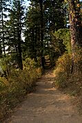
The main attraction is the interpretive trail loop. It can get busy from May to October. The trail is mostly dirt and narrow. It's rated as "easy" to walk. The first mile (1.6 km) is mostly flat. You might find some rocks and tree roots. The trail is not good for wheelchairs or strollers.
The hike gains about 291 feet (89 m) in height. It usually takes about 52 minutes to complete. This self-guided trail shows you scenic views and historical places. Wooden markers, 8 by 10 inches (20 by 25 cm) in size, guide you. They are posted 8 feet (2.4 m) above the ground. At the entrance, you can find a map and brochure. These match the markers.
There are also side trails. These let you shorten the main loop. Or you can use them to hike up to the top of Tubbs Hill.
Other Features
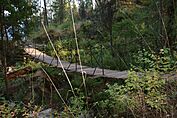
The park has several bridges. One famous one is a rope suspension bridge. You'll also see memorial stones and plaques. These honor local wildlife advocates, Art Manley and Scott Reed. They are near the main trail entrance.
History of Tubbs Hill
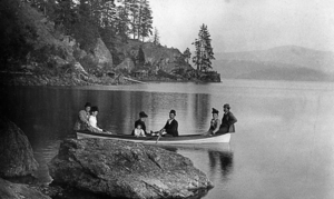
The land that is now Tubbs Hill once belonged to the Coeur d'Alene Tribe. This was part of their huge 4-million-acre (16,000 km2) territory.
After Coeur d'Alene became a city, a man named Tony A. Tubbs bought land. In 1884, he planned a development called "Tubbs Hill Addition." It was over 130 acres (0.53 km2). Tubbs was a well-liked person in the community. He built the city's first hotel and became the first Justice of the Peace.
Tubbs planned straight streets for his development. But he didn't consider the steep hillside. Land salesmen often sold undeveloped land by saying it was flat. This was for settlers who bought property without seeing it. But Tubbs Hill was not easy to build on. It was almost solid rock. The hill rose over 375 feet (114 m) from its base to its peak. Its slope varied from 8 to 30 degrees.
Tubbs didn't have much luck selling the land. In 1903, the Washington Water Power Co. bought parts of the hill. They built concrete reservoirs to store lake water. Another reservoir was built in 1949. The Coeur d'Alene Lumber Company bought waterfront land. They built a sawmill there. But it closed during the Great Depression.
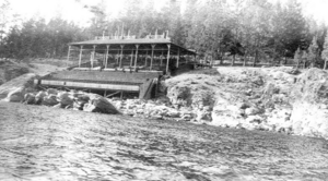
A grandstand was built in the 1920s. People watched sailboat races and hydroplane races from there. During World War II, the Farragut Naval Training Station built housing and a civic center. These were later taken down.
Over the years, there were plans for other buildings. These included power plants and a convention center. In 1973, some German investors wanted to build condos. But the city was able to buy the property in 1974. The difficult land made development hard.
The City of Coeur d'Alene bought Tubbs Hill in four steps. The first purchase was 33 acres (0.13 km2) in 1936. This land now includes McEuen Park and City Hall. The city bought three more 34-acre (0.14 km2) sections in 1969, 1974, and 1977.
Historical Spots on the Interpretive Trail
You can still see some historical sites on the interpretive trail. About halfway, at the 1-mile (1.6 km) mark, you'll find concrete foundations. These are from a grandstand built in 1914. People used it to watch boat races and Independence Day events.
At the 2-mile (3.2 km) mark, you'll see more concrete foundations. These are from the Coeur d'Alene Mill Company. This sawmill operated on the site until 1929.
 | Victor J. Glover |
 | Yvonne Cagle |
 | Jeanette Epps |
 | Bernard A. Harris Jr. |


