Twelve-Mile Circle facts for kids

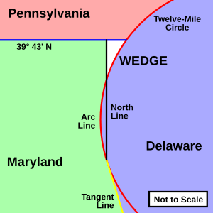
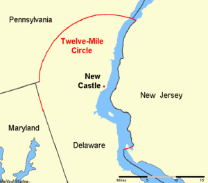
The Twelve-Mile Circle is a special border that looks like a big, nearly round line. It forms most of the boundary between Pennsylvania and Delaware in the United States. Even though it's called a "circle," it's actually made of several curved lines joined together smoothly.
This unique border is supposed to be a circle with a radius of about 12 miles. Its center point is in the town of New Castle, Delaware. In 1750, this center was officially set at the courthouse in New Castle. The Twelve-Mile Circle even extends into the Delaware River.
A small part of this circle, called the "Arc Line," is also part of the famous Mason–Dixon line. This line separates Delaware from Maryland. Two other small sections of the circle also form parts of the border between Delaware and New Jersey. These parts were officially marked in 1934.
Contents
How the Circle Began
The story of the Twelve-Mile Circle goes back to 1681. At that time, King Charles II gave land to William Penn. This land was north of the already established Maryland colony.
However, King Charles made an exception. He set aside a 12-mile area around the town of New Castle. This land belonged to the Duke of York. The Duke had won it from Dutch settlers.
Later, on August 24, 1682, the Duke of York also gave this special land to William Penn. The official document said Penn would get:
All that the Towne of Newcastle otherwise called Delaware and the fort therein or thereunto belonging scituate lying and being between Maryland and New Jersey in America. And all that Tract of land lying within the Compasse or Circle of twelve miles about the said Towne Scituate lying and being upon the River Delaware and all islands in the said River of Delaware and the said River and Soyle thereof lying North of the Southernmost part of the said Circle of twelve miles about the said Towne. And all that Tract of Land upon Delaware River and Bay beginning twelve miles South from the said Towne of Newcastle otherwise called Delaware and extending South to Cape Lopen [Henlopen].
This circle became a very important part of a long argument. It was central to the eighty-year Penn–Calvert boundary dispute over land borders.
Delaware River Border
The fact that the Twelve-Mile Circle extends into the Delaware River makes it a very unusual border. Most borders that follow rivers split the river between two areas. This is usually done by finding the middle line of the river. Or, it's done by finding the deepest part of the main flow channel, called the thalweg.
But because of the old land document, all of the Delaware River within the Twelve-Mile Circle belongs to Delaware. This includes the river up to the low-tide mark on the New Jersey side. This means Delaware owns the river and its islands in this area. A similar situation exists between Vermont and New Hampshire on the Connecticut River.
New Jersey has often disagreed with Delaware about this claim. This is because most of New Jersey's other borders along the Delaware River use the middle line method.
Pea Patch Island Dispute
In 1813, Delaware's government passed a law to give Pea Patch Island to the United States government. Pea Patch Island is in the Delaware River. In 1820, New Jersey argued that they owned the island. They said it was mostly on their side of the river.
The Attorney General, William Wirt, agreed with Delaware. In the 1840s, the disagreement over Pea Patch Island led to two different court decisions. One court in Delaware said the whole river belonged to Delaware. Another court in New Jersey said the island belonged to New Jersey.
To solve the problem, President James K. Polk suggested that both sides agree to let someone else decide. This process is called arbitration. The arbitration confirmed that Delaware's claim was correct.
Ongoing Border Arguments
Even after the arbitration, the argument didn't completely stop. The issue has been brought to the Supreme Court of the United States many times. These cases were all called New Jersey v. Delaware.
The Supreme Court even told New Jersey and Delaware in 1935 to stop arguing about their borders. But the states were back in court as late as 2005. This happened when New Jersey wanted to approve plans for a natural gas terminal. This terminal would be built along the New Jersey side of the Delaware River. But Delaware's laws, specifically its Coastal Zone Act, got in the way.
In 2006, the court appointed a special expert to study the border dispute. In 2008, the court agreed with the expert's report. This report mostly supported Delaware's authority over the river in that area. During this time, some lawmakers in Delaware even thought about calling out the United States National Guard to protect their state's interests. New Jersey lawmakers joked about the battleship New Jersey being nearby.
Surveying the Circle
There are stories that David Rittenhouse, a famous astronomer from Pennsylvania, helped map the circle around New Castle. However, this is probably not true. The circle was first measured by surveyors named Taylor and Pierson in 1701.
A book from 1813 about David Rittenhouse suggested he was involved in a survey in 1763. This was based on a letter where Rittenhouse mentioned being paid "for my attendance at New Castle." But there is no clear record of what he was paid for. One of his biographers thought Rittenhouse might have helped with calculations for latitude or longitude.
 | Emma Amos |
 | Edward Mitchell Bannister |
 | Larry D. Alexander |
 | Ernie Barnes |


