Penn–Calvert boundary dispute facts for kids
The Penn–Calvert boundary dispute was a long argument between two important families in early America: William Penn and his family, and Charles Calvert, 3rd Baron Baltimore and his family. They both had special papers (called charters) from the King of England that gave them land in America. The problem was, their land descriptions overlapped! This caused many disagreements and required the King and courts in England to step in and help fix it. Even later, American courts and the Supreme Court of the United States had to deal with questions about these borders. This dispute helped create the final shapes of five U.S. states: Pennsylvania, Maryland, Delaware, New Jersey, and West Virginia.
Contents
How the Problem Started
In 1629, some Dutch traders bought land near what is now Lewes, Delaware, from the Nanticoke people. They started a small colony called Zwaanendael in 1631. But this colony didn't last long; it was wiped out by conflicts with the Nanticoke tribe within a year.
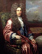
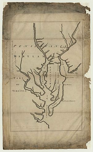
In 1632, King Charles I gave Cecil Calvert, 2nd Baron Baltimore a special paper, a charter, for land around the Chesapeake Bay. This charter said Maryland's northern border was the 40th parallel (a line of latitude), and its eastern border was the Delaware Bay and the Atlantic Ocean. However, the charter only gave the Calverts land that was "uncultivated" (not settled by Europeans). When colonists arrived in Maryland in 1634, they didn't try to survey the northern border or settle near Delaware Bay.
Later, in 1638, the colony of New Sweden was started north of Delaware Bay, near what is now Wilmington, Delaware. The Dutch saw this as an invasion of their territory. So, in 1651, the Dutch built a new outpost called Fort Casimir near what is now New Castle, Delaware. The Swedes took over Fort Casimir in 1654, but the Dutch leader, Peter Stuyvesant, quickly took it back and also conquered New Sweden's main fort in 1655. The Dutch renamed Fort Casimir to New Amstel.
The English didn't like the Swedish or Dutch colonies. In 1659, Maryland complained to the Dutch that they were on Lord Baltimore's land. Then, in 1664, King Charles II gave his brother, James, the Duke of York, all the land between the Connecticut and Delaware Rivers. The English quickly took over the Dutch colonies, including those along Delaware Bay. New Amstel was renamed New Castle.
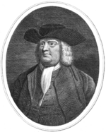
In 1681, William Penn received his own charter for Pennsylvania from King Charles II. Lord Baltimore (now Charles Calvert, Cecil's son) didn't object, as long as Penn's land was north of Maryland's 40th parallel border. Also, the Duke of York kept the lands around New Castle that he had won. King Charles II created a Twelve-Mile Circle around New Castle for the Duke. Penn wanted access to the ocean for his colony, so he convinced James to lease these lands to him. In 1682, the Duke of York gave Penn the Twelve Mile Circle around New Castle and the lands south of it, down to Cape Henlopen.
Penn sailed to the colonies and met with Calvert in New Castle in May 1683. The two men couldn't agree on how to draw the borders, including where Pennsylvania's southern border should be and how to measure the Twelve Mile Circle. This meeting was the start of their long legal fight.
The Long Border Fight Begins
William Penn wanted his new colony to reach the Chesapeake Bay. But Calvert insisted that Maryland's northern border was the 40th parallel. He also believed that the lands on the Delaware Bay were part of Maryland's original 1632 charter. Since they couldn't agree, Penn decided to take the case to court in England. Both Penn and Calvert went back to England for the case.
At this time, the Duke of York had become King James II. Penn thought he had a good chance because he and James were friends. Penn argued that Maryland's charter was only for "uncultivated" lands. He pointed out that the Dutch had already settled the area near Delaware Bay with the Zwaanendael Colony before Maryland's charter. This argument had also been made by the Dutch themselves earlier. This point turned out to be very important.
The Committee for Trade and Plantations (a group that advised the King) agreed that Baltimore's charter was only for land that hadn't been settled by Europeans. Since Christians had lived in the disputed area before and after Maryland was settled, it couldn't belong to Baltimore. On November 7, 1685, King James made a decision that was a compromise. He ordered that the land between the Chesapeake and Delaware Bays be split in half. He also kept Maryland's northern border at the 40th parallel. However, Calvert still didn't have the border surveyed. In December 1688, King James gave Penn a new, clearer charter for the Delaware lands.
On July 20, 1701, the people of the Lower Counties (which is now Delaware) asked Penn for their own government. Penn agreed on August 28. He ordered a survey of the Twelve Mile Circle to set the official borders between Pennsylvania and the Lower Counties. Isaac Taylor and Thomas Piersons did this survey in 1701, but they made some mistakes. This was the first official attempt to define the Twelve-Mile Circle, but it wouldn't be the last.
In 1709, Charles Calvert asked Queen Anne to cancel the part of the 1683 ruling that gave Penn land south of the 40th parallel. Penn fought against this, and on June 23, 1710, the Queen dismissed Calvert's request. After the Queen's decision, both the Pennsylvania and Delaware governments accepted the Taylor-Piersons borders. But this didn't stop all the problems on the ground. Maryland continued to give land to its settlers within Delaware's borders, and there were fights between law officers from both areas. Also, the Delaware government changed its mind about the circular borders just one year after approving them.
Charles Calvert, the 3rd Lord Baltimore, died in 1715, and William Penn died in 1718. The dispute was then continued by Calvert's son, Charles Calvert, 5th Baron Baltimore, and Penn's children, John, Thomas, and Richard.
The 1732 Agreement
It was discovered that the Twelve Mile Circle didn't actually touch the 40th parallel, and that the 40th parallel was actually north of Philadelphia, Pennsylvania's main city. This led to more arguments. Both sides secretly tried to survey the borders on their own. In 1722, Calvert complained that a Maryland judge was arrested by Pennsylvania for "running out some lines" in the forest. Maryland, in turn, arrested Isaac Taylor, the surveyor who had worked on the circle before. Fights between settlers, like Cresap's War, and confusion over who to pay taxes to, made both sides want to settle the issue.
In 1731, Calvert asked King George II to make the Penns agree to officially mark the borders. The King and his advisors convinced the two sides to make another compromise. On May 10, 1732, Calvert and the Penns signed an agreement. This agreement confirmed much of the 1685 ruling but changed Pennsylvania's southern border to be below the 40th parallel. The agreement described a complex way to draw the lines, but the map included in the agreement incorrectly labeled Fenwick Island, Delaware as Cape Henlopen. This point was 19 miles south of the actual Cape Henlopen.
The 1732 agreement also created a new group of Commissioners to oversee the drawing of the borders and place monuments. Each side appointed 7 members. The Commissioners met several times but couldn't agree on how to measure the Twelve Mile Circle. Maryland wanted the circle to have a 12-mile circumference, while Pennsylvania wanted a 12-mile radius. Lord Baltimore also found the map error about Fenwick Island and protested it.
Because they couldn't agree, Lord Baltimore filed a new case in the English courts, and the Penns filed one too. King George II then ordered that neither family could give out land in the disputed area for a while, and he set up temporary border lines.
The Court Case and Its Outcome
The arguments from Calvert and the Penns were finally heard by the English Court of Chancery in 1750. After looking at old land papers, agreements, and hearing from both sides, on May 15, 1750, Philip Yorke, 1st Earl of Hardwicke, the main judge, ruled that the 1732 Agreement should be followed. He ordered new Commissioners to be appointed to draw the borders. He also solved the problems that had stopped the first Commissioners. He decided that the center of the circle would be the center of New Castle, the circle would have a 12-mile radius, and Fenwick Island (not Cape Henlopen) would be used as the southern boundary, as agreed in 1732.
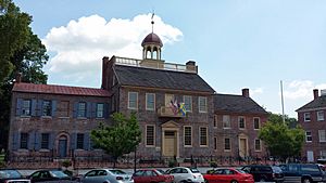
The new Commissioners met in New Castle in November 1750. They agreed that the cupola (the small dome) on top of the New Castle Court House should be the "center" of the Twelve Mile Circle.
The Commissioners then hired a survey team to map the line dividing the northern and southern parts of the peninsula, starting from Fenwick Island and going west. This survey was called the Transpeninsular Line. The team finished this survey by June 1751.
However, the Commissioners still couldn't agree on some things. They disagreed about where the western end of the Transpeninsular Line should be. They also argued about whether the Twelve Mile Circle should be measured on the ground (which would make it smaller due to hills) or on a straight, level line (which would make it a full twelve miles). They sent these questions back to Lord Hardwicke. He ruled that the western point of the Transpeninsular Line should be the Chesapeake Bay. He also approved using the New Castle Court House as the center of the Twelve Mile Circle and said the twelve miles should be measured on a level line.
The Final Solution
In 1751, Charles Calvert died. His son, Frederick Calvert, 6th Baron Baltimore, didn't want to follow his father's agreements. This stopped the border resolution again. But by 1760, Calvert changed his mind and agreed to the terms of the 1732 agreement and the judge's ruling from 1750. In November of that year, the Commissioners met and finally agreed on the Transpeninsular Survey results, placing the Middle Point marker. The southernmost border was finally finished.
In 1761, colonial surveyors tried to survey the Twelve Mile Circle, but their tools and calculations were not good enough. They tried again in 1763, but it was still wrong. The two families agreed to hire a new team from England. A contract was signed on July 20, 1763, with Charles Mason and Jeremiah Dixon. Mason and Dixon arrived in Philadelphia in November 1763.
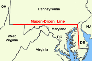
Mason and Dixon's first job was to find the southernmost point of Philadelphia, where they built an observatory. They then went 31 miles west and set up their headquarters, marking a stone that is now known as the Star Gazers' Stone. After more observations, they established the east-west border line between Pennsylvania and Maryland. In August 1764, they drew a line from the New Castle Court House to find the correct tangent point for the circle. From September 4–25, they surveyed the north-south line down to the Middle Point Marker.
In November, Mason and Dixon met with the Commissioners, who approved their results. From December 1765 to January 1766, they placed monument stones along the border. In 1767, they mapped the western line as far as they could. They presented their final borders to the Commissioners in November 1767 and left America in September 1768.
Baltimore and the Penns asked King George III to approve the Mason-Dixon borders on August 20, 1768. King George approved the borders on January 11, 1769. This was more than 85 years after the dispute began! Both families later lost their colonies during the American Revolution, just seven years later.
Later Border Questions
Even though the legal fight between the Penns and the Calverts ended, and they lost their colonies, there have been many other legal disagreements about these borders.
For example, in 1820, New Jersey argued that Delaware couldn't give Pea Patch Island to the U.S. government because the island was mostly on New Jersey's side of the river. After much discussion and legal opinions, an arbitrator (a neutral person who helps solve disputes) named John Sergeant was appointed in 1847. His ruling relied partly on the earlier decision by Lord Hardwicke in the Penn v. Baltimore case.
New Jersey challenged the circle's borders again in 1872. The U.S. Supreme Court has dealt with this issue several times, mainly in 1877, 1934, and 2007, in cases called New Jersey v. Delaware. The long history of the circle and border dispute was explained by Justice Benjamin N. Cardozo in the 1934 case.
Important Legal Ideas
The Penn v. Baltimore case was one of the first times courts tried to solve border arguments between colonies or states in America. Because of this, it has been used as an example for many other cases. For instance, Lord Hardwicke's idea that "long possession and enjoyment... is one of the best evidence of title to lands or districts of lands in America" has been very important. The Supreme Court has used this idea in many cases about state borders.
In his decision, Lord Hardwicke also created an important legal idea: that a court can make judgments in personam (meaning about a specific person). When Lord Baltimore argued that the court couldn't rule on land in America, Hardwicke said he could, because he was ruling on an agreement made in England, and both families were present in the court. The Supreme Court has used this idea in other cases, like Pennoyer v. Neff.
 | James Van Der Zee |
 | Alma Thomas |
 | Ellis Wilson |
 | Margaret Taylor-Burroughs |


