
Star Gazers' Stone facts for kids
Quick facts for kids |
|
|
Harlan House
|
|

Star Gazers' Stone
|
|

Location in Pennsylvania

Location in the United States
|
|
| Location | Embreeville, Pennsylvania, Rt. 162 at Star Gazer Road |
|---|---|
| Built | 1724 |
| NRHP reference No. | 85001004 |
The Star Gazers' Stone is a special stone located on Star Gazers' Farm near Embreeville, Pennsylvania, USA. It marks the spot where two famous surveyors, Charles Mason and Jeremiah Dixon, set up a temporary observatory in January 1764. They used this observatory to help them survey the important Mason-Dixon line.
The stone was placed by Mason and Dixon about 700 feet (213 meters) north of the Harlan House. This house was their main base of operations for the four-and-a-half-year-long survey. The observatory was chosen because it was about 31 miles (50 kilometers) west of the southernmost part of Philadelphia at the time. Its purpose was to figure out the exact latitude of that spot. The latitude of the Maryland-Pennsylvania border was then set to be 15 miles (24 kilometers) south of that point in Philadelphia. The farm, including the house and the stone, was added to the National Register of Historic Places on May 9, 1985.
The Harlan House was built around 1724 near the Brandywine Creek. It was made bigger around 1758 and was probably the first house built in Newlin Township. The Harlan family lived in the house until 1956. They made sure to protect the stone's location for many generations.
Contents
Why Was the Observatory Needed?
Mason and Dixon's survey was the final step to solve a border argument between Pennsylvania and Maryland. This argument had lasted for over 80 years! From 1730 to 1738, there was even a violent conflict called Cresap's War between the two colonies.
In 1760, the King of England stepped in. He decided the border would be a line of latitude 15 miles (24 kilometers) south of the southernmost house in Philadelphia. The owners of the colonies, the Penns and Calverts, then hired Mason and Dixon to survey this new boundary.
Tools for Surveying
Mason and Dixon used the best tools available in their time for the survey. These included:
- A special telescope called a zenith sector, built by John Bird. This was used to measure latitude very accurately.
- An "equal altitude and transit" instrument for sighting survey lines.
- A less accurate quadrant for quick estimates of latitude.
- A chronometer built by John Harrison. This was used for measuring longitude (east-west position). Even though chronometers later became standard for longitude, Mason preferred another method called lunar distance for measuring longitude.
Mason and Dixon's Instructions
On December 9, 1763, Mason and Dixon arrived in Philadelphia. They received clear instructions from the border commission:
- First, they had to find the exact latitude of the southernmost point of Philadelphia using their zenith sector.
- Second, they needed to find a spot about 30 to 35 miles (48 to 56 kilometers) west of Philadelphia that had the exact same latitude as the southernmost point of the city.
- Third, from this new spot, they had to measure straight south. Then, they would use the sector to find the latitude of the end of that line. From there, they would draw a straight line west. This line would become the northern border of Maryland and the southern border of Pennsylvania.
The first instruction was finished by January 6, 1764. They built an observatory near the Huddle-Plumstead House in Philadelphia and measured the angle of eight stars. They decided to move west instead of directly south from Philadelphia. This was to avoid crossing the wide Delaware River twice and to avoid starting the Pennsylvania-Maryland border survey in New Jersey.
Setting Up the Observatory at Harlan Farm
The surveyors completed their second instruction by January 13. Their journal recorded their journey:
- January 7: They left Philadelphia with a quadrant to find a place near the Brandywine Creek that had the same latitude as the southernmost point of Philadelphia.
- January 8 (Sunday): They chose Mr. John Harlan's house (about 31 miles west of Philadelphia) to bring their instruments to.
- January 9: They returned to Philadelphia.
- January 10: They got ready to move their instruments.
- January 11: The observatory was taken down and put into wagons. The delicate telescope was carried carefully on a special chair.
- January 12: They left Philadelphia and reached Chester.
- January 13: They arrived at Mr. Harlan's house and set up the sector in his garden, inside a tent. That evening, they prepared the instrument and began their observations.

The new observatory site was close to marks made by other surveyors in 1730 and 1736. By February 28, Mason and Dixon had figured out the latitude at the Star Gazers' Stone by observing eight stars. After making adjustments, they measured 15 miles (24 kilometers) south to a point in Delaware by April 21. In the first mile south from their observatory, they crossed Brandywine Creek three times. They moved the observatory to this southern point, measured the latitude again, and then measured back to the Star Gazers' Stone. In May and June, they measured the latitude at the Star Gazers' Stone again. The southern point was called the "Post mark'd west," and the Maryland-Pennsylvania border was later measured straight west from there.
Mason and Dixon returned to the Harlan House many times during their four-and-a-half-year survey. They often spent the winters there. On January 1, 1767, Mason wrote in his journal that the temperature at the farm was a very cold minus 22 degrees Fahrenheit. They returned to the observatory when they started a new task: measuring the distance of one degree of latitude in miles. At the end of their survey, the Harlan House was one of the last places they visited before sailing back to Britain from Philadelphia.
The Harlan House and Farm History
The Harlan family were Quakers who came from Durham, England. Brothers George and Michael Harlan moved to Pennsylvania around 1687 from County Down, Ireland. Michael's son, also named George Harlan, built the house near the Brandywine Creek around 1724.
In 1724, a large area of land became Newlin Township in Chester County. Nathaniel Newlin, who owned this land, immediately sold some of it. He sold 169 acres (0.68 square kilometers) in the Brandywine Creek forks to George Harlan. George and Mary Harlan had a son named Joel in 1724 in Newlin Township, likely in their new house. This house was probably the first in the township.
Tax records for the township began in 1739. Until 1760, Joel's older brother, John Harlan, paid the taxes on the house and farm. Sometime between 1758 and 1760, Joel returned to Newlin Township after living elsewhere in Chester County. He took ownership of the farm and built an addition to the house. Both John's and Joel's families seemed to live in the same house. However, Mason and Dixon's journal always called it the "John Harland farm" or simply the "Harland farm." John Harlan died by drowning in the Brandywine in 1768.
The original house is two stories tall, measuring 25 feet (7.6 meters) by 16 feet (4.9 meters). It is made of stone. The addition built around 1758 was also made of stone and measures 25 feet (7.6 meters) by 13 feet (4.0 meters). A small wooden addition was built in the 1800s.
The Harlan family lived on the property until they sold it in 1956. In 1908, the Chester County Historical Society carefully dug up the Star Gazers' Stone. They set it in concrete, built a low stone wall around it, and placed a plaque on the new wall. At the dedication ceremony, Henry K. Harlan said that every generation of his family was taught that the Star Gazers' Stone was very important in American history and that they should never move it. Today, the Natural Lands Trust, a group that protects land, owns the stone as part of its ChesLen Preserve. This preserve is open to the public.
Another Harlan family member, Joshua Harlan (son of the immigrant George Harlan), built a log cabin called the Harlan Log House around 1715. It is about 12 miles (19 kilometers) south in Kennett Township and is also listed on the National Register of Historic Places.
Images for kids
-
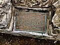
Plaque on the Star Gazers' Stone near Embreeville, PA.

