Tyneham Cap facts for kids
Quick facts for kids Tyneham Cap |
|
|---|---|

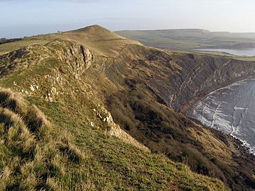
Tyneham Cap seen from Gad Cliff
|
|
| Highest point | |
| Elevation | 167 m (548 ft) |
| Prominence | 64 m (210 ft) |
| Parent peak | Swyre Head |
| Geography | |
| Location | Dorset, England |
| Parent range | Purbeck Hills |
| OS grid | SY891797 |
| Topo map | OS Landranger 195; Explorer 15E |
| Geology | |
| Mountain type | TuMP |
Tyneham Cap is a noticeable, grassy hill in Dorset, England. It stands 167 meters (about 548 feet) tall. This hill is part of the famous South West Coast Path.
From Tyneham Cap, you can see amazing views. It looks out over Brandy Bay and the beautiful Jurassic Coast. You can spot places like Kimmeridge Bay and Swyre Head to the east. To the west, you can see Worbarrow Bay and Lulworth Cove. Tyneham Cap is known as a 'TuMP' because it stands out clearly from the land around it.
Where is Tyneham Cap Located?
Tyneham Cap is found within the Lulworth Ranges. This area is sometimes used for military training, so access can be limited for safety. To the south, the land drops sharply over a rocky cliff called Gad Cliff. This cliff leads down to Brandy Bay on the English Channel.
To the north of Tyneham Cap is a valley that runs from east to west. In this valley, you'll find the abandoned village of Tyneham and the village of Steeple. Across the valley, you can see the main ridge of the Purbeck Hills. These hills include Povington Hill (191 meters high) and Ridgeway Hill (199 meters high).
Much of the land around Tyneham Cap is open grassland and fields. There are also small woods and groups of trees in the valleys and on the hillsides. The closest villages are Steeple, which is just over a mile away to the northwest, and Kimmeridge, about a mile and a half to the east.
 | Mary Eliza Mahoney |
 | Susie King Taylor |
 | Ida Gray |
 | Eliza Ann Grier |

