Upper Yarraman, Queensland facts for kids
Quick facts for kids Upper YarramanQueensland |
|||||||||||||||
|---|---|---|---|---|---|---|---|---|---|---|---|---|---|---|---|

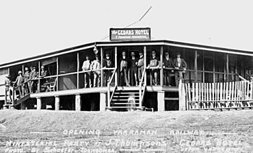
Cedars Hotel, 1913
|
|||||||||||||||
| Population | 80 (2021 census) | ||||||||||||||
| • Density | 1.92/km2 (5.0/sq mi) | ||||||||||||||
| Established | 1897 | ||||||||||||||
| Postcode(s) | 4614 | ||||||||||||||
| Area | 41.6 km2 (16.1 sq mi) | ||||||||||||||
| Time zone | AEST (UTC+10:00) | ||||||||||||||
| Location | |||||||||||||||
| LGA(s) | Toowoomba Region | ||||||||||||||
| State electorate(s) | Nanango | ||||||||||||||
| Federal Division(s) | Maranoa | ||||||||||||||
|
|||||||||||||||
Upper Yarraman is a small rural area in Queensland, Australia. It is part of the Toowoomba Region. In 2021, about 80 people lived in Upper Yarraman. It is a quiet place with a rich history.
Contents
Where is Upper Yarraman Located?
Upper Yarraman is found in a region called the Darling Downs. This area is known for its farming land. The New England Highway passes right through Upper Yarraman. This highway is an important road for travel. The area is also part of the Cooyar Creek catchment. A catchment is an area of land where all the rain and water flows into a particular river. Cooyar Creek eventually flows into the Brisbane River.
A Look Back: The History of Upper Yarraman
The land around Upper Yarraman was first measured and mapped in 1897. After this, people could choose pieces of land to live on. They had to clear the land and grow crops. This helped the area to develop.
What Does "Yarraman" Mean?
The name "Yarraman" comes from an Aboriginal word. It means "horse." While we don't know the exact origin of the word, some think it comes from "yira." This word means "large teeth."
Schools in the Past
A school called Yarraman Creek Upper Provisional School opened in 1905. It became Yarraman Creek Upper State School in 1909. Around 1935, its name changed to Yarraman Upper State School. This school closed its doors on December 31, 2002. The old school building is now a home.
The Cedars Hotel
A road junction in Upper Yarraman became a popular meeting spot. The Cedars Hotel first opened in 1913. Jack Thompson was its first owner. The hotel was used for a special lunch in 1913. This was after the railway opened in nearby Yarraman. Sadly, the hotel burned down in 1927. It was rebuilt, but then burned down again in 1960.
The Farmers' Hall
The Upper Yarraman Farmers' Hall has an interesting story. It was once a movie theater called the Phoenix Picture Theatre. This theater was in Blackbutt. In 1945, the hall was taken apart. Then, it was rebuilt in its current spot in Upper Yarraman. Mr. Horace Lougheed generously gave the land for the hall.
Churches and Communication
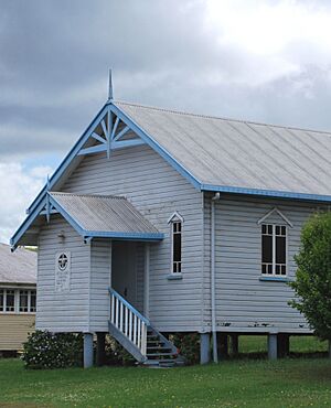
In 1922, people decided to build a Methodist church in Upper Yarraman. In 1965, this church building was moved to Yarraman. It became the Methodist Church there. The old Yarraman Methodist Church became the church hall. Today, it is known as the Yarraman Uniting Church.
In 1924, a new telephone line and public telegraph office were set up. The town had a telephone exchange until 1986. A post office also served the community until 1974.
The Pine Forest
On the northern side of the Yarraman Creek Valley, there is a large pine forest. It is just outside Upper Yarraman. This forest is a plantation of hoop pines. These trees were planted around 1939 to 1940.
How Many People Live in Upper Yarraman?
The number of people living in Upper Yarraman has changed over time. In 2016, there were 104 people living there. By 2021, the population was 80 people.
Learning and Education
There are no schools directly in Upper Yarraman today. Students usually go to schools in nearby towns. The closest primary schools are Yarraman State School in Yarraman. There is also Cooyar State School in Cooyar. Another option is Tanduringie State School in Pimpimbudgie.
For older students, Yarraman State School offers education up to Year 10. Nanango State High School in Nanango provides schooling up to Year 12.
 | Laphonza Butler |
 | Daisy Bates |
 | Elizabeth Piper Ensley |


