
Utsjoki facts for kids
Quick facts for kids
Utsjoki
Uccjuuhâ (Inari Sami)
Uccjokk (Skolt Sami) |
||
|---|---|---|
|
Municipality
|
||
| Utsjoen kunta (Finnish) Ohcejoga gielda (Northern Sami) Utsjoki kommun (Swedish) |
||

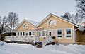
Utsjoki Church and a log cabin
|
||
|
||

Location of Utsjoki in Finland
|
||
| Country | ||
| Region | Lapland | |
| Sub-region | Northern Lapland | |
| Charter | 1876 | |
| Area
(2018-01-01)
|
||
| • Total | 5,372.00 km2 (2,074.14 sq mi) | |
| • Land | 5,147.16 km2 (1,987.33 sq mi) | |
| • Water | 227.51 km2 (87.84 sq mi) | |
| Area rank | 10th largest in Finland | |
| Population
(2023-12-31)
|
||
| • Total | 1,139 | |
| • Rank | 290th largest in Finland | |
| • Density | 0.22/km2 (0.6/sq mi) | |
| Population by native language | ||
| • Finnish | 53.9% (official) | |
| • Swedish | 0.2% | |
| • Sami | 41.5% | |
| • Others | 4.4% | |
| Population by age | ||
| • 0 to 14 | 12.6% | |
| • 15 to 64 | 56.4% | |
| • 65 or older | 30.9% | |
| Time zone | UTC+02:00 (EET) | |
| • Summer (DST) | UTC+03:00 (EEST) | |

Utsjoki (pronounced oot-syoh-kee) is a special place in Finland. It is the northernmost municipality in the entire country. Imagine being at the very top of Finland!
This area is located in Lapland. It shares a border with Norway and also with another Finnish municipality called Inari. Utsjoki was officially started in 1876.
Utsjoki has a population of 1,139 people. It covers a large area of 5,372.00 square kilometres (2,074.14 sq mi). A small part of this area, 227.51 km2 (87.84 sq mi), is water.
Utsjoki has two official languages: Finnish and Northern Sami. It's unique because it has the highest number of Sami speakers in Finland. About 41.5% of the people here speak Sami.
The border with Norway follows the Teno River. This river flows all the way to the Arctic Sea. The village of Nuorgam in Utsjoki is the northernmost village in Finland. It's also the northernmost land border crossing in the whole European Union!
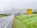
Utsjoki is at the end of Highway 4. This is the longest highway in Finland. The European route E75 also passes through Utsjoki. It crosses into Norway using the Sami Bridge.
A special place in Utsjoki is the Kevo nature reserve. It's a huge area of 712 km2 (275 sq mi). There's a long hiking trail, 63 km (39 mi), that goes through it. Part of this trail follows the edge of the amazing Kevo gorge.
The name Utsjoki comes from the Northern Sami word Ohcejohka. The exact meaning of this old name is not fully known.
Contents
Exploring Utsjoki's Geography
Utsjoki is a fascinating place with unique natural features.
Villages to Discover
Utsjoki is made up of several smaller communities. These include:
- Nuorgam
- Utsjoki centre (the main village)
- Nuvvus
- Dalvadas
- Outakoski
- Rovisuvanto
- Karigasniemi
- Kaamasmukka
Landscapes and Hills
The land in Utsjoki is generally flatter than other parts of Lapland. Most areas are less than 300 meters above sea level. The hills, called fells, are usually under 500 meters high. They have gentle slopes and flat tops. This kind of landscape is typical of very old land surfaces.
Plants and Trees
In Utsjoki, you'll find a clear line where trees stop growing. This is called the tree line. It's usually between 300 and 400 meters high. In the very north, on slopes facing north, the tree line can be as low as 100 meters.
Above the tree line, you'll see open areas called heaths. Lower down, these heaths have small shrubs. These include dwarf birch, blueberry, and crowberry. Higher up on the fells, you'll find tiny dwarf willows and alpine grasses. There are also lots of lichens and mosses.
On the very tops of the fells, the ground is often rocky. You might see areas of bare rock or ground shaped into patterns by the cold.
Understanding the Climate
Utsjoki has a subarctic climate. This means it has long, cold winters and short, cool summers. Because it's so far north, the average temperature for the whole year is below freezing.
Midnight Sun and Polar Night
One of the coolest things about Utsjoki is the amount of daylight.
- The midnight sun stays above the horizon from May 17 to July 28. That's 73 days of continuous daylight!
- The polar night happens from November 26 to January 15. During this time, the sun doesn't rise at all for 51 days.
Precipitation and Snow
Utsjoki is actually the driest place in Finland. It gets between 371 and 433 millimeters of rain or snow each year. The driest year ever recorded was 1986, with only 234 millimeters of precipitation.
Because it's so cold and dry, the snow cover in winter is usually thin. Strong winds at higher elevations can blow the snow away. This means that exposed hilltops often have no snow in winter. This lack of snow can make the ground even colder.
What is Permafrost?
Permafrost is ground that stays frozen for at least two years in a row. It's a common feature in northern Finland.
Palsas: Frozen Mounds
One interesting type of permafrost is found in palsas. These are mounds of peat (a type of soil made from decayed plants) with a frozen core. Dry peat acts like a good blanket in summer, keeping the heat out. But in winter, frozen peat helps the cold go deep into the ground. This allows palsas to form even when the average air temperature is just around freezing.
Scientists have studied palsas in the Kevo and Utsjoki regions for a long time. They used to think permafrost only existed inside these palsa mounds. But new methods, like using special electrical measurements, helped them look deeper. These methods can measure how thick the frozen ground is.
Discovering Widespread Permafrost
A famous expert on palsas, Matti Seppälä, suggested looking for permafrost in the mountains of northern Finland. In 1985, a team did research in Utsjoki. They found something surprising! Above the tree line, the permafrost was much thicker than expected. It was at least 10 to 50 meters deep.
This means that permafrost is likely found all over the mountain tops in northern Finland. For example, on the Puollamoaivi mountain, scientists believe the permafrost could be over 100 meters thick in some spots. This information is important for building things like cell phone towers, which need strong foundations.
| Climate data for Utsjoki Kevo (1991–2020 normals, records 1962–present) | |||||||||||||
|---|---|---|---|---|---|---|---|---|---|---|---|---|---|
| Month | Jan | Feb | Mar | Apr | May | Jun | Jul | Aug | Sep | Oct | Nov | Dec | Year |
| Record high °C (°F) | 6.2 (43.2) |
6.3 (43.3) |
9.2 (48.6) |
15.7 (60.3) |
30.5 (86.9) |
32.5 (90.5) |
33.6 (92.5) |
31.5 (88.7) |
24.3 (75.7) |
13.7 (56.7) |
8.7 (47.7) |
7.1 (44.8) |
33.6 (92.5) |
| Mean maximum °C (°F) | 2.1 (35.8) |
2.2 (36.0) |
4.3 (39.7) |
9.5 (49.1) |
18.4 (65.1) |
24.6 (76.3) |
27.4 (81.3) |
24.5 (76.1) |
17.9 (64.2) |
9.7 (49.5) |
3.4 (38.1) |
2.9 (37.2) |
28.3 (82.9) |
| Mean daily maximum °C (°F) | −8.6 (16.5) |
−8.0 (17.6) |
−2.8 (27.0) |
2.8 (37.0) |
8.5 (47.3) |
14.7 (58.5) |
18.7 (65.7) |
16.0 (60.8) |
10.4 (50.7) |
2.4 (36.3) |
−3.7 (25.3) |
−6.1 (21.0) |
3.7 (38.6) |
| Daily mean °C (°F) | −13.3 (8.1) |
−12.6 (9.3) |
−7.8 (18.0) |
−1.9 (28.6) |
4.2 (39.6) |
9.8 (49.6) |
13.4 (56.1) |
11.1 (52.0) |
6.4 (43.5) |
−0.4 (31.3) |
−7.2 (19.0) |
−10.6 (12.9) |
−0.7 (30.7) |
| Mean daily minimum °C (°F) | −18.3 (−0.9) |
−17.6 (0.3) |
−13.3 (8.1) |
−6.9 (19.6) |
−0.1 (31.8) |
5.3 (41.5) |
8.7 (47.7) |
6.9 (44.4) |
2.9 (37.2) |
−3.2 (26.2) |
−11.2 (11.8) |
−15.3 (4.5) |
−5.2 (22.7) |
| Mean minimum °C (°F) | −35.1 (−31.2) |
−34.3 (−29.7) |
−28.0 (−18.4) |
−21.8 (−7.2) |
−7.6 (18.3) |
0.2 (32.4) |
3.4 (38.1) |
0.2 (32.4) |
−3.9 (25.0) |
−15.5 (4.1) |
−24.8 (−12.6) |
−30.7 (−23.3) |
−37.4 (−35.3) |
| Record low °C (°F) | −48.2 (−54.8) |
−47.9 (−54.2) |
−39.1 (−38.4) |
−31.9 (−25.4) |
−20.9 (−5.6) |
−3.4 (25.9) |
−0.1 (31.8) |
−3.9 (25.0) |
−11.9 (10.6) |
−28.9 (−20.0) |
−36.1 (−33.0) |
−41.4 (−42.5) |
−48.2 (−54.8) |
| Average precipitation mm (inches) | 26 (1.0) |
25 (1.0) |
21 (0.8) |
22 (0.9) |
30 (1.2) |
56 (2.2) |
73 (2.9) |
59 (2.3) |
38 (1.5) |
38 (1.5) |
27 (1.1) |
28 (1.1) |
443 (17.5) |
| Average precipitation days (≥ 0.1 mm) | 21 | 18 | 17 | 15 | 16 | 17 | 18 | 18 | 18 | 20 | 20 | 21 | 219 |
| Average relative humidity (%) | 84 | 83 | 79 | 76 | 71 | 69 | 74 | 81 | 85 | 89 | 89 | 87 | 81 |
| Mean monthly sunshine hours | 4 | 47 | 130 | 181 | 193 | 216 | 209 | 127 | 88 | 51 | 9 | 0 | 1,255 |
| Source 1: FMI climatological normals for Finland 1991–2020 | |||||||||||||
| Source 2: record highs and lows | |||||||||||||
| Climate data for Utsjoki Outakoski, 1981–2010 normals | |||||||||||||
|---|---|---|---|---|---|---|---|---|---|---|---|---|---|
| Month | Jan | Feb | Mar | Apr | May | Jun | Jul | Aug | Sep | Oct | Nov | Dec | Year |
| Average precipitation mm (inches) | 22 (0.9) |
20 (0.8) |
16 (0.6) |
19 (0.7) |
17 (0.7) |
38 (1.5) |
61 (2.4) |
54 (2.1) |
35 (1.4) |
38 (1.5) |
29 (1.1) |
22 (0.9) |
371 (14.6) |
| Source: FMI open data, 1981–2010 | |||||||||||||
People from Utsjoki
Many interesting people have come from Utsjoki. Here are a few:
- Inger-Mari Aikio-Arianaick: A writer born in Utsjoki in 1961.
- Pigga Keskitalo: A Sámi academic (university expert) born in Utsjoki in 1972.
- Helvi Poutasuo (1943–2017): A teacher, translator, editor, and politician.
- Irja Seurujärvi-Kari (born 1947): A politician and academic.
Images for kids
-
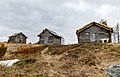
Old cabins on the hill
-
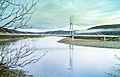
Utsjoki seen from Norway
-
The Sami Bridge connects Utsjoki to Norway
-
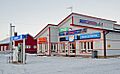
Samimootor, a car repair shop and filling station in Nuorgam, Utsjoki
-
Nuorgamin lomakeskus, the camping center of Nuorgam
.jpg)


See also
 In Spanish: Utsjoki para niños
