Verendrye Site facts for kids
|
Verendrye Site
|
|

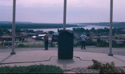
Monument at the site
|
|
| Location | Verendrye Dr., Fort Pierre, South Dakota |
|---|---|
| NRHP reference No. | 74001899 |
Quick facts for kids Significant dates |
|
| Added to NRHP | August 7, 1974 |
| Designated NHL | July 17, 1991 |
The Verendrye Site is a special historical place in Fort Pierre, South Dakota. It's where two French explorers, the La Vérendrye brothers, buried a lead plate. This plate had the French royal symbol on it. They did this to claim the land for France way back in 1743.
This site is now a small public park. It was named a National Historic Landmark in 1991. This means it's a very important historical place in the United States. A monument stands there today to tell its story.
Contents
What the Verendrye Site Looks Like
The Verendrye Site is on a small hill. It looks over the Missouri River from the west bank. The river flows between Fort Pierre and Pierre. You can get to the site by a paved road from Verendrye Drive.
There's a small circular area for parking cars. Right next to it, you'll see the monument. This monument is made of granite rock. It stands about 4 feet (1.2 meters) tall.
The Monument's Message
The monument has an important message carved into it. It says: "Here on March 30, 1743, The Verendryes Buried a lead tablet to claim this region for France." It also says: "This tablet found on Feb. 16, 1913, is the first written record of the visit of white men to South Dakota."
Below that, in smaller letters, it adds: "Erected by State Historical Society and Ft. Pierre Commercial Club 1933." This tells us who put the monument there and when.
The Verendrye Brothers' Journey
Pierre Gaultier de Varennes, sieur de La Vérendrye was a famous explorer for New France. New France was what Canada and parts of the US were called when they were French colonies. Pierre and his four sons explored many areas of North America. They traveled across the northern plains.
By the 1730s, the Vérendrye family had set up trading posts. These posts were in places that are now North Dakota and Canada.
Exploring West to the Rocky Mountains
In 1742 and 1743, the brothers went on another big trip. They wanted to explore even further west. Their main goal was to reach the Pacific Ocean. They did not reach the Pacific Ocean on this trip.
Historians believe they explored parts of what are now Montana and Wyoming. There's still some discussion about exactly where they went. It's also debated which Native American groups they met.
The Secret Lead Plate
The brothers leading this trip were likely Louis-Joseph Gaultier de La Vérendrye and François de La Vérendrye. They secretly buried a lead plate. This plate was about 8.5 inches by 6.5 inches in size. It had the French coat of arms on it. It also had Latin words about the King of France.
They buried it on a bluff overlooking the Missouri River. They built a pile of stones over the spot. They told the local Native Americans that the stones were a memorial. But secretly, it was their way of claiming the land for France.
Discovery of the Plate
The lead plate was lost for many years. Then, in 1913, something amazing happened. Some children were playing on the hillside. The hill was eroding, meaning the soil was wearing away. The children found the lead plate!
This plate is now kept by the state historical society. The city has made the site a park to protect it. In 1933, a 4-foot monument was put up at the site. This was done by the state historical society and a local business group. It marks the spot for its historical importance.
Today, flags from the United States, France, and South Dakota fly at the site. People have also looked for other old items there. Finding the lead plate helped experts understand more about the Verendrye expedition.
See also


