Vinings, Georgia facts for kids
Quick facts for kids
Vinings, Georgia
|
|
|---|---|

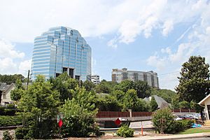
High rises on Mount Wilkinson
|
|

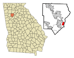
Location in Cobb County and the state of Georgia
|
|
| Country | United States |
| State | Georgia |
| County | Cobb |
| Area | |
| • Total | 3.23 sq mi (8.37 km2) |
| • Land | 3.13 sq mi (8.10 km2) |
| • Water | 0.10 sq mi (0.27 km2) |
| Elevation | 915 ft (279 m) |
| Population
(2020)
|
|
| • Total | 12,581 |
| • Density | 4,024.63/sq mi (1,553.80/km2) |
| Time zone | UTC-5 (Eastern (EST)) |
| • Summer (DST) | UTC-4 (EDT) |
| ZIP code |
30339
|
| Area code(s) | 770/678/470 |
| FIPS code | 13-79612 |
| GNIS feature ID | 0356615 |
| Website | http://www.vinings.com/ |
Vinings is a community in Cobb County, Georgia, USA. It is located right by the Chattahoochee River. In 2020, about 12,581 people lived there. Vinings is close to Atlanta and is known for its history, shops, and natural areas. It is also near major roads and a fun place called The Battery. The main office for The Home Depot is in Vinings.
Contents
History of Vinings
How Vinings Got Its Name
Long ago, Vinings was known by other names like Crossroads and then Paces. This was around 1830. A man named Hardy Pace ran a ferry across the Chattahoochee River here. This area was between Atlanta, Buckhead, and Smyrna. Today, Paces Ferry Road is still the main road through Vinings.
In the 1840s, the Western and Atlantic Railroad built train tracks from Chattanooga, Tennessee to Atlanta. Vinings became a place where they stopped to build the railroad. The community was named after William H. Vining, who worked on building "Vining's Bridge" for the tracks. The railroad is still owned by the state and is now used by CSX.
Vinings During the Civil War
During the American Civil War in 1864, the Union Army led by William Tecumseh Sherman came through Vinings. This was part of his Atlanta Campaign and later his March to the Sea. Hardy Pace's home, which had been used as a hospital, was destroyed during this time.
Rebuilding and Recognition
After the war, Vinings began to recover. The governor leased the railroad to Vinings to bring people to the springs and pavilions. These places were built to help people relax after the hard times of the Reconstruction period in Atlanta.
Vinings was officially recognized as a community in 1904. That same year, a one-lane bridge was built over the Chattahoochee River. Vinings has never officially become a city, though people have talked about it. The Vinings Historic Preservation Society works to keep the town's history alive for everyone to learn about.
Geography of Vinings
Vinings is located at 33°51′58.9″N 84°27′57.85″W / 33.866361°N 84.4660694°W. The United States Census Bureau says that the community covers about 3.3 square miles (8.37 square kilometers). Most of this area is land, with a small part being water.
Population of Vinings
Vinings was first listed as a special census area in the 1990 U.S. Census.
Population Changes Over Time
The number of people living in Vinings has changed over the years:
- 1990: 7,417 people
- 2000: 9,677 people
- 2010: 9,734 people
- 2020: 12,581 people
People in Vinings (2020 Census)
The 2020 census showed the different groups of people living in Vinings:
- White (not Hispanic or Latino): 51.34%
- Black or African American (not Hispanic or Latino): 32.18%
- Asian (not Hispanic or Latino): 5.48%
- People of two or more races (not Hispanic or Latino): 3.78%
- Hispanic or Latino (any race): 6.60%
- Other groups make up smaller percentages.
See also
In Spanish: Vinings para niños
 | Leon Lynch |
 | Milton P. Webster |
 | Ferdinand Smith |


