Mount Carrigain facts for kids
Quick facts for kids Mount Carrigain |
|
|---|---|

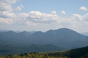
View of Mt. Carrigain from Mt. Guyot, taken August 2009. Vose Spur is the knob roughly in the center of the photo, and Mount Lowell is to its left.
|
|
| Highest point | |
| Elevation | 4,683 ft (1,427 m) NAVD 88 |
| Prominence | 2,223 ft (678 m) |
| Listing | New Hampshire 4000-footers #27 New England Fifty Finest |
| Geography | |
| Location | Grafton County, New Hampshire, U.S. |
| Topo map | USGS Mount Carrigain |
| Climbing | |
| First ascent | August 27, 1857; Arnold Guyot, S. Hastings Grant, and local guide Bill Hatch, |
| Easiest route | maintained hiking trail |
Mount Carrigain is a tall mountain found in Grafton County, New Hampshire. It was named after Phillip Carrigain, who was an important government official in New Hampshire a long time ago. This mountain is located on the south side of the Pemigewasset Wilderness. This wilderness area is where the East Branch of the Pemigawasset River begins. Mount Carrigain is right in the middle of the White Mountains, between two famous areas called Franconia Notch and Crawford Notch.
Mount Carrigain has a special fire tower at its very top. This tower gives amazing 360-degree views of the wild areas all around it.
Contents
Exploring Mount Carrigain's Location
Mount Carrigain is surrounded by other interesting mountains. To its northeast, you'll find Mount Anderson and Mount Lowell. These mountains are separated from Carrigain by a valley called Carrigain Notch. To the southwest, you'll see Mount Hancock.
How Water Flows from Mount Carrigain
The water that falls on the south side of Mount Carrigain flows into the Sawyer River. From there, it goes into the Saco River, which eventually reaches the Gulf of Maine near Saco, Maine.
The east side of Mount Carrigain drains into Carrigain Brook. This brook also joins the Sawyer River. Water from the north side of the mountain flows into the East Branch of the Pemigewasset River. This river is a tributary (a smaller river that flows into a larger one) of the Merrimack River. The Merrimack River then flows into the Gulf of Maine at Newburyport, Massachusetts. Finally, the west side of Carrigain drains into the Carrigain Branch, which is another part of the East Branch of the Pemigewasset River.
Discovering Vose Spur
| Vose Spur | |
|---|---|
| Highest point | |
| Elevation | 3,862 ft (1,177 m) |
| Prominence | 222 ft (68 m) |
| Listing | |
| Geography | |
| Topo map | USGS Mount Carrigain |
| Climbing | |
| Easiest route | 10-mile (16 km) bushwhack, approx. 9 hours, via route below |
Vose Spur is a smaller peak that is part of Mount Carrigain. It is named after George L. Vose. The top of Vose Spur is covered with many trees.
Hiking Vose Spur
There isn't an official hiking trail to the top of Vose Spur. Because of this, it is considered one of New England's one hundred highest summits that are "trailless." This means hikers have to find their own way through the woods, which is called bushwhacking.
On the eastern side of Vose Spur, there is a talus field. A talus field is a slope covered in broken rocks. If you bushwhack to this area from the Carrigain Notch Trail, you can get amazing views. From here, you can look into Carrigain Notch and see Mount Lowell across the way.

