Wahweap Creek facts for kids
Quick facts for kids Wahweap Creek |
|
|---|---|

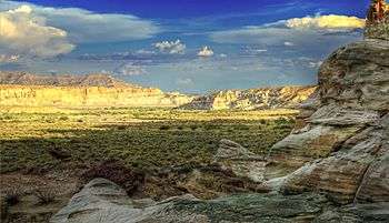
Wahweap Creek Valley
|
|
| Country | United States |
| State | Utah |
| Physical characteristics | |
| Main source | Canaan Peak Dixie National Forest, Garfield County, Utah 8,564 ft (2,610 m) 37°36′20″N 111°47′40″W / 37.60556°N 111.79444°W |
| River mouth | Lake Powell/Colorado River Glen Canyon National Recreation Area, Kane County, Utah 3,704 ft (1,129 m) 37°02′15″N 111°34′18″W / 37.03750°N 111.57167°W |
| Length | 55.6 mi (89.5 km) |
| Basin features | |
| Basin size | 453 sq mi (1,170 km2) |
| Tributaries |
|
Wahweap Creek is a stream in southern Utah, United States. It is about 55.6-mile (89.5 km) long. This creek is a branch of the Colorado River. It flows through a wild area with high mesas and deep canyons. This region is part of the Colorado Plateau.
The creek usually flows into Lake Powell. This large lake is a reservoir on the Colorado River. Wahweap Creek gives its name to the Wahweap Marina. This marina is a popular spot for people to visit the Glen Canyon National Recreation Area.
You can find the amazing Wahweap Hoodoos near the creek. These are tall, mushroom-shaped rock formations. The creek also cuts through areas with many fossils. These areas are part of the Wahweap Formation, which is named after the creek. It's important to be careful when visiting the area. Even though the creek is often dry, sudden, powerful flash floods can happen.
In the 1950s, a town called Glen Canyon City was built near Wahweap Creek. This town is now known as Big Water. It was a main camp for building the Glen Canyon Dam. This dam created Lake Powell. The creek bed was a key source of gravel for the concrete used in the dam.
Where Wahweap Creek Flows
Wahweap Creek starts in Garfield County, Utah. It begins near Canaan Peak, high up on the Kaiparowits Plateau. The creek starts at over 8,500 feet (2,600 m) above sea level. From there, it flows south into Kane County, Utah.
As it flows, other smaller creeks join it. These include Long Canyon and Tommy Smith Creeks. The creek then goes into a canyon. Here, it drops about 1,200 feet (370 m) in elevation over 15 miles (24 km). It continues south as a wide, dry streambed called an arroyo.
Coyote Creek joins it from the right. The creek then turns southeast, passing by Big Water, Utah. U.S. Route 89 runs alongside the creek in this area. Finally, Wahweap Creek empties into Wahweap Bay. This bay is an arm of Lake Powell.
The water level in Lake Powell changes a lot. It can be as low as 3,550 feet (1,080 m) during dry times. The highest recorded level was 3,708 feet (1,130 m). Before the Glen Canyon Dam was built, Wahweap Creek flowed for another 7 miles (11 km). It used to join the Colorado River near Page, Arizona.
The Creek's Surroundings
The area that Wahweap Creek drains is called its watershed. This watershed covers about 453 square miles (1,170 km2) of dry canyon land. The upper part of the creek flows through the Dixie National Forest. It also goes through the Grand Staircase–Escalante National Monument.
Much of the lower part of the creek is in the Glen Canyon National Recreation Area. Most of the land in this watershed, over 85 percent, is owned by the government. Only a small part of the creek, about 2.1 miles (3.4 km) at its start, has water all year round. This part of the creek has many fish.
 | Tommie Smith |
 | Simone Manuel |
 | Shani Davis |
 | Simone Biles |
 | Alice Coachman |


