
South Bristol, Maine facts for kids
Quick facts for kids
South Bristol, Maine
|
|
|---|---|

South Bristol Gut in 2022
|
|

Location in Lincoln County and the state of Maine
|
|
| Country | United States |
| State | Maine |
| County | Lincoln |
| Incorporated | 1915 |
| Area | |
| • Total | 29.68 sq mi (76.87 km2) |
| • Land | 13.10 sq mi (33.93 km2) |
| • Water | 16.58 sq mi (42.94 km2) |
| Elevation | 43 ft (13 m) |
| Population
(2020)
|
|
| • Total | 1,127 |
| • Density | 86/sq mi (33.2/km2) |
| Time zone | UTC-5 (Eastern (EST)) |
| • Summer (DST) | UTC-4 (EDT) |
| ZIP Codes |
04568 (South Bristol)
04573 (Walpole) |
| Area code(s) | 207 |
| FIPS code | 23-70240 |
| GNIS feature ID | 0582733 |
South Bristol is a small town located in Lincoln County, Maine, United States. In 2020, about 1,127 people lived there. It's known as a great place for fishing and vacations. South Bristol includes the small communities of Walpole and Christmas Cove. Christmas Cove is found on Rutherford Island. The town also has six special areas set aside to protect nature.
Contents
History of South Bristol
Early Days and Native Americans
Long ago, the land where South Bristol is now was home to the Wawenock people. They were a group of Abenaki Native Americans. They used canoes to travel and find food like fish, shellfish, seals, and birds.
In 1614, a famous explorer named Captain John Smith explored the coast. People say he named Christmas Cove because he visited it on Christmas Day. Later, in 1631, some merchants from Bristol, England, were given land here. This is how the town got its name.
Settlement and Conflicts
A palisade fort (a fort with strong wooden walls) and a settlement were built nearby. From 1630 to 1650, this area was a busy center for fur trading in Maine. However, during the French and Indian Wars, the fort was attacked and rebuilt many times. The last attacks happened in 1747.
In 1765, the larger town of Bristol was officially formed. South Bristol was part of it. But on March 26, 1915, South Bristol became its own separate town.
Industries and Growth
In the 1800s, the village of Walpole was famous for making bricks and harvesting ice. Bricks from Walpole were even used to build parts of Boston. The ice business later faded when refrigeration was invented. However, the Thompson Ice House, which started in 1826, is now a museum where you can learn about ice harvesting.
Shipbuilding has always been important here. During World War II, the Bristol Yacht Building Company built minesweepers for the United States Navy. Today, they still build schooners, fishing boats, lobster boats, and yachts. The famous Hudson River Sloop Clearwater was built here in 1968. Other important jobs in South Bristol include fishing, lobstering, clamming, aquaculture (farming seafood), and tourism.
Connecting the Island
The main part of South Bristol and Rutherford Island used to be connected by a swing bridge. This bridge could swing open to let boats pass. In 2017, a new, safer drawbridge was built to replace it. For over 100 years, Rutherford Island has been a popular vacation spot for families from other states like Massachusetts and New York. Many of these families own homes on the island.
-
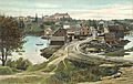
View of South Bristol in 1908
-
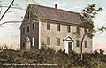
Walpole Meeting House c. 1908
-
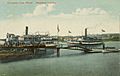
Steamboat landing in 1910


Geography
South Bristol is located in the southern part of Lincoln County. To its west is the Damariscotta River, and to the east are Johns Bay and the Johns River. The Atlantic Ocean is to the south.
About one-third of the town is on Rutherford Island. This island is separated from the mainland by a narrow waterway called "The Gut." Rutherford Island was named after Reverend Robert Rutherford, who came to the area in 1729. The main village of South Bristol is on both sides of The Gut. Christmas Cove is at the southern end of Rutherford Island. The areas of West Bristol and Walpole are on the mainland to the north.
According to the United States Census Bureau, South Bristol covers a total area of about 29.68 square miles (76.87 km²). A large part of this area, about 16.58 square miles (42.94 km²), is water.
Maine State Route 129 is the main highway that goes through the town. This road leads north to Damariscotta, which is about 13 miles (21 km) from South Bristol village.
Demographics
| Historical population | |||
|---|---|---|---|
| Census | Pop. | %± | |
| 1920 | 581 | — | |
| 1930 | 563 | −3.1% | |
| 1940 | 582 | 3.4% | |
| 1950 | 631 | 8.4% | |
| 1960 | 610 | −3.3% | |
| 1970 | 664 | 8.9% | |
| 1980 | 800 | 20.5% | |
| 1990 | 825 | 3.1% | |
| 2000 | 897 | 8.7% | |
| 2010 | 892 | −0.6% | |
| 2020 | 1,127 | 26.3% | |
| U.S. Decennial Census | |||
Population Changes
The population of South Bristol has changed over the years. In 1920, there were 581 people. By 2010, the population was 892. The most recent count in 2020 showed that 1,127 people live in South Bristol.
Sites of Interest
- South Bristol Historical Society - Learn about the town's past.
- Thompson Ice Harvesting Museum - See how ice was harvested long ago.
- Walpole Meeting House (1772) - A historic building from 1772.
- Witch Island Preserve - A nature area to explore.
Images for kids
-
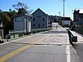
The former swing bridge

See also
 In Spanish: South Bristol (Maine) para niños
