
War Eagle Creek facts for kids
Quick facts for kids War Eagle Creek |
|
|---|---|

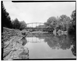
War Eagle Creek from the War Eagle Bridge in War Eagle, April 2015
|
|

Location of the mouth of the War Eagle Creek in Arkansas
|
|
| Country | United States |
| State | Arkansas |
| Physical characteristics | |
| Main source | 35°50′28″N 93°37′10″W / 35.84111°N 93.61944°W |
| River mouth | 36°13′47″N 93°59′53″W / 36.22972°N 93.99806°W |
| Basin features | |
| Progression | White River—Mississippi River |
| River system | Mississippi River |
| Bridges | Eagle Creek Bridge |
| GNIS feature ID | 56034 |
War Eagle Creek is a cool stream located in northwest Arkansas, United States. It flows through Benton, Washington, and Madison counties. This creek is a branch, or tributary, of the larger White River.
Contents
Journey of War Eagle Creek
Where the Creek Begins
War Eagle Creek starts in Madison County. Its source is in the Boston Mountains. This area is west of a small town called Boston. The creek begins at a high point, about 2,100 feet (640 meters) above sea level.
Flowing Through Arkansas
From its start, the creek flows mostly northwest. It passes by several communities. These include Witter and Aurora. The creek also flows near the town of Huntsville. It goes under U.S. Route 412 near Harmony.
The creek then turns northwest again. It flows past the south side of Withrow Springs State Park. It continues its journey, passing under Arkansas Highway 45. This is north of Hindsville.
Entering Beaver Lake
War Eagle Creek then moves into Benton County. It passes under Arkansas Highway 303 near War Eagle. Here, the creek makes a very sharp turn. This is called an incised meander.
Finally, the creek flows into Beaver Lake. This large lake was created by a dam. Before the lake was built, the creek flowed directly into the White River.
Name of the Creek
The creek gets its name from a Native American leader. This leader was known as War Eagle.
