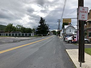
Wardensville, West Virginia facts for kids
Quick facts for kids
Wardensville, West Virginia
|
||
|---|---|---|
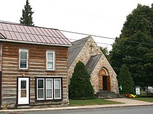
Historic structures along Main Street in Wardensville, West Virginia
|
||
|
||
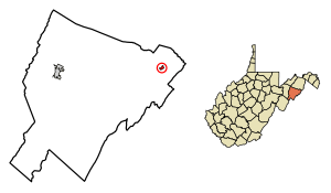
Location of Wardensville in Hardy County, West Virginia.
|
||
| Country | United States | |
| State | West Virginia | |
| County | Hardy | |
| Government
Town Council is made up of five Councilors, a Mayor and a Recorder
|
||
| • Type | Mayor/Council | |
| Area | ||
| • Total | 0.33 sq mi (0.85 km2) | |
| • Land | 0.32 sq mi (0.84 km2) | |
| • Water | 0.01 sq mi (0.01 km2) | |
| Elevation | 1,010 ft (308 m) | |
| Population
(2020)
|
||
| • Total | 265 | |
| • Estimate
(2021)
|
267 | |
| • Density | 796.30/sq mi (307.00/km2) | |
| Time zone | UTC-5 (Eastern (EST)) | |
| • Summer (DST) | UTC-4 (EDT) | |
| ZIP code |
26851
|
|
| Area code(s) | 304 | |
| FIPS code | 54-84580 | |
| GNIS feature ID | 1553382 | |
Wardensville is a small town in Hardy County, West Virginia, United States. In 2020, about 265 people lived there.
The town was first called Trout Run. It became an official town in Virginia in 1832. Later, in 1879, it became part of West Virginia. Wardensville is located west of the Great North Mountain range. This mountain range separates it from the Shenandoah Valley. The town sits on the east bank of the Cacapon River. The George Washington and Jefferson National Forests are also nearby.
Contents
History of Wardensville
The land where Wardensville is today was once part of a huge area called the Northern Neck Proprietary. This land was given by King Charles II of England in 1660. In 1719, Thomas Fairfax, 6th Lord Fairfax of Cameron took over the land. He gave parts of it to early European settlers.
William H. Warden is thought to be the first settler in the area. He received land from Thomas Fairfax in 1749. It is said that George Washington helped survey this land.
Early Forts and Attacks
During the French and Indian War, there were fights between English settlers and Native American groups. To stay safe, settlers built forts. One of these was Fort Warden, also known as "Warden's Fort." William Warden built it in a place called Trout Run.
In 1758, the fort was attacked and burned. William Warden and another man named Mr. Taff died in this attack.
Becoming a Town
Wardensville officially became a town in 1832. The Virginia General Assembly gave it a special paper called a charter. This paper said that Wardensville was a town with its own lots, streets, and alleys. The first leaders of the town were James Scanting, Samuel Fry, John Pierce, Simon Switzer, and James W. Baker. Later, in 1879, the West Virginia Legislature officially made it a town.
In 1820, the center of the United States population was very close to Wardensville. It was about 3 miles northeast of the town.
Historic Buildings in Town
Wardensville has several old and important buildings:
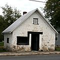
- Cline Blacksmith Shop/Town Jail: This stone building was built around 1830. The Cline family ran a blacksmith shop here until 1895. Later, it became the town's jail.
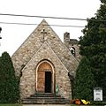
- St. Peter's Lutheran Church: This church started in 1840. Its first building was put up in 1870. After that building fell down in 1934, the current stone church was built. It has a Gothic Revival style.
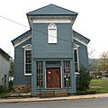
- Old Presbyterian Church: This church was built in the late 1800s. It shows a rare Italianate style for Wardensville.
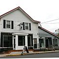
- Odd Fellows Hall: This building was put up in 1856. It is on the south side of town, near Main Street.
Two other places near Wardensville are listed on the National Register of Historic Places. These are the Francis Kotz Farm and the Nicholas Switzer House.
Historic Images
Getting Around Wardensville
Three main roads go through Wardensville. They all run together through the town on Main Street. These roads are U.S. Route 48, West Virginia Route 55, and West Virginia Route 259.
There are plans to build a new path for these roads around Wardensville. For now, they all go right through the center of town. U.S. Route 48 and WV 55 go west to Moorefield and east to Strasburg. WV 259 goes southwest and northeast.
Geography and Rivers
Wardensville is located at 39°4′32″N 78°35′40″W / 39.07556°N 78.59444°W.
The town covers about 0.33 square miles (0.85 square kilometers). Most of this area is land, with a small part being water.
The Lost River flows into Wardensville from the southwest. Once it reaches the town, it changes its name to the Cacapon River. This river then flows northeast towards the Potomac River.
People of Wardensville
| Historical population | |||
|---|---|---|---|
| Census | Pop. | %± | |
| 1880 | 123 | — | |
| 1890 | 106 | −13.8% | |
| 1900 | 152 | 43.4% | |
| 1910 | 123 | −19.1% | |
| 1920 | 745 | 505.7% | |
| 1930 | 189 | −74.6% | |
| 1940 | 195 | 3.2% | |
| 1950 | 171 | −12.3% | |
| 1960 | 289 | 69.0% | |
| 1970 | 288 | −0.3% | |
| 1980 | 241 | −16.3% | |
| 1990 | 140 | −41.9% | |
| 2000 | 246 | 75.7% | |
| 2010 | 271 | 10.2% | |
| 2020 | 265 | −2.2% | |
| 2021 (est.) | 267 | −1.5% | |
| U.S. Decennial Census | |||
Population in 2010
In 2010, there were 271 people living in Wardensville. There were 126 households and 67 families. The town had about 847 people per square mile (327 people per square kilometer).
Most of the people in Wardensville were White (96.3%). A small number were African American (1.8%) or Asian (1.1%). About 2.2% of the people were Hispanic or Latino.
About 25% of households had children under 18 living with them. Many households (40.5%) were married couples. The average age in the town was 45.3 years old. About 19% of residents were under 18.
See also
 In Spanish: Wardensville (Virginia Occidental) para niños
 | Lonnie Johnson |
 | Granville Woods |
 | Lewis Howard Latimer |
 | James West |


