Wayne County, Mississippi facts for kids
Quick facts for kids
Wayne County
|
|
|---|---|

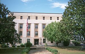
Wayne County courthouse in Waynesboro
|
|

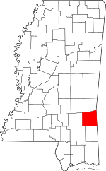
Location within the U.S. state of Mississippi
|
|
 Mississippi's location within the U.S. |
|
| Country | |
| State | |
| Founded | 1809 |
| Named for | Anthony Wayne |
| Seat | Waynesboro |
| Largest city | Waynesboro |
| Area | |
| • Total | 814 sq mi (2,110 km2) |
| • Land | 811 sq mi (2,100 km2) |
| • Water | 2.8 sq mi (7 km2) 0.3% |
| Population
(2020)
|
|
| • Total | 19,779 |
| • Density | 24.299/sq mi (9.382/km2) |
| Time zone | UTC−6 (Central) |
| • Summer (DST) | UTC−5 (CDT) |
| Congressional district | 4th |
Wayne County is a county located in the U.S. state of Mississippi. It is found in the southeastern part of the state. As of the 2020 census, about 19,779 people lived there.
The main town, or county seat, is Waynesboro. A county seat is like the capital city of a county, where the government offices are. The county is named after General Anthony Wayne, a hero from American history.
Contents
Exploring Wayne County's Geography
Wayne County covers a total area of about 814 square miles. Most of this area, around 811 square miles, is land. The rest, about 2.8 square miles, is water. This makes Wayne County the fifth-largest county in Mississippi based on its land size.
Main Roads in Wayne County
These are the most important highways that run through Wayne County:
Neighboring Counties
Wayne County shares its borders with several other counties:
- Clarke County to the north
- Choctaw County, Alabama to the northeast
- Washington County, Alabama to the southeast
- Greene County to the south
- Perry County to the southwest
- Jones County to the west
- Jasper County to the northwest
Protected Natural Areas
Part of the De Soto National Forest is located within Wayne County. This is a large area of protected land, great for nature and outdoor activities.
People and Population of Wayne County
| Historical population | |||
|---|---|---|---|
| Census | Pop. | %± | |
| 1810 | 1,253 | — | |
| 1820 | 3,323 | 165.2% | |
| 1830 | 2,781 | −16.3% | |
| 1840 | 2,120 | −23.8% | |
| 1850 | 2,892 | 36.4% | |
| 1860 | 3,691 | 27.6% | |
| 1870 | 4,206 | 14.0% | |
| 1880 | 8,741 | 107.8% | |
| 1890 | 9,817 | 12.3% | |
| 1900 | 12,539 | 27.7% | |
| 1910 | 14,709 | 17.3% | |
| 1920 | 15,467 | 5.2% | |
| 1930 | 15,295 | −1.1% | |
| 1940 | 16,928 | 10.7% | |
| 1950 | 17,010 | 0.5% | |
| 1960 | 16,258 | −4.4% | |
| 1970 | 16,650 | 2.4% | |
| 1980 | 19,135 | 14.9% | |
| 1990 | 19,517 | 2.0% | |
| 2000 | 21,216 | 8.7% | |
| 2010 | 20,747 | −2.2% | |
| 2020 | 19,779 | −4.7% | |
| 2023 (est.) | 19,703 | −5.0% | |
| U.S. Decennial Census 1790–1960 1900–1990 1990–2000 2010–2013 |
|||
The population of Wayne County has changed over many years. In 2020, there were 19,779 people living in the county. These people lived in 7,683 households, with 5,390 of them being families.
Towns and Places in Wayne County
Wayne County has different types of communities, from cities to small, quiet areas.
Cities
- Waynesboro: This is the biggest city and the county seat.
Towns
- State Line: This town is mostly in Greene County, but a small part is in Wayne County.
Census-Designated Places
These are areas that are like towns but are not officially incorporated as cities or towns. They are defined by the U.S. Census Bureau for statistical purposes.
- Buckatunna
- Chicora
- Clara
- Robinsons Junction (also known as Robinson's Junction)
Unincorporated Communities
These are small communities that do not have their own local government.
- Eret
- Matherville
- Eucutta
Ghost Towns
- Winchester: This was once a town, but now it is abandoned, often called a "ghost town."
Learning and Education
Wayne County has one main school system for its students.
- Wayne County School District: This district manages the public schools in the county.
For students who want to continue their education after high school, the county is in the area served by Jones College.
Images for kids
See also
 In Spanish: Condado de Wayne (Misisipi) para niños
 | Janet Taylor Pickett |
 | Synthia Saint James |
 | Howardena Pindell |
 | Faith Ringgold |


