West Fork Little Kanawha River facts for kids
Quick facts for kids West Fork Little Kanawha River |
|
|---|---|

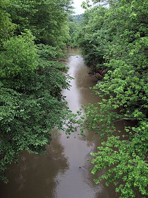
West Fork Little Kanawha River in Creston in 2009
|
|

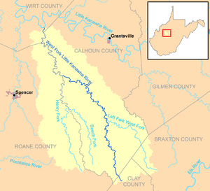
The West Fork Little Kanawha River and its watershed
|
|
| Country | United States |
| State | West Virginia |
| Counties | Clay, Calhoun, Roane, Wirt |
| Physical characteristics | |
| Main source | southwest of Nebo, northern Clay County 1,178 ft (359 m) 38°37′06″N 81°03′14″W / 38.6184296°N 81.0539982°W |
| River mouth | Little Kanawha River Creston, Wirt County 623 ft (190 m) 38°56′50″N 81°16′18″W / 38.9473052°N 81.2717844°W |
| Length | 48.1 mi (77.4 km) |
| Basin features | |
| Basin size | 246 sq mi (640 km2) |
| Tributaries |
|
The West Fork Little Kanawha River is a river in west-central West Virginia, United States. It is about 48 miles (77 kilometers) long. This river is a branch, or tributary, of the Little Kanawha River. Its waters eventually join the Little Kanawha River, then the Ohio River, and finally the mighty Mississippi River.
The West Fork Little Kanawha River drains an area of about 246 square miles (637 square kilometers). This area is mostly rural and part of the Allegheny Plateau. It is the second-largest tributary of the Little Kanawha River, after the Hughes River.
Contents
Where Does the River Start and Go?
The West Fork Little Kanawha River begins southwest of a community called Nebo. This is in the northern part of Clay County. From there, it flows generally toward the north-northwest.
Journey Through Counties and Towns
The river travels through Calhoun County. It also forms part of the border between Calhoun County and Roane and Wirt counties. Along its path, it passes through several small communities:
The river ends its journey at Creston in southeastern Wirt County. Here, it flows into the Little Kanawha River from the south.
Roads Along the River
For much of its upper part, before Arnoldsburg, the river runs alongside West Virginia Route 16. A bit downstream from Arnoldsburg, it is next to U.S. Route 33 for a short distance.
What Rivers Flow Into the West Fork?
The West Fork Little Kanawha River has its own smaller rivers and streams that flow into it. These are called tributaries.
- The Left Fork West Fork Little Kanawha River joins the West Fork at Orma.
- The Henry Fork flows into the West Fork where Roane and Calhoun counties meet.
What is the Land Like Around the River?
Most of the land around the West Fork Little Kanawha River is covered by forests. About 91% of the area that drains into the river is forested. These are mostly deciduous trees, which means they lose their leaves in the fall. The remaining 8.8% of the land is used for pastures and farming.
How Fast Does the River Flow?
The United States Geological Survey (USGS) has a special station at Rocksdale. This station measures how much water flows in the West Fork. It is located downstream from where the Henry Fork joins the river.
River Flow Records
Between 1928 and 2009, the highest amount of water recorded flowing in the river was 20,200 cubic feet per second (572 cubic meters per second). This happened on April 16, 1939. Sometimes, during certain years, the river even had periods where no water was flowing at all.
 | James Van Der Zee |
 | Alma Thomas |
 | Ellis Wilson |
 | Margaret Taylor-Burroughs |

