West Puente Valley, California facts for kids
Quick facts for kids
West Puente Valley, California
|
|
|---|---|

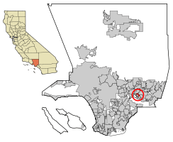
Location of West Puente Valley in Los Angeles County, California.
|
|
| Country | |
| State | |
| County | |
| Area | |
| • Total | 1.762 sq mi (4.564 km2) |
| • Land | 1.761 sq mi (4.562 km2) |
| • Water | 0.001 sq mi (0.002 km2) 0.05% |
| Elevation | 322 ft (98 m) |
| Population
(2020)
|
|
| • Total | 22,959 |
| • Density | 13,030/sq mi (5,030.5/km2) |
| Time zone | UTC-8 (PST) |
| • Summer (DST) | UTC-7 (PDT) |
| ZIP code |
91746
|
| Area code(s) | 626 |
| FIPS code | 06-84774 |
| GNIS feature ID | 1867073 |
West Puente Valley () is a community located in Los Angeles County, California, in the USA. It's a place where people live, but it's not an official city. It is found northwest of La Puente. In 2020, about 22,959 people lived there. The community's name likely comes from its location near the city of La Puente.
Contents
About West Puente Valley
West Puente Valley is a community in the middle of the San Gabriel Valley. It is located between Downtown Los Angeles and Pomona. Getting around is easy because major freeways are close by. These include the San Gabriel River Freeway to the west, the San Bernardino Freeway to the north, and the Pomona Freeway to the south.
This community is surrounded by other towns. To the south and east is La Puente. To the northwest is Baldwin Park. West Covina is to the northeast. To the west, you'll find the San Gabriel River Freeway and the edge of the City of Industry. West Puente Valley is mostly a place where homes are located. The ZIP codes for the area are 91744 and 91746.
Geography of West Puente Valley
West Puente Valley is located at 34°3′3″N 117°58′11″W / 34.05083°N 117.96972°W. This means it's in a specific spot on the map.
The community covers a total area of about 1.8 square miles (4.5 square kilometers). Almost all of this area is land, with only a tiny bit being water.
Population and People
West Puente Valley has grown over the years. Here's how the population has changed:
| Historical population | |||
|---|---|---|---|
| Census | Pop. | %± | |
| 1970 | 20,733 | — | |
| 1980 | 20,445 | −1.4% | |
| 1990 | 20,254 | −0.9% | |
| 2000 | 22,589 | 11.5% | |
| 2010 | 22,636 | 0.2% | |
Population in 2010
In 2010, West Puente Valley had 22,636 people living there. This means there were about 12,846 people per square mile.
Most people in West Puente Valley lived in homes. Only a small number lived in group housing or institutions.
There were 4,788 households in total. Many of these households, about 55%, had children under 18 living in them. Most households were married couples living together. Some households were led by a single parent. The average household had about 4.71 people.
The ages of people living in West Puente Valley varied. About 28% of the population was under 18 years old. Around 11% were 65 or older. The average age was 32.6 years.
Most homes were owned by the people living in them (about 81%). The rest were rented.
Population in 2000
In 2000, there were 22,589 people living in West Puente Valley. There were 4,834 households. The average household had 4.67 people.
About 32% of the population was under 18 years old. Around 9% were 65 or older. The average age was 29 years.
Schools in the Area
Students in West Puente Valley attend schools from two different school districts. The Bassett Unified School District serves the western part of the community. The Hacienda La Puente Unified School District serves the eastern part.
See also
 In Spanish: West Puente Valley para niños
 | Bessie Coleman |
 | Spann Watson |
 | Jill E. Brown |
 | Sherman W. White |


