Westerfield facts for kids
Quick facts for kids Westerfield |
|
|---|---|
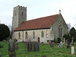
 Westerfield, Church of St Mary Magdalene |
|
| Area | 3.07 km2 (1.19 sq mi) |
| Population | 442 (2011) |
| • Density | 144/km2 (370/sq mi) |
| OS grid reference | TM1747 |
| District |
|
| Shire county | |
| Region | |
| Country | England |
| Sovereign state | United Kingdom |
| Post town | IPSWICH |
| Postcode district | IP6 |
| Dialling code | 01473 |
| Police | Suffolk |
| Fire | Suffolk |
| Ambulance | East of England |
| EU Parliament | East of England |
| UK Parliament |
|
Westerfield is a small village in Suffolk, England. It is located about two miles north of the center of Ipswich. The village is served by its own train station, Westerfield railway station, which is on the East Suffolk Line connecting Ipswich to Lowestoft.
Contents
What Can You Find in Westerfield?
Westerfield has a few places where people can gather and eat.
Places to Eat and Meet
The village has two local pubs: The Swan in the northern part of Westerfield and The Westerfield Railway in the south. Both of these places offer meals and are important spots for people in the village to meet and socialize.
The Village Green and Church
In the middle of Westerfield, there is a lovely village green. Right next to it is the historic St Mary Magdalene Church. This church is very old, dating back to medieval times. Inside, you can see beautiful stained glass windows. One famous window, called St Mary of Magdala, was designed by the well-known artist William Morris. A scholar named Cyprian Thomas Rust, who studied the Hebrew language, is buried here.
How Many People Live Here?
The number of people living in Westerfield changes over time.
Population Figures
In 2011, a census counted 442 people living in Westerfield. By 2019, the estimated population for Westerfield, including the nearby area of Culpho, was around 486 people.
See also
 In Spanish: Westerfield para niños
 | Valerie Thomas |
 | Frederick McKinley Jones |
 | George Edward Alcorn Jr. |
 | Thomas Mensah |


