Westford, Vermont facts for kids
Quick facts for kids
Westford, Vermont
|
|
|---|---|

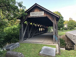
Westford Covered Bridge in 2019
|
|

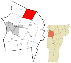
Location in Chittenden County and the state of Vermont.
|
|
| Country | United States |
| State | Vermont |
| County | Chittenden |
| Settled | 1763 |
| Chartered | June 8, 1763 |
| Named for | Being the westernmost of four simultaneously granted New Hampshire Grants |
| Communities | Westford Bowman Corners Cloverdale |
| Area | |
| • Total | 39.3 sq mi (101.8 km2) |
| • Land | 39.1 sq mi (101.2 km2) |
| • Water | 0.2 sq mi (0.5 km2) |
| Elevation | 472 ft (144 m) |
| Population
(2020)
|
|
| • Total | 2,062 |
| • Density | 53/sq mi (20.4/km2) |
| Time zone | UTC-5 (Eastern (EST)) |
| • Summer (DST) | UTC-4 (EDT) |
| ZIP codes | |
| Area code(s) | 802 |
| FIPS code | 50-80350 |
| GNIS feature ID | 1462251 |
Westford is a small and friendly town located in Chittenden County, Vermont, United States. In 2020, about 2,062 people lived here. Westford is known for its beautiful natural areas and quiet community feel. It's a great place to explore Vermont's history and enjoy the outdoors.
Contents
History of Westford
Early Days and Land Grants
Long ago, the land where Westford now stands was home to Native American tribes like the Sokoki, Missisquoi, and Cowasuck Abenaki. Sadly, new diseases and conflicts with English settlers caused many Native Americans to move away by the 1670s. This opened the land for European settlers.
Westford officially became a town on June 8, 1763. This happened when Governor Benning Wentworth of New Hampshire granted its charter. A charter is like an official permission slip to create a town. Westford was one of several towns granted at the same time, and it was named because it was the westernmost of these new towns.
When the town was created, some land was set aside for important things. Three lots were for religious use, one for the town's school, and two for the governor himself. The rest of the land was divided among the first families who settled there.
Land Disputes and Vermont's Independence
The land grants made by Governor Wentworth were not always clear. Another colony, New York, also claimed this area. From 1764 to 1770, courts decided that New York was the rightful owner of the land. This meant that the charters granted by New Hampshire, including Westford's, were no longer valid.
New York then tried to make settlers buy their land again from New York. The people of Westford and other towns protested this. They asked New York to confirm their original grants. Before a final decision could be made, the American Revolutionary War started in 1775.
In 1777, Vermont decided to become its own independent country, the Republic of Vermont. This meant it was no longer part of New York or England. Westford became a town within Vermont. In 1791, Vermont joined the United States as the 14th state, and Westford has been a part of Vermont's Chittenden County ever since.
Geography and Nature
Westford is located in the northern part of Chittenden County. It shares borders with Franklin and Lamoille counties to the north. The town covers about 101.8 square kilometers (about 39.3 square miles). Most of this area is land, with a small amount of water.
Waterways and Hills
Westford has several important waterways. These include Westford Pond, Pond Brook, Rogers Brook, and the Browns River. Morgan Brook runs through the center of town, and Beaver Brook is in the northeast.
The town also has many hills. Some are named after important families, like Duffy and Stewart hills. Others have descriptive names like Oak, Beech, Spruce, Bald, and Prospect hills. Some hills, like Number Eleven Hill, kept their original lot numbers. This might show that the early settlers weren't always happy with the quality of the land they received!
Communities in Westford
Westford has two main villages:
- Brookside: This community is located near Rogers Brook.
- Westford (or Westford Center): This is the main village, centered around the Westford Commons.
There are also smaller communities. These include Cloverdale, located near Vermont Route 15. Osgood Hill is named after an early settler. Bowman's Corners is just south of Brookside. There are also historic communities along the northern border with Fairfax, which grew because of early industries along the Lamoille River.
People and Population
Westford has grown quite a bit over the years. In 1790, only 63 people lived here. By 2020, the population had grown to 2,062 people.
Population Changes Over Time
| Historical population | |||
|---|---|---|---|
| Census | Pop. | %± | |
| 1790 | 63 | — | |
| 1800 | 648 | 928.6% | |
| 1810 | 1,107 | 70.8% | |
| 1820 | 1,025 | −7.4% | |
| 1830 | 1,290 | 25.9% | |
| 1840 | 1,352 | 4.8% | |
| 1850 | 1,458 | 7.8% | |
| 1860 | 1,231 | −15.6% | |
| 1870 | 1,237 | 0.5% | |
| 1880 | 1,133 | −8.4% | |
| 1890 | 1,033 | −8.8% | |
| 1900 | 888 | −14.0% | |
| 1910 | 854 | −3.8% | |
| 1920 | 706 | −17.3% | |
| 1930 | 698 | −1.1% | |
| 1940 | 698 | 0.0% | |
| 1950 | 685 | −1.9% | |
| 1960 | 680 | −0.7% | |
| 1970 | 991 | 45.7% | |
| 1980 | 1,413 | 42.6% | |
| 1990 | 1,740 | 23.1% | |
| 2000 | 2,086 | 19.9% | |
| 2010 | 2,029 | −2.7% | |
| 2020 | 2,062 | 1.6% | |
| U.S. Decennial Census | |||
According to the 2010 census, there were 2,029 people living in Westford. Most residents were White (97.2%). A small percentage were African American, Native American, Asian, or from other backgrounds. About 0.8% of the population was Hispanic or Latino.
Families and Age Groups
In 2010, there were 757 households in Westford. About 37.3% of these households had children under 18 living with them. The average household had 2.68 people.
The population of Westford is spread across different age groups. About 26.6% of the people were under 20 years old. Another 26.6% were between 25 and 44 years old. About 33.9% were between 45 and 64, and 8.8% were 65 or older. The average age in Westford was 41.5 years.
Economy and Jobs
Income in Westford
In Westford, the average income for a household was $81,574. For families, the average income was $84,423. The average income per person in the town was $34,502. A very small number of families (about 1.0%) and individuals (about 1.7%) lived below the poverty line.
Local Businesses and Industries
Westford's first industrial area was in the Village of Brookside. Around the early 1900s, Brookside had a post office, a cheese plant, and a factory that made cheese boxes. These businesses were run by the Rogers family.
Other businesses also grew along the northern border with Fairfax. There was a forge (a place where metal is shaped) that worked with iron ore from 1796 to 1810. The hamlet of Cloverdale also developed around the Cloverdale Creamery and a freight station for the Burlington and Lamoille Railroad.
Today, Westford is home to several businesses. These include Rovers North, which sells parts for Land Rover vehicles, and Morgan Brook Farm/Wagyu Wagon. There is also Kickback Brewery. Many businesses in Westford are professional services, agribusinesses (farming-related), transportation, and construction companies.
Famous People from Westford
Many interesting people have connections to Westford:
- Steven T. Byington (1869–1957): A smart thinker and translator who was born in Westford.
- Philo Judson Farnsworth (1832–1909): A doctor who was born in Westford.
- Seneca Haselton (1848–1921): He was a U.S. ambassador, a mayor, and a judge.
- Paul Languedoc (born 1958): A sound engineer for the famous band Phish. He used to live in Westford on property that later became The Barn, a recording studio owned by Trey Anastasio.
- Jonathan Mann (born 1982): A musician who grew up in Westford.
- Luke P. Poland (1815–1887): A United States senator and representative from Vermont, born in Westford.
- Torrey E. Wales (1820–1902): A lawyer and the second mayor of Burlington, Vermont, born in Westford.
- William Cleaver Wilkinson (1833–1920): A preacher, professor, and writer born in Westford.
See also
 In Spanish: Westford (Vermont) para niños
 | Valerie Thomas |
 | Frederick McKinley Jones |
 | George Edward Alcorn Jr. |
 | Thomas Mensah |


