Westport, Baltimore facts for kids
Quick facts for kids
Westport
|
|
|---|---|
|
Neighborhood of Baltimore
|
|

Westport, Baltimore, MD 21230, USA
|
|
| Country | United States |
| State | Maryland |
| City | Baltimore |
| Time zone | UTC-5 (Eastern) |
| • Summer (DST) | EDT |
| ZIP code |
21230
|
| Area code | 410, 443, and 667 |
Westport is a neighborhood in south Baltimore, Maryland. Most people living here are African-American. In the past, the neighborhood faced challenges like empty homes and people looking for jobs.
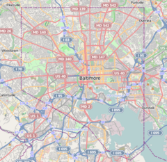
Westport is located by the Middle Branch of the Patapsco River to the east. To the southwest, it borders the neighborhoods of Cherry Hill, Brooklyn, and Lansdowne. To the west, you'll find Hollins Ferry Road and the Mount Winans and Lakeland neighborhoods. Interstate 95 is to the north, along with Federal Hill and Otterbein. The Baltimore–Washington Parkway (Maryland Route 295) also runs through Westport.
Contents
Westport's Past
Most homes in Westport are brick row houses built in the 1920s. They have small front porches. Many early residents were blue-collar workers. They worked at businesses near the waterfront. These included the Carr Lowrey Glass Company and the Constellation Energy's Baltimore Gas and Electric Company's Westport Generating Plant.
A railroad bridge for the old Western Maryland Railway and the Baltimore and Ohio Railroad crosses the Middle Branch. It runs through Westport. Over the years, many factories in Baltimore closed. Many people moved to the suburbs. This left neighborhoods like Westport needing repairs. Even after improvements in the 1970s, many shops closed. By 2000, many homes in Westport were empty.
When the Carr Lowrey Glass Company closed, its land was bought. Another company also bought the old Baltimore Gas & Electric power plant. Both old buildings were taken down. There were plans to build new things along the waterfront. These plans included a park, but they have been delayed.
Westport has a nice view of the Hanover Street Bridge and the Baltimore skyline. Because of the plans for new development, home prices in Westport went up. People hoped it would become a popular area like "the Next Canton."
In 1985, the Wheelabrator Incinerator was built north of Westport. This plant turns trash into energy. Its tall white smokestack says "Baltimore" and is a famous landmark. The Gwynns Falls Trail, a hiking and biking path, ends here.
Future Plans for Westport
In 2011, city leaders approved big plans for Westport's waterfront. Westport was chosen as a "BRAC Zone." This means it gets special benefits to attract businesses and jobs. The first new buildings were planned to be luxury apartments.
A new plan for Annapolis Road also started in 2011. This plan aimed to bring more businesses to Westport. Many groups worked together on these plans. These included the city, a developer named Patrick Turner, and the Westport Neighborhood Association.
However, Patrick Turner's plans faced problems. The land remained undeveloped. Many community leaders worked on this project. They also worked to address concerns about vapors from an old industrial site near homes.
Since then, the Westport Community Economic Development Corporation (CEDC) has worked with the Westport Neighborhood Association. They work with other groups to help the neighborhood. They also share local concerns about the waterfront plans.
In 2018, a report called the South Baltimore 7 Organizational Assessment and Strategic Planning Report was published. It talked about community goals. Later that year, several groups formed the Harbor West Collaborative. This group works together under the Westport CEDC. They meet often to plan for the community.
In 2019, a plan for the Westport Annapolis Road Corridor was released. It announced plans for road improvements. These improvements aim to make streets safer for walkers. They also want to help businesses and make the area more sustainable.
In early 2020, new planning efforts began. A collection of past plans and reports was put online. In December 2020, a company called Stonewall Capital showed its plans for the waterfront. Meetings also started for other nearby projects. More meetings will be announced by the Harbor West Collaborative.
Westport's People
In 2000, there were 2,185 people living in Westport. Most residents (88.8%) were African American. About 9.8% were White. Other groups made up smaller parts of the population. About 0.9% of people were Hispanic or Latino.
Many homes were owned by the people living in them (32.4%). However, many homes (22.0%) were empty. The neighborhood expects its population to change a lot with the new waterfront development.
About 34.6% of people had jobs. The average household income was $16,250.
Sports in Westport
Westport was once home to the Westport Raceway. This was a dirt track for stock car racing from the 1930s to the 1950s. Next to it was Westport Stadium, a baseball field. It was used by Negro leagues teams. The Baltimore Black Sox played there in the 1920s and early 1930s. Later, the Baltimore Elite Giants played there in the 1940s. The raceway and stadium were near Old Annapolis Road and Waterview Avenue. The Baltimore-Washington Parkway was built through Westport in the 1950s.
Westport was also the hometown of Al Kaline. He was a famous baseball player. He played high school baseball at Southern High School. After graduating in 1953, he was quickly signed by the Detroit Tigers. He started playing in the major leagues right away. He did not spend any time in the minor leagues. Al Kaline also coached the Westport Methodist Baseball League.
In 1953, the St. Louis Browns baseball team moved to Baltimore. They became the new Baltimore Orioles. Their first game in Baltimore was in April 1954. This was the season after Al Kaline started playing for the Tigers.
Getting Around Westport
Westport has a stop on Baltimore's Light Rail system. It's called the Westport Station. This light rail goes from Hunt Valley to BWI Airport.
The Westport stop is south of the Hamburg Street stop. That stop serves M&T Bank Stadium, home of the Baltimore Ravens football team. It also serves Oriole Park at Camden Yards, where the Baltimore Orioles baseball team plays. The Westport stop is north of the Cherry Hill neighborhood stop. Maryland Transit Administration buses also run along Old Annapolis Road (Maryland Route 648).
 | Stephanie Wilson |
 | Charles Bolden |
 | Ronald McNair |
 | Frederick D. Gregory |


