
Baltimore–Washington Parkway facts for kids
Quick facts for kids
|
||||
|---|---|---|---|---|
| Baltimore–Washington Parkway | ||||
| Lua error in Module:Infobox_road/map at line 15: attempt to index field 'wikibase' (a nil value).
MD 295 highlighted in red
|
||||
| Route information | ||||
| Maintained by NPS, MDSHA, Baltimore DOT | ||||
| Length | 32.52 mi (52.34 km) | |||
| Existed | 1950–present | |||
| Tourist routes |
||||
| Restrictions | No commercial vehicles south of MD 175 | |||
| Major junctions | ||||
| South end | ||||
|
||||
| North end | ||||
| Location | ||||
| Counties: | Prince George's, Anne Arundel, Baltimore, City of Baltimore | |||
| Highway system | ||||
| Maryland highway system Interstate • US • State • Minor • Former • Turnpikes
|
||||

The Baltimore–Washington Parkway (also called the B–W Parkway) is a major road in Maryland. It connects the cities of Baltimore and Washington, D.C.. This important highway starts near Cheverly in Prince George's County. It then heads northeast towards Baltimore.
Part of the parkway is managed by the National Park Service (NPS). This section is special because it does not allow large trucks. It is also dedicated to Gladys Spellman, a former representative from Maryland. This part of the road is officially known as Maryland Route 295 (MD 295), but you won't see signs for it here.
After the NPS section, the road is maintained by the state of Maryland. Here, you will see signs for MD 295, and trucks are allowed. This part of the parkway passes close to Baltimore–Washington International Thurgood Marshall Airport. When the parkway reaches Baltimore, the city's transportation department takes over. The parkway officially ends at Interstate 95 (I-95). MD 295 then continues north into downtown Baltimore as Russell Street. It follows Paca Street (northbound) and Greene Street (southbound) before ending at U.S. Route 40 (US 40).
The idea for this parkway began in the 1700s. But serious planning started in the 1920s. It was needed because another road, US 1, had many accidents. It was also important for national defense before World War II. Construction started in 1947 and the entire parkway opened in stages between 1950 and 1954. The parkway helped new neighborhoods grow around Washington and Baltimore. Over the years, parts of the parkway have been updated and widened to handle more traffic.
Contents
What is the Baltimore–Washington Parkway?
The National Park Service Section
The parkway starts near Washington, D.C. at a large interchange. Here, it connects with US 50 and MD 201. US 50 goes west into Washington, D.C. MD 201 goes north, running next to the parkway.
_at_the_exit_for_Maryland_State_Route_450_(Bladensburg,_Annapolis)_in_Landover,_Prince_George%27s_County,_Maryland.jpg)
The first part of the B–W Parkway is managed by the National Park Service (NPS). This section is six lanes wide and has brown signs. It is known as MD 295, but you won't see signs for it. Large trucks are not allowed here, but buses and limousines can use it. The parkway goes through wooded areas and passes over railroad tracks. It has exits for roads like MD 202 and MD 450. These exits lead to towns like Cheverly and Bladensburg. Bladensburg is a historic town with old houses.
The parkway then becomes four lanes wide with a wide, tree-filled area in the middle. It passes through forests, hiding nearby neighborhoods. It connects with MD 410, which leads to Riverdale Park and Hyattsville. Riverdale Park has an old mansion from 1801. Hyattsville has buildings from the 1870s.
Next, the parkway enters Greenbelt, a planned community from the 1930s. It also goes through Greenbelt Park, an NPS park where you can camp. In this park, the parkway meets I-95 and I-495, which is called the Capital Beltway. This is the only place where the NPS uses green road signs.

After the Capital Beltway, the parkway enters the town of Greenbelt. It has an exit for MD 193 (Greenbelt Road). The U.S. Park Police headquarters are near this exit. MD 193 also leads to College Park. This town is home to the College Park Airport, where the Wright brothers taught flying. It also has the University of Maryland.
Further north, there's an employee-only entrance to the Goddard Space Flight Center. This was the first NASA space center, opened in 1958. The parkway then enters the Beltsville Agricultural Research Center. This is the world's largest agricultural research center. The only exit here is for Powder Mill Road.
The parkway then passes MD 197 (Laurel–Bowie Road) near Laurel. Close by is the Montpelier Mansion, built in 1783. After MD 197, the road goes through the Patuxent Wildlife Research Center. This wildlife refuge was created in 1936. It then crosses the Patuxent River into Anne Arundel County. Here, the parkway continues through thick woods. It has an exit for MD 198 (Fort Meade Road). Laurel is a suburb with many historic sites, like the Laurel Railroad Station.
_just_south_of_Maryland_State_Route_175_(Jessup_Road)_in_Jessup,_Anne_Arundel_County,_Maryland.jpg)
Next, the parkway meets MD 32 (Savage Road) near Fort Meade. MD 32 gives direct access to Fort Meade and the National Security Agency. Fort Meade is a large military base that opened in 1917. Near MD 32 is the Savage Mill, an old cotton mill now an antique mall. There's also the Bollman Truss Railroad Bridge, an old iron bridge from 1869. After this, the NPS section of the parkway ends at MD 175 (Jessup Road).
The Maryland Route 295 Section
_just_north_of_Maryland_State_Route_175_(Jessup_Road)_in_Severn,_Anne_Arundel_County,_Maryland.jpg)
After the MD 175 exit, you will see signs for MD 295. This part of the road is maintained by the Maryland State Highway Administration. It is a four-lane freeway, and trucks are allowed here. This helps trucks get to Fort Meade and BWI Airport. The signs here are green, like on most highways.
The road continues through wooded areas. It has a special type of interchange called a diverging diamond interchange with MD 713F (Arundel Mills Boulevard). This exit leads to the Arundel Mills shopping mall and the Live! Casino & Hotel. After this, MD 295 meets MD 100.
The route then curves northwest around Baltimore–Washington International Airport (BWI Airport). BWI is the largest airport in Maryland. The parkway then reaches I-195, which is the main road to the airport. I-195 westbound also leads to the Thomas Viaduct, an old railroad bridge, and Patapsco Valley State Park. This state park is huge, covering about 14,000 acres.
The parkway widens to six lanes and meets West Nursery Road near Linthicum. This area has many hotels near BWI. After West Nursery Road, the parkway connects with I-695, which is the Baltimore Beltway. The route then goes under MD 168 (Nursery Road). It then crosses the Patapsco River into Baltimore County.
In Baltimore County, MD 295 has a partial interchange with I-895 (Harbor Tunnel Thruway). This means you can only make certain turns here. The road continues through woods with houses hidden behind the trees. Then, it enters the city of Baltimore.
In Baltimore, MD 295 is still a freeway. It is maintained by the Baltimore Department of Transportation. It passes under railroad tracks and has an interchange with MD 648 (Annapolis Road) and Waterview Avenue. The parkway then heads north over another railroad line. It reaches its northern end at I-95. At this point, MD 295 changes from a freeway to a six-lane city street called Russell Street.
_near_West_Camden_Street_in_downtown_Baltimore_City,_Maryland.jpg)
MD 295 continues north on Russell Street, but you won't see signs for it anymore. It passes industrial and business areas. It goes by the Horseshoe Casino Baltimore and M&T Bank Stadium, where the Baltimore Ravens play football. Further north, it has an interchange with Martin Luther King Jr. Boulevard. This road becomes I-395 to the south.
After this, MD 295 runs west of Oriole Park at Camden Yards. This is where the Baltimore Orioles baseball team plays. MD 295 then splits into a one-way pair. Northbound traffic follows Paca Street, and southbound traffic follows Greene Street. Along these streets, the route crosses many main roads in downtown Baltimore.
Greene Street passes the University of Maryland Medical Center. Paca Street passes several historic buildings. MD 295 finally ends at US 40 in downtown Baltimore. MD 129 continues north from this point.
History of the Parkway
Early Planning and Construction
The idea for a road connecting Baltimore and Washington, D.C., goes back to the 1700s. But serious plans started in the 1920s. In 1924, Harry W. Nice, who later became Governor of Maryland, pushed for the parkway.
Early ideas included following US 1. But there wasn't enough money, so they just widened US 1 instead. In the 1930s, President Franklin D. Roosevelt's New Deal programs brought more attention to the parkway idea. A 1937 report also highlighted the need for it. US 1 had many accidents and was considered very dangerous. Also, before World War II, there was a need for better roads to move military supplies. These reasons made building the parkway even more important.
In 1942, the government started designing the parkway. They hired a company to create the plans. The southern end would connect to New York Avenue in Washington. The northern end would connect to US 40 in Baltimore. These plans were finalized in 1945.
Construction on the northern part of the highway began in 1947 by the state of Maryland. The NPS section started in 1950. The land for the NPS part was bought at the same time as Greenbelt Park. The state-maintained part was finished in stages between 1950 and 1952. The part within Baltimore city opened in 1951. The NPS-maintained section opened in October 1954. The state part was called the Baltimore–Washington Expressway. The NPS part was called the Baltimore–Washington Parkway.
After Construction and Modernization
After the highway was finished, the government encouraged people to move to the suburbs. They moved some federal offices out of Washington, D.C. This led to new neighborhoods growing in towns like Laurel and Greenbelt. The parkway became a popular route for people commuting to work in Washington and Baltimore. This growth eventually made the two cities feel like one big metropolitan area.
In the 1960s, there were talks about giving the NPS part of the parkway to the state. The state would then upgrade it to a modern freeway, allowing trucks. But the state didn't want to pay for the expensive upgrades. The NPS section was one of the most dangerous roads in their system.
In 1965, the Goddard Space Flight Center built its employee entrance.
_just_south_of_Interstate_695_(Baltimore_Beltway)_in_Linthicum,_Anne_Arundel_County,_Maryland.jpg)
In 1968, there was a proposal to make the parkway part of the Interstate Highway System. It would be called Interstate 295 (I-295). This was approved in 1969, but later canceled for most of the road due to lack of money. So, the parkway remained unnumbered south of I-695. The part north of I-695 became part of MD 3 by 1975. Even with this setback, plans to widen the parkway continued. But there wasn't enough money. There was also a chance to route I-95 along the parkway, but this didn't happen. Trucks were banned from the parkway again.
By 1973, MD 3 was assigned to the Baltimore–Washington Expressway. By 1981, MD 295 was assigned to the state-maintained parts, replacing MD 3. By the 1990s, the whole road became known as the Baltimore–Washington Parkway.
In the mid-1980s, the National Park Service started rebuilding its section. They improved several interchanges. This project finished around 2002.
In 2004, Maryland Governor Robert L. Ehrlich announced plans to widen parts of MD 295 near BWI Airport. The road was widened from two lanes to three lanes in each direction between I-195 and I-695. This project started in 2008 and finished in 2011.
In 2012, the interchange at Arundel Mills Boulevard was rebuilt. It became Maryland's first diverging diamond interchange. This was part of a $5 million upgrade for the Maryland Live! casino.

Dedications and Future Plans
In 1983, the NPS section of the parkway was named after Gladys Noon Spellman. She was a congresswoman from Maryland from 1975 to 1981. Gladys Spellman was an educator and the first woman on Prince George's County's Board of Commissioners. She had a heart attack in 1980 and passed away in 1988. On May 9, 1991, the Baltimore–Washington Parkway was added to the National Register of Historic Places.
There are plans to widen MD 295 to six lanes between MD 100 and I-195. A new interchange is also planned at Hanover Road.
In 2017, Governor Larry Hogan announced a plan to add four more lanes to the Baltimore–Washington Parkway. These would be express toll lanes in the middle of the road. This project would involve private companies building and managing the lanes. As part of this plan, the NPS part of the parkway would be given to the Maryland Transportation Authority.
By 2019, parts of the NPS section of the parkway had many potholes. In March 2019, the speed limit was lowered on a section due to poor road conditions. After pressure from the governor, the National Park Service announced emergency repairs. A full repaving started in April 2019, ahead of schedule.
Exit List
| County | Location | Mile |
Roads intersected | Notes | |
|---|---|---|---|---|---|
| Prince George's | Tuxedo | 0.00 | 0.00 | Southern end of MD 295 and Baltimore–Washington Parkway | |
| 0.79 | 1.27 | Northbound exit and southbound entrance only | |||
| Bladensburg | 1.65 | 2.66 | |||
| 1.97 | 3.17 | ||||
| | 3.63 | 5.84 | |||
| Greenbelt Park | 5.99 | 9.64 | |||
| Greenbelt | 6.36 | 10.24 | |||
| 7.53 | 12.12 | Goddard Space Flight Center (employees only) | |||
| South Laurel | 9.65 | 15.53 | Powder Mill Road – Beltsville | ||
| | 11.51 | 18.52 | |||
| Anne Arundel | | 14.86 | 23.91 | ||
| | 16.61 | 26.73 | Exits 10B-C on MD 32; access to Canine Road via MD 295 north only; serves National Cryptologic Museum | ||
| | 17.04 | 27.42 | NSA (restricted entrance) | Southbound exit and northbound entrance only | |
| | 18.56 | 29.87 | NPS–MDSHA boundary | ||
| | 18.81 | 30.27 | Access to Jessup MARC Station via MD 175 west; commercial vehicles must exit here | ||
| | 20.05 | 32.27 | Arundel Mills Boulevard (MD 713F) | Diverging diamond interchange; access to Live! Casino & Hotel | |
| | 21.31 | 34.30 | Exits 10A-B on MD 100 | ||
| | 24.21 | 38.96 | Exits 2A-B on I-195; formerly MD 46 | ||
| | 25.42 | 40.91 | West Nursery Road – BWI Hotel District | ||
| Linthicum | 26.59 | 42.79 | Exits 7A-B on I-695, access to Key Bridge | ||
| Baltimore | | 27.66 | 44.51 | Northbound exit and southbound entrance; no exit before toll on I-895 | |
| | 28.88 | 46.48 | Baltimore city line (MDSHA–Baltimore DOT boundary) | ||
| Baltimore City | 29.89 | 48.10 | Southbound exit and entrance only | ||
| Waterview Avenue | Northbound exit and entrance, access to Cherry Hill station | ||||
| 30.11 | 48.46 | Westport | Via Wenburn Street (northbound) or Manokin Street (southbound), access to Westport Light Rail station | ||
| 30.53 | 49.13 | Same-directional movements only | |||
| 30.53 | 49.13 | ||||
| 30.53 | 49.13 | Northern end of Baltimore–Washington Parkway; southern end of Russell Street | |||
| 31.52 | 50.73 | Northbound exit and southbound entrance (except Hamburg Street) | |||
| 32.45 | 52.22 | ||||
| 32.52 | 52.34 | Northern end of MD 295 | |||
| 1.000 mi = 1.609 km; 1.000 km = 0.621 mi | |||||
Images for kids
-
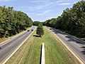
Baltimore–Washington Parkway northbound in Greenbelt
-
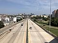
Northbound at the north end of the parkway entering downtown Baltimore
_from_the_Spellman_Overpass_in_Greenbelt,_Prince_George%27s_County,_Maryland.jpg)
_from_the_overpass_for_the_ramp_from_southbound_Interstate_95_to_southbound_Maryland_State_Route_295_in_Baltimore_City,_Maryland.jpg)
