
Whakaari / White Island facts for kids
Quick facts for kids Whakaari / White Island |
|
|---|---|
| Whakaari (Māori) | |

Whakaari / White Island seen from the south
|
|
| Highest point | |
| Elevation | 321 m (1,053 ft) |
| Prominence | 321 m (1,053 ft) |
| Geography | |
| Location | Bay of Plenty, (off) North Island, New Zealand |
| Geology | |
| Mountain type | Stratovolcano |
| Volcanic arc/belt | Taupō Volcanic Zone |
| Last eruption | 9 December 2019 |
Whakaari / White Island ([faˈkaːɾi]), also known as White Island or Whakaari, is an active volcano in New Zealand. It is located about 48 kilometers (30 miles) off the east coast of the North Island, in the Bay of Plenty. The island is the top part of a much bigger volcano that is mostly underwater.
This island is New Zealand's most active cone volcano. It has been growing from volcanic activity for about 150,000 years. The closest towns on the mainland are Whakatāne and Tauranga. Whakaari has been letting out volcanic gas almost constantly since 1769. It erupted many times between 1975 and 2000, and also in 2012, 2016, and 2019.
People used to mine sulphur on the island until the 1930s. Today, the main activities are guided tours and scientific research. You can only visit the island with a registered tour group.
A large eruption happened on December 9, 2019. Sadly, 22 people died, and 25 others were seriously hurt. Many had severe burns. Three people had minor injuries. There were 47 people on the island when the volcano erupted. A second, smaller eruption happened soon after the first.
Contents
About Whakaari / White Island
Whakaari / White Island is shaped like an uneven oval. It is about 3 kilometers (1.9 miles) long and 2 kilometers (1.2 miles) wide. The island covers an area of about 325 hectares (800 acres). It sits in the Bay of Plenty, 48 kilometers (30 miles) from the North Island. It is north of Ōpōtiki and north-northeast of Whakatāne.
The volcano's active crater is a bit southeast of the island's center. This crater holds an acidic lake. The crater has a sharp edge to the northwest. The highest point of the island, Mount Gisborne, is 321 meters (1,053 feet) high and is on this western edge. Mount Percival, 283 meters (928 feet) high, forms the northern part of the rim. An older volcano opening, Mount Ngatoro, is 310 meters (1,017 feet) high and lies to the northwest.
The part of the island you can see is just the very top of a much larger volcano. This underwater volcano rises up to 1,600 meters (5,200 feet) from the seafloor.
The island is mostly rough and rocky, with cliffs along most of its coast. The only flatter areas are southeast of the crater. Here, ash and rock slopes go down to Te Awapuia Bay. This bay is where old buildings and the island's dock are located.
How the Island Formed
Whakaari / White Island is a type of volcano called a stratovolcano. It is made of two volcanoes that overlap: the Ngatoro Cone and the Central Cone. The Ngatoro Cone is no longer active and has partly worn away. The Central Cone is the active part of the volcano.
The crater of the Central Cone is open to the southeast. This happened because of big landslides in the past. The Ngatoro and Central cones are built from layers of hardened lava, ash, and rocks. Some of these layers have been changed by hot, acidic fluids and gases from inside the volcano.
The bottom of Whakaari / White Island's main crater is less than 30 meters (98 feet) above sea level. It is mostly covered by material from a landslide that happened in 1914. The main crater has three smaller craters inside it.
Whakaari / White Island and the nearby Club Rocks and Volckner Rocks are the visible tops of a much larger underwater volcano. This volcano is called White Island Volcano. It is about 16 kilometers (9.9 miles) by 18 kilometers (11 miles) wide.
Scientists believe the Central Cone's crater was formed when the volcano's older cone collapsed. This collapse might have caused a large tsunami (a giant wave) about 3,000 to 2,200 years ago. This tsunami could have been 7 meters (23 feet) high and flooded the coast of the Bay of Plenty up to 7 kilometers (4.3 miles) inland.
Volcano Activity

Whakaari / White Island is at the northern end of the Taupō Volcanic Zone. This zone is a long chain of volcanoes that stretches for 2,800 kilometers (1,700 miles).
For thousands of years, Whakaari / White Island has had a very active system of hot water and gases. This system creates hot springs, mud pools, and steam vents called fumaroles. The main area of volcanic activity today is a large crater lake filled with boiling acidic water. This lake's size changes depending on the weather and how active the volcano is.
Most eruptions at Whakaari / White Island are called "phreatic" or "phreatomagmatic." This means they are caused by steam and gas explosions, often when hot magma meets water. Since 1826, there have been at least 28 such eruptions.

Scientists called volcanologists from the GeoNet Project constantly watch the volcano. They use cameras, special measuring tools, and equipment to detect earthquakes. Most of the time, the volcano only releases steam and boiling mud. But gas and ash are also common. The island is usually at an alert level of 1 or 2 (out of 0 to 5). Level 2 means there is "moderate to heightened volcanic unrest" and a "potential for eruption hazards."
In March 2000, three new openings appeared in the main crater. They started releasing ash, covering the island in a fine grey powder. An eruption on July 27, 2000, covered the island with mud and rocks. A new crater also appeared. Big eruptions in 1981–83 changed a lot of the island's landscape. They destroyed a large forest of pōhutukawa trees. The big crater created then now holds a lake, which changes its water level often.
In July and August 2012, the island showed more activity. The lake and gas levels inside the crater rose. On August 5, 2012, a small eruption sent ash into the air. More eruptions have happened since then.
On January 25, 2013, ongoing volcanic activity suggested another eruption was coming. A small eruption happened on August 20, 2013, lasting ten minutes and mostly producing steam.
2019 Eruption
In November 2019, the volcano became more active. Gas, steam, and mud were being thrown out from the crater.

At 2:11 PM on December 9, 2019, Whakaari / White Island erupted. Forty-seven people were reported to be on the island at that time. Sadly, 22 people died, and 25 others were seriously injured. Many of the injured had critical burns. Rescue efforts were difficult because of ongoing volcanic activity, heavy rain, poor visibility, and toxic gases.
Experts said it was a "phreatic eruption." This means it was an explosion of steam and volcanic gases. It launched rocks and ash into the air. Small ash releases were seen on December 23 and 26, but no more large eruptions happened. In January, observations showed that new lava had been pushed into the openings created by the December 9 eruption.
History of the Island

Name
The Māori name Whakaari has been written in European texts since 1849. The name Whakaari means "to make visible" or "exposed to view." The full Māori name for the island is te puia whakaari, which means "The Dramatic Volcano."
Captain Cook named the island "White Island" on October 1, 1769. This name likely came from the thick white steam clouds coming from it. Another idea is that he was referring to the white bird droppings (guano) that used to cover the island. Even though Cook sailed close to the island, he did not write down that it was a volcano.
The island's official name was changed to "Whakaari / White Island" in 1997. This makes it one of many places in New Zealand with both a Māori and an English name.
Māori Stories
Some Māori stories say Whakaari is linked to the journey of Ngātoro-i-rangi up Mount Tongariro. In one story, he asked his ancestors for warmth. The fire was lit on Whakaari and brought to him. Other versions say his sisters or the gods sent him warmth from Whakaari.
Other stories explain how the island came to be. One story says it rose from the deep ocean after the god Maui was burned by fire. He dived underwater to cool his pain, and where he shook off the fire, Whakaari appeared. Another story tells that Moutohora Island and Whakaari / White Island were once mountains near Waikaremoana. They were jealous of each other and raced to the ocean. Whakaari was faster and got to the best spot where it is today.
Sulphur Mining

People tried to mine sulphur from Whakaari / White Island several times. This happened in the mid-1880s, from 1898 to 1901, and again from 1913 to 1914. Mining stopped in September 1914 when part of the western crater rim collapsed. This caused a mudslide that killed all 10 workers. They disappeared without a trace. Only a camp cat survived. It was found days later by a supply ship and called "Peter the Great."
In 1923, mining was tried again. This time, the miners built their huts on a flat part of the island, away from the dangerous crater. They would lower their boat into the sea each day and row to the mining factory. If the sea was rough, they had to climb along a very narrow path on the crater's edge.
Before antibiotics were common, sulphur was used in medicines to fight bacteria. It was also used to make match-heads and to clean wine corks. The sulphur was taken to a crushing plant in small rail cars. A bagging facility was also built. However, the sulphur from the island was not pure enough. So, the crushed rock was used as part of fertilizer for farms. Mining ended in the 1930s because the fertilizer did not have enough good minerals. The remains of the old buildings can still be seen today. They are heavily rusted by the volcano's acidic gases.
Ownership
The ownership of Whakaari / White Island was one of the first cases heard by the Māori Land Court. In 1867, Retireti Tapihana (Tapsell) claimed ownership. He and his sister, Katherine Simpkins, were given joint ownership.
In 1874, the island was sold to John Wilson and William Kelly. They later leased it to another company.
Today, the island is privately owned by the Buttle Family Trust. George Raymond Buttle, a stockbroker, bought it in 1936. He later refused to sell it to the government. But in 1952, he agreed for it to be called a private scenic reserve.
Animals and Plants
Whakaari / White Island is one of New Zealand's main places where Australasian gannets breed. Thousands of gannets come to the island every year. They mate, raise their chicks, and eat fish from the surrounding waters. There are not many plants on the island itself. However, seaweed grows in the water around it. Gannet parents collect this seaweed to help cool their chicks.
An expert who visited in 1912 found five types of birds. Besides gannets, they saw red-billed gulls, great-winged petrels, and white-fronted terns.
BirdLife International has named the island an Important Bird Area. This is because of the large gannet nesting colony there.
Visiting the Island


Whakaari / White Island is privately owned. It was made a private scenic reserve in 1953. This means visitors cannot land without permission. However, it is easy to visit with approved tour operators.
The waters around the island are known for their many fish. Yellowtail kingfish are found all year. In winter, you can fish in deep water for hapuka and bluenose. In summer, blue, black, and striped marlin, as well as yellowfin tuna, can be caught. Small boats offer day trips and longer trips from the nearby port at Whakatāne.
On-land tours of the island have not been running since the 2019 eruption.
Images for kids
-
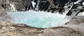
The crater lake in 2004
-
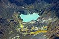
Aerial view of the crater lake in 2005


See also
 In Spanish: Isla Whakaari/White para niños
