Whakatāne facts for kids
Quick facts for kids
Whakatāne
|
|
|---|---|
|
Town
|
|
 |
|
| Motto(s):
Everything under the sun
|
|
| Country | New Zealand |
| Region | Bay of Plenty |
| Territorial authority | Whakatāne District |
| Ward | Whakatāne-Ōhope General Ward |
| Community | Whakatāne-Ōhope Community |
| Settled by Māori | c. 1200 |
| Electorates |
|
| Area | |
| • Territorial | 24.41 km2 (9.42 sq mi) |
| Population
(June 2023)
|
|
| • Territorial | 16,850 |
| • Density | 690.3/km2 (1,787.8/sq mi) |
| Time zone | UTC+12 (NZST) |
| • Summer (DST) | UTC+13 (NZDT) |
| Postcode(s) |
3120
|
| Area code(s) | 07 |
| Website | https://www.whakatane.govt.nz/ |
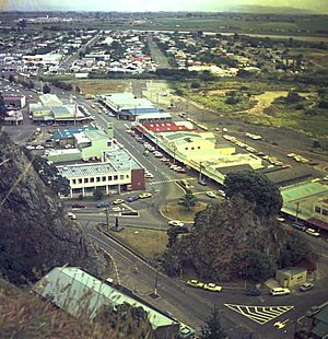
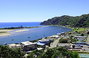
Whakatāne (pronounced fah-kah-TAH-nay) is a town in the Bay of Plenty Region on New Zealand's North Island. It is about 90 kilometers east of Tauranga and 89 kilometers northeast of Rotorua. The town sits where the Whakatāne River meets the sea. The wider Whakatāne District includes the town and surrounding areas.
Whakatāne is home to about 15,795 people. This makes it the 33rd largest urban area in New Zealand. It is also the third largest in the Bay of Plenty, after Tauranga and Rotorua. Many people in Whakatāne have Māori roots (around 42%). About 66% have European/Pākehā roots. Some people identify with more than one group.
Whakatāne is part of the East Coast area for New Zealand's parliament. The town is the main center for the eastern Bay of Plenty. This area includes Whakatāne, Kawerau, and Ōpōtiki. Whakatāne is also where the Bay of Plenty Regional Council meets. This location was chosen as a fair spot between the bigger cities of Tauranga and Rotorua.
Contents
History and Culture in Whakatāne
Early Māori Settlement
People have lived in Whakatāne for a very long time. Māori pā (fortified villages) in the area date back to around 1200 CE. This was when the first Polynesian settlers arrived.
Māori stories say that Toi-te-huatahi, also known as Toi-kai-rakau, came to Whakatāne around 1150 CE. He was looking for his grandson, Whatonga. When he couldn't find him, Toi settled here. He built a pā on the highest part of the headland, which is now called Whakatāne Heads. About 200 years later, the Mātaatua canoe landed in Whakatāne.
The Māori name Whakatāne comes from a famous event after the Mataatua arrived. The men had gone ashore, and the canoe started to drift away. Wairaka, a brave chieftainess, said, "Kia whakatāne au i ahau" (meaning "I will act like a man"). She started to paddle, even though women were not usually allowed to. With help from other women, the canoe was saved. A bronze statue of Wairaka was put up in 1965 at the mouth of the Whakatāne River to remember her actions.
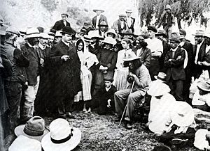
The Whakatāne area was important during the New Zealand Wars in the mid-1800s. There were attacks by Te Kooti's forces in 1869. Many buildings were burned down. A historic meeting happened on Whakatāne beach on March 23, 1908. Prime Minister Joseph Ward met with the Māori leader Rua Kenana Hepetipa.
Growth of European Settlement
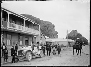
From 1880, Whakatāne became a key center for building ships and trading. The town grew a lot after 1904. This was when the Rangitāiki swamp was drained to create good farmland. In the early 1920s, Whakatāne was one of the fastest-growing towns in the country. This growth brought electricity to the town for the first time. A factory that makes carton board started in Whakatāne in 1939 and is still working today.
The Whakatāne River used to be much longer and windier. In the 1960s, parts of the river were changed to help stop floods and allow the town to grow. Some parts of the old river remain as Lake Sullivan and the Awatapu lagoon. The old bridge at Bridge Street, built in 1911, was taken down in 1984. It was replaced by the Landing Road bridge.
Whakatāne has become a popular place to live and retire. It is also a main center for many smaller towns nearby.
Mataatua Declaration
An important meeting called the 'First International Conference on the Cultural and Intellectual Property Rights of Indigenous Peoples' was held in Whakatāne. This happened from June 12 to 18, 1993. From this meeting came the Mataatua Declaration. This document is about protecting the cultural and intellectual rights of Indigenous peoples.
Marae: Important Meeting Places
Whakatāne has five marae. These are special meeting places for the Ngāti Awa hapū (sub-tribes). They are very important for Māori culture and community life.
- Te Hokowhitu a Tū ki te Rāhui Marae and Te Hokowhitu a Tūmatauenga meeting house.
- Te Rangihouhiri II Marae and Te Rangihouhiri II meeting house.
- Tokitareke or Warahoe Marae and Te Puna o Te Orohi meeting house.
- Toroa or Pupuaruhe Marae and Toroa meeting house.
- Te Whare o Toroa Marae and Wairaka meeting house.
In 2020, the New Zealand Government helped fund upgrades for these marae. This created jobs and supported the local community.
Whakatāne's Geography and Climate
Natural Surroundings
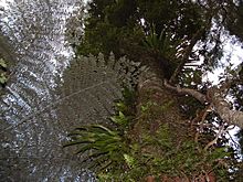
Moutohora Island is a small island about 12 kilometers north of Whakatāne. It has old Māori pā sites. Captain James Cook's ship, Endeavour, found shelter there in 1769.
Whakaari/White Island is an active volcano in the sea. It is about 48 kilometers offshore from Whakatāne. It used to be a popular place for visitors.
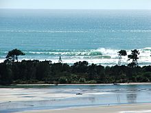
The mouth of the Whakatāne River and Ohiwa Harbour have always been used by boats. These include yachts, fishing boats, and small ships. Nearby Ōhope Beach is a long sandy beach, stretching 11 kilometers.
Whakatāne's Weather
Whakatāne often has the most sunshine hours in New Zealand each year. Since 2008, the town has often had over 2600 hours of sunshine a year. In 2013, it had an average of more than 7.5 hours of sunshine every day. Whakatāne also often records the highest daily temperature in the country.
| Climate data for Whakatāne (1991–2020 normals, extremes 1947–present) | |||||||||||||
|---|---|---|---|---|---|---|---|---|---|---|---|---|---|
| Month | Jan | Feb | Mar | Apr | May | Jun | Jul | Aug | Sep | Oct | Nov | Dec | Year |
| Record high °C (°F) | 34.4 (93.9) |
36.4 (97.5) |
31.0 (87.8) |
29.6 (85.3) |
24.5 (76.1) |
21.1 (70.0) |
20.0 (68.0) |
22.0 (71.6) |
24.4 (75.9) |
28.2 (82.8) |
32.1 (89.8) |
32.1 (89.8) |
36.4 (97.5) |
| Mean maximum °C (°F) | 29.2 (84.6) |
28.8 (83.8) |
26.3 (79.3) |
23.9 (75.0) |
20.7 (69.3) |
18.3 (64.9) |
17.2 (63.0) |
18.0 (64.4) |
20.4 (68.7) |
23.1 (73.6) |
25.5 (77.9) |
26.9 (80.4) |
30.3 (86.5) |
| Mean daily maximum °C (°F) | 24.3 (75.7) |
24.5 (76.1) |
22.9 (73.2) |
20.3 (68.5) |
17.6 (63.7) |
15.1 (59.2) |
14.4 (57.9) |
15.2 (59.4) |
16.7 (62.1) |
18.5 (65.3) |
20.4 (68.7) |
22.5 (72.5) |
19.4 (66.9) |
| Daily mean °C (°F) | 19.2 (66.6) |
19.5 (67.1) |
17.6 (63.7) |
14.9 (58.8) |
12.3 (54.1) |
9.9 (49.8) |
9.3 (48.7) |
10.0 (50.0) |
11.7 (53.1) |
13.6 (56.5) |
15.4 (59.7) |
17.9 (64.2) |
14.3 (57.7) |
| Mean daily minimum °C (°F) | 14.2 (57.6) |
14.5 (58.1) |
12.3 (54.1) |
9.6 (49.3) |
7.0 (44.6) |
4.6 (40.3) |
4.1 (39.4) |
4.7 (40.5) |
6.8 (44.2) |
8.7 (47.7) |
10.4 (50.7) |
13.2 (55.8) |
9.2 (48.5) |
| Mean minimum °C (°F) | 7.6 (45.7) |
8.3 (46.9) |
6.0 (42.8) |
2.6 (36.7) |
0.4 (32.7) |
−1.1 (30.0) |
−1.4 (29.5) |
−1.1 (30.0) |
0.5 (32.9) |
2.2 (36.0) |
3.8 (38.8) |
6.7 (44.1) |
−2.0 (28.4) |
| Record low °C (°F) | 3.0 (37.4) |
3.5 (38.3) |
1.2 (34.2) |
−1.1 (30.0) |
−1.8 (28.8) |
−4.1 (24.6) |
−4.0 (24.8) |
−3.3 (26.1) |
−2.0 (28.4) |
−1.3 (29.7) |
0.2 (32.4) |
0.4 (32.7) |
−4.1 (24.6) |
| Average rainfall mm (inches) | 72.4 (2.85) |
79.6 (3.13) |
87.0 (3.43) |
122.1 (4.81) |
117.9 (4.64) |
130.4 (5.13) |
136.1 (5.36) |
105.5 (4.15) |
88.6 (3.49) |
92.7 (3.65) |
63.8 (2.51) |
99.7 (3.93) |
1,195.8 (47.08) |
| Mean monthly sunshine hours | 270.2 | 230.5 | 233.9 | 192.9 | 174.5 | 137.8 | 148.7 | 182.9 | 184.3 | 225.7 | 237.2 | 248.0 | 2,466.6 |
| Mean daily daylight hours | 14.5 | 13.5 | 12.3 | 11.1 | 10.1 | 9.6 | 9.8 | 10.7 | 11.9 | 13.1 | 14.2 | 14.7 | 12.1 |
| Percent possible sunshine | 60 | 60 | 61 | 58 | 56 | 48 | 49 | 55 | 52 | 56 | 56 | 54 | 55 |
| Source 1: NIWA | |||||||||||||
| Source 2: Weather Spark | |||||||||||||
| Climate data for Whakatāne (Ōhope) (1981–2010) | |||||||||||||
|---|---|---|---|---|---|---|---|---|---|---|---|---|---|
| Month | Jan | Feb | Mar | Apr | May | Jun | Jul | Aug | Sep | Oct | Nov | Dec | Year |
| Mean daily maximum °C (°F) | 23.8 (74.8) |
24.3 (75.7) |
22.8 (73.0) |
20.3 (68.5) |
17.7 (63.9) |
15.4 (59.7) |
14.9 (58.8) |
15.5 (59.9) |
16.9 (62.4) |
18.4 (65.1) |
20.0 (68.0) |
22.0 (71.6) |
19.3 (66.8) |
| Daily mean °C (°F) | 19.5 (67.1) |
20.1 (68.2) |
18.5 (65.3) |
16.0 (60.8) |
13.5 (56.3) |
11.2 (52.2) |
10.6 (51.1) |
11.1 (52.0) |
12.7 (54.9) |
14.2 (57.6) |
15.9 (60.6) |
18.0 (64.4) |
15.1 (59.2) |
| Mean daily minimum °C (°F) | 15.3 (59.5) |
15.9 (60.6) |
14.1 (57.4) |
11.7 (53.1) |
9.4 (48.9) |
7.1 (44.8) |
6.3 (43.3) |
6.7 (44.1) |
8.4 (47.1) |
10.1 (50.2) |
11.9 (53.4) |
14.0 (57.2) |
10.9 (51.6) |
| Average rainfall mm (inches) | 82.0 (3.23) |
72.5 (2.85) |
75.7 (2.98) |
72.7 (2.86) |
71.0 (2.80) |
108.9 (4.29) |
84.5 (3.33) |
104.5 (4.11) |
80.3 (3.16) |
88.5 (3.48) |
86.2 (3.39) |
74.6 (2.94) |
1,001.4 (39.42) |
| Mean monthly sunshine hours | 240.1 | 207.9 | 195.7 | 198.1 | 164.4 | 132.4 | 159.9 | 160.2 | 172.5 | 193.3 | 202.1 | 234.1 | 2,260.7 |
| Source: NIWA | |||||||||||||
Natural Disasters and Safety
Whakatāne was affected by the 1987 Edgecumbe earthquake. In July 2004, heavy rain caused severe flooding. Many homes were flooded, and thousands of people had to leave. The Rangitaiki River overflowed, flooding farms. Landslides also happened, sadly causing two deaths.
Whakatāne is the closest town to Whakaari / White Island. This volcano had a serious eruption in 2019. The town was greatly affected by this event.
Industries and Tourism in Whakatāne
Whakatāne has many different industries. These include:
- Forestry (growing and cutting down trees)
- Tourism (people visiting)
- Agriculture (farming)
- Horticulture (growing fruits and vegetables)
- Fishing
- Manufacturing (making things)
There is a large factory that makes carton board packaging. There is also a newspaper press and a brewery.
Tourism is growing in Whakatāne. Whakaari/White Island was a key attraction. Popular activities for visitors include:
- Visiting the beaches
- Swimming with dolphins
- Whale watching
- Fishing trips
- Surf tours
- Amateur astronomy (stargazing)
- Hunting
- Learning about Māori culture
- Bush walking
Whakatāne is also a good base for tourists to explore other parts of the region.
Aquaculture, which is like farming in the sea, is a new industry. A large marine farm is being built offshore from Ōpōtiki. It is expected to produce a lot of mussels. Whakatāne is also home to the local radio station, One Double X – 1XX.
Whakatāne has become the main shopping and service center for the Eastern Bay of Plenty. In 2006, a large shopping center called The Hub Whakatane was built. It has many stores and parking spaces.
The Whakatāne Museum opened in 1972. It has different exhibitions that change over time.
Getting Around Whakatāne
Air Travel
Whakatane Airport has flights to Auckland. These flights are operated by Air Chathams using Saab 340 planes.
Road Transport
Most people in Whakatāne use private cars to get around. There is also some public transport and taxis. Cycling and walking are also popular ways to travel.
Whakatāne is at the eastern end of State Highway 30. State Highway 2 goes around the town.
Bus Services
Baybus runs bus services between Whakatāne and Ōhope. There are also daily bus services to Tauranga. These buses travel from Kawerau and Ōpōtiki on different weekdays. Bee Cards were introduced in 2020 for bus fares.
Sea Travel
In the past, coastal ships used Whakatāne as a port. Today, the port mainly serves:
- Charter boats (boats for hire)
- Commercial fishing boats
- Recreational fishing boats
The depth of the water at the river entrance can limit bigger ships.
Railways
A passenger train called the Taneatua Express used to run to Taneatua until 1959. This line was part of the East Coast Main Trunk Railway.
A private railway line used to connect the Whakatane Board Mills factory to the Taneatua line. This line was only for freight (goods), not passengers. It has since been closed and removed. The Taneatua Branch line is now used for tourist trips.
Education in Whakatāne
Whakatāne has several schools and colleges.
Secondary Schools
- Whakatane High School
- Trident High School
Tertiary Education
Two colleges have campuses in Whakatāne:
- Te Whare Wānanga o Awanuiārangi
- Toi Ohomai Institute of Technology
Primary and Intermediate Schools
There are three state primary schools for students in Years 1 to 6:
- Allandale School
- Apanui School
- James Street School
There is one public state intermediate school for students in Years 7 to 8:
- Whakatane Intermediate
Whakatāne also has two state-integrated Christian primary schools for Years 1 to 8:
- St Joseph's Catholic School
- Whakatane Seventh-day Adventist School
Notable People from Whakatāne
Many well-known people have come from Whakatāne:
- Lisa Carrington: A famous New Zealand canoeist.
- Lindy Chamberlain: A New Zealand-Australian woman known from a famous court case.
- Zena Elliott: A Māori artist.
- Maurice Gee: A New Zealand author.
- Joe Harawira: An environmental campaigner.
- Patrick Herbert: A New Zealand rugby league player.
- Francis Kora: A Māori musician and actor.
- Margaret Mahy: A New Zealand author.
- Benji Marshall: A New Zealand rugby league and rugby union player.
- Mike Moore: A New Zealand politician and former Prime Minister.
- Albert Oliphant Stewart: A tribal leader and local politician.
- Rex Patrick: An Australian politician.
- Alexander Peebles: The first chairman of the Whakatāne County Council.
- Eve Rimmer: A New Zealand athlete who used a wheelchair.
- Ian Shearer: A New Zealand politician.
- Sarah Walker: A New Zealand BMX racer.
- Hayden Wilde: A New Zealand triathlete.
|
See also
 In Spanish: Whakatane para niños


