
Whaleback Shell Midden facts for kids
|
Damariscotta Oyster Shell Heaps
|
|
|
U.S. Historic district
Contributing property |
|

Entrance to state historic site
|
|

Location in Maine

Location in the United States
|
|
| Location | Damariscotta, Maine |
|---|---|
| Area | 11 acres (4.5 ha) |
| Part of | Damariscotta Shell Midden Historic District (ID98001238) |
| NRHP reference No. | 69000027 |
Quick facts for kids Significant dates |
|
| Added to NRHP | December 30, 1969 |
| Designated CP | October 8, 1998 |
The Whaleback Shell Midden is a huge pile of oyster shells. It's located on the east side of the Damariscotta River in Maine, United States. This special place is protected as a Maine state historic site. It's also part of the Damariscotta Oyster Shell Heaps which were added to the National Register of Historic Places in 1969.
Other shell piles, called middens, are found along the river in both Damariscotta and Newcastle. These middens were created over about 1,000 years, from 200 BC to AD 1000.
The Whaleback midden originally had three main layers of shells. The shells in the bottom two layers were usually about 5 to 8 inches (13 to 20 cm) long. A layer of soil separates these two layers. The middle layer also has animal bones mixed in. The top layer contains smaller shells. Scientists have found tools and other items here. These finds suggest that different groups of ancient people used this area over time. The top layer was left by members of the Abenaki tribes. They used to fish in this area during the summer.
Originally, the Whaleback midden was very large. It was more than 30 feet (9 meters) deep and over 1,650 feet (500 meters) long. Its width varied from 1,320 to 1,650 feet (400 to 500 meters). It got its name "Whaleback" because of its shape, which looked like a whale's back. Today, only a small part of this midden remains. A lot of it was processed into chicken feed between 1886 and 1891. Some was also washed away by rising sea levels or taken by people. Because of this, the Glidden midden, which is across the river in Newcastle, is now the largest in Maine. It's also the largest on the U.S. East Coast north of Georgia.
Contents
How Climate Shaped Early Cultures
The climate in Maine changed a lot over time. These changes greatly influenced the early people living there. Long ago, about 35,000 years ago, a huge ice sheet covered Maine. This ice sheet, called the Laurentide Ice Sheet, stretched far out into the ocean.
As the climate got warmer, the ice sheet slowly melted away. This process, called deglaciation, happened between 14,500 and 11,000 years ago. When the heavy ice melted, the land slowly rose up. This caused sea levels to change a lot. At first, the sea level was much higher inland. The land looked like northern Alaska does today. This meant that people had to be hunter-gatherers. They needed to move and find food as the climate changed.
Later, as the glacier continued to retreat, sea levels dropped a lot. They were as low as 180 feet (55 meters) below Maine's current coast. For thousands of years after that, the sea level slowly rose to where it is today.
As the sea level slowly rose, it created the large coastal areas we see in Maine today. This was during the Archaic Period, which lasted from about 9,000 to 3,500 years ago. During this time, human cultures started to use resources from the ocean. Scientists wonder if these early people moved between inland areas in summer and the coast in winter. However, there isn't much proof for this idea. It's more likely that different groups stayed in one area, either coastal or inland, all year round.
People have used the Damariscotta River for at least 5,000 years. This is known from shell midden sites found along its banks. When the Whaleback shell midden was most used, it might have supported people living there all year. This brings up a question: why was this site used so much later than other parts of the river? The answer lies in the local geology and how sea levels changed.
Why So Many Oysters?
The Damariscotta middens are special because they are so big and have so many oyster shells. This is surprising because there aren't many oysters in the river today. The large number of oysters in the past is linked to changes in the coast, rising sea levels, and the geology of the area.
The midden is located between two underwater ridges called sills. These sills are named Johnny Orr and Indraft. They are made of volcanic rock and are millions of years old. These sills have affected how salty and warm the river water is. For example, at high tide, the water level on the ocean side of the Johnny Orr sill is higher than on the river side.
The Eastern oyster (Crassostrea virginica) makes up most of the shells in the middens. But as mentioned, these oysters are not common in the river now. This tells geologists that at some point, big changes happened along the Damariscotta River. These changes allowed so many oysters to live there and create such large middens.
Oysters like warm, slightly salty water. At some point, around 2,400 years ago, cold, salty ocean water flowed over the Johnny Orr sill. It mixed with warmer, less salty river water. This created the perfect environment for many oysters to grow. The water might have come over the sill as sea levels slowly rose. Scientists are still trying to figure out exactly why the water came over the sill.
Even though some oysters are still buried under silt near the middens, large oyster populations no longer live in the river. There are four main reasons for this:
- 1) New predators were introduced.
- 2) Dust from a sawmill upstream might have suffocated them.
- 3) The water became saltier.
- 4) Water temperatures became colder.
It was probably a mix of all these things. The Damariscotta River shows how climate changes can affect people and nature.
Protecting Ancient Shell Piles
There are over 2,000 other shell middens along the Maine coast. Many of their locations are kept secret. This is to protect them from people who might try to take things from them. Sadly, taking things from these sites is not the only danger they face. As sea levels rise because of climate change, middens like Whaleback are being washed away by the ocean.
It's very important to study these valuable coastal sites now more than ever. The thousands of other middens can also tell us a lot about early life in Maine. They can teach us about geology, biology, and many other subjects. For example, one midden site helped scientists learn that people once caught a lot of swordfish in the Gulf of Maine. This is surprising because swordfish are deep-sea fish. Catching them with simple dugout canoes would have been very hard. This challenges what we thought we knew about early fishing technology.
While it's important to study these sites, it must be done carefully. Researchers need permission from the landowner where the midden is located. They also need to work with the local Native American tribes. If you're interested in studying or recognizing a midden, you can join the University of Maine's 'Midden Minders' project. This project aims to list all the sites along the coast and record how shoreline changes affect them.
Whaleback State Historic Site
The area around the Whaleback midden is a Maine state historic site. It fully opened to visitors in 2005. The site has some historical displays and a hiking trail for people to explore.
Oyster Farming Today
By 1875, oysters that used to be common were no longer found naturally in New England waters. However, in recent years, wild oyster populations have started to grow again. This happened because of oysters raised through aquaculture, which is like farming seafood.
Gallery
-
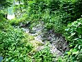
A gully running through the midden to the Damariscotta River.
-
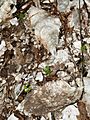
A close-up of one of the thousand-year-old oyster shells.
-
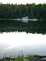
The Glidden Shell Midden is located right across the Damariscotta River.


