
White Swan, Washington facts for kids
Quick facts for kids
White Swan, Washington
|
|
|---|---|

Location of White Swan, Washington
|
|
| Country | United States |
| State | Washington |
| County | Yakima |
| Area | |
| • Total | 103.3 sq mi (267.6 km2) |
| • Land | 103.3 sq mi (267.6 km2) |
| • Water | 0.0 sq mi (0.0 km2) |
| Elevation | 968 ft (295 m) |
| Population
(2020)
|
|
| • Total | 789 |
| • Density | 7.638/sq mi (2.9484/km2) |
| Time zone | UTC-8 (Pacific (PST)) |
| • Summer (DST) | UTC-7 (PDT) |
| ZIP code |
98952
|
| Area code | 509 |
| FIPS code | 53-78365 |
| GNIS feature ID | 2409586 |
White Swan is a small community in Washington state, United States. It is located in Yakima County. In 2020, about 789 people lived there. A "census-designated place" (CDP) is a special area the government uses for counting people.
Contents
History of White Swan
White Swan is a community that is not officially a city or town. It is located on the Yakama Indian Reservation. The community was likely named after Chief White Swan of the Yakama people. This happened around the early 1900s.
The area was once part of the Mt Adams Highway. This was an old road used for travel between Yakima and The Dalles. It was used as early as the 1850s. White Swan was a stop between Union Gap and Fort Simcoe.
In 1921, a group called the Christian Church (Disciples of Christ) started the Yakima Indian Christian Mission here. Electricity came to White Swan in 1928, thanks to Pacific Power & Light Company. The White Swan Library opened in 1947. It moved to its current location in 1969. White Swan is part of the Mt Adams School District #209 and is home to White Swan High School.
Where is White Swan?
White Swan is located at 46.394444 degrees North and -120.702958 degrees West. This is a way to describe its exact spot on a map.
The United States Census Bureau says that White Swan covers about 103.3 square miles (267.6 square kilometers). All of this area is land, with no large bodies of water.
White Swan's Climate and Weather
White Swan has a climate where summers are warm but not too hot, and they are also dry. The average monthly temperatures do not go above 71.6 degrees Fahrenheit (22 degrees Celsius).
According to the Köppen climate classification system, White Swan has a "warm-summer Mediterranean climate." This type of climate is often called "Csb" on climate maps.
| Climate data for White Swan | |||||||||||||
|---|---|---|---|---|---|---|---|---|---|---|---|---|---|
| Month | Jan | Feb | Mar | Apr | May | Jun | Jul | Aug | Sep | Oct | Nov | Dec | Year |
| Record high °F (°C) | 66 (19) |
70 (21) |
80 (27) |
92 (33) |
100 (38) |
104 (40) |
111 (44) |
107 (42) |
98 (37) |
90 (32) |
74 (23) |
64 (18) |
111 (44) |
| Mean daily maximum °F (°C) | 36.9 (2.7) |
46.2 (7.9) |
56.1 (13.4) |
65.1 (18.4) |
73.9 (23.3) |
80.1 (26.7) |
88.1 (31.2) |
86.4 (30.2) |
78.3 (25.7) |
65.8 (18.8) |
49.4 (9.7) |
41.5 (5.3) |
64 (18) |
| Mean daily minimum °F (°C) | 19.8 (−6.8) |
26.3 (−3.2) |
31.5 (−0.3) |
36.5 (2.5) |
42.1 (5.6) |
48 (9) |
51.7 (10.9) |
50.1 (10.1) |
45.2 (7.3) |
36.2 (2.3) |
29 (−2) |
25.1 (−3.8) |
36.8 (2.7) |
| Record low °F (°C) | −30 (−34) |
−24 (−31) |
3 (−16) |
17 (−8) |
24 (−4) |
30 (−1) |
33 (1) |
34 (1) |
22 (−6) |
10 (−12) |
1 (−17) |
−20 (−29) |
−30 (−34) |
| Average precipitation inches (mm) | 1.5 (38) |
1 (25) |
0.64 (16) |
0.53 (13) |
0.29 (7.4) |
0.57 (14) |
0.2 (5.1) |
0.22 (5.6) |
0.24 (6.1) |
0.51 (13) |
1.11 (28) |
1.69 (43) |
8.51 (216) |
| Average snowfall inches (cm) | 11.7 (30) |
3.5 (8.9) |
1.3 (3.3) |
0 (0) |
0 (0) |
0 (0) |
0 (0) |
0 (0) |
0 (0) |
0.1 (0.25) |
2.5 (6.4) |
10.7 (27) |
29.8 (76) |
| Average precipitation days | 7 | 6 | 4 | 3 | 2 | 3 | 1 | 2 | 2 | 3 | 6 | 8 | 47 |
Population of White Swan
| Historical population | |||
|---|---|---|---|
| Census | Pop. | %± | |
| 1990 | 2,669 | — | |
| 2000 | 3,033 | 13.6% | |
| 2010 | 793 | −73.9% | |
| 2020 | 789 | −0.5% | |
| U.S. Decennial Census | |||
In 2000, there were 3,033 people living in White Swan. These people lived in 775 households, and 658 of these were families. The population density was about 29.4 people per square mile. There were 831 housing units in total.
The people living in White Swan came from different backgrounds:
- 26.24% were White
- 59.28% were Native American
- 8.14% were from other races
- 5.74% were from two or more races
- About 15.99% of the population were Hispanic or Latino.
Many households had children under 18 living with them (49.4%). Most households (55.2%) were married couples living together. The average household had about 3.91 people.
The population was quite young. About 40.0% of the people were under 18 years old. The average age was 25 years.
The median income for a household was $35,189. The median income for a family was $35,333. About 27.0% of the population lived below the poverty line. This included 30.4% of those under 18.
Famous People from White Swan
Some notable people have connections to White Swan:
- Nipo T. Strongheart: He was born in White Swan.
- Mickey and Karen Taylor: They owned the famous racehorse Seattle Slew.
- Black Lodge Singers: This is a well-known Native American drum group.
Images for kids
-
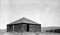
The Blockhouse at Fort Simcoe, built around 1858.

See also
 In Spanish: White Swan (Washington) para niños
