Whiteside (Lake District) facts for kids
Quick facts for kids Whiteside |
|
|---|---|

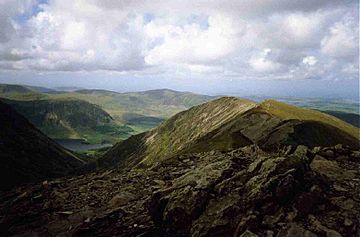
Looking along the ridge from Hopegill Head to Whiteside. The east top is visible midway along
|
|
| Highest point | |
| Elevation | 719 m (2,359 ft) |
| Prominence | c. 34 m |
| Parent peak | Hopegill Head |
| Listing | Wainwright, Hewitt, Nuttall |
| Geography | |
| Location | Cumbria, England |
| Parent range | Lake District, North Western Fells |
| OS grid | NY175221 |
| Topo map | OS Landranger 89, 90, Explorer OL4 |
| Listed summits of Whiteside (Lake District) | ||||
| Name | Grid ref | Height | Status | |
|---|---|---|---|---|
| Whiteside ("Wainwright" top) | NY170219 | 707 m (2,320 ft) | Nuttall | |
Whiteside is a mountain, or 'fell,' located in the beautiful Lake District in England. It's found at the western end of a ridge that includes Grisedale Pike and Hopegill Head, and it looks out over Crummock Water.
Contents
What is Whiteside?
The Lake District has different groups of fells. Whiteside is part of the 'North Western Fells,' which are hills found between the Derwent and Cocker rivers. This area is divided into three parts by two roads. Whiteside is in the middle section, between Whinlatter Pass and Newlands Pass.
The highest points in this group of fells form a shape like the letter 'H' lying on its side. Whiteside, Hopegill Head, and Grisedale Pike make up the northern part of this 'H'. The Grasmoor to Causey Pike ridge runs next to it on the south. The connection between these two ridges is a pass called Coledale Hause. This pass is at the top of two valleys: Coledale, which goes east, and Gasgale Gill, which flows west.
Whiteside itself is shaped like a gentle curve, bending inwards on its southern side. This side has a huge rock face called Gasgale Crags. These crags drop about 150 meters straight down from the top of the mountain into the valley below. The eastern end of Whiteside connects to Hopegill Head without much change in height. The western end of the ridge drops steeply down over an area called Whiteside End, leading to the Vale of Lorton. A smaller peak called Whin Ben (413 meters) is at the southwest corner. It looks over the spot where Gasgale Gill flows into the fields of Lanthwaite.
The northern slopes of Whiteside are much wider and have two long ridges coming off the main mountain. The shorter one is called Penn, and further east is Dodd (454 meters). The valley of Hopegill separates Dodd from Ladyside Pike and the northern ridge of Hopegill Head.
What is Whiteside Made Of?
The rocks on the southern cliffs of Whiteside are from the Kirkstile Formation. These are mostly layers of mudstone and siltstone. To the north, you'll find rocks from the Loweswater Formation, which are made of a type of sandstone called greywacke. Near Dodd, there are rocks from the Hopebeck Formation, which include mudstone, siltstone, and greywacke sandstone that formed from underwater landslides. There's also a small amount of a special rock called lamprophyre in this area.
People have tried to mine on the western slopes of Whiteside in two places. On the northern side of Gasgale Gill, there's a short tunnel, possibly dug to find the Force Crag vein from Coledale (which was a famous mine). Below Whiteside End, there's a small old mine where some galena (a lead ore) was dug out.
How Many Tops Does Whiteside Have?
Whiteside actually has three main tops!
- The "Wainwright" top is at the end of the ridge closest to Crummock Water. It is 707 meters (2,320 feet) high. Alfred Wainwright, who wrote famous guidebooks about the Lake District fells, chose this as the main summit in his book, even though it's not the very highest point. This western top is tall enough to be called a Nuttall (another list of mountains).
- The true highest point is called the Whiteside East top. This top is about 400 meters further along the ridge towards Hopegill Head. It's significantly higher at 719 meters (2,359 feet). The Nuttalls also call this the "Whiteside East Top," and the lower "Wainwright" summit simply "Whiteside."
- The third top is even further east, past the true summit. It is 703 meters (2,306 feet) high and is sometimes called Gasgill Crags in some guidebooks.
From the top of Whiteside, you can see amazing views of West Cumbria, the Solway Firth, and even the hills of Scotland. Closer by, the views of other fells are partly blocked by Grasmoor and Crag Hill to the south, and Hopegill Head to the east. However, you can still see groups of fells in the gaps. If you walk a little down to the west, you can get a better view of Crummock Water and Loweswater. The walk along the ridge between Whiteside and Hopegill Head is considered one of the best in the area. Alfred Wainwright described it as “an exhilarating high level traverse” (an exciting high-level journey). There are also fantastic views looking down into Gasgale Gill on the southern side.
How Can You Climb Whiteside?
The most common way to climb Whiteside is from Lanthwaite Green, which is at the north end of Crummock Water. This route goes up grassy slopes over the smaller top of Whin Ben before reaching the main summit. You can also climb Whiteside from the north, using either the Dodd or Penn ridges.
See also
 In Spanish: Whiteside (Distrito de los Lagos) para niños


