Whittier Narrows facts for kids
Quick facts for kids Whittier Narrows |
|
|---|---|

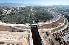
Aerial view of Whittier Narrows Dam from downstream looking upstream through the gap.
|
|
| Elevation | 183 ft (56 m) |
| Traversed by | |
| Location | North of Whittier, California |
| Range | Puente Hills / Montebello Hills |
| Coordinates | 34°01′45″N 118°02′58″W / 34.02917°N 118.04944°W |
The Whittier Narrows is a special place in California, United States. It's like a natural opening or "gap" between two sets of hills: the Puente Hills on the east and the Montebello Hills on the west. This gap is found at the southern edge of the San Gabriel Valley. Two important rivers, the Rio Hondo and the San Gabriel River, flow through this narrow passage. They then continue into the wider Los Angeles Basin. Major roads like Interstate 605 and California State Route 19 also pass through the Whittier Narrows.
Contents
The History of Whittier Narrows
Early Explorers and Missions
The first European explorers to reach Alta California were part of the Spanish Portolá expedition. They discovered Whittier Narrows on their way back to San Diego. On their journey out, they had followed San Jose Creek. This led them to the San Gabriel River, just north of the Narrows.
A Franciscan missionary named Juan Crespi wrote in his diary about the area. He described starting through the "gap of the valley of San Miguel," which is now the San Gabriel Valley. He noted it was "very full of trees." He also wrote about traveling along a stream that became a river. Its banks were covered with willows and cottonwood trees.
Because of this exploration, a mission called Mission Vieja was built at Whittier Narrows in 1771. However, a big flood in 1776 caused the mission to move. It was rebuilt as Mission San Gabriel Arcángel in the city of San Gabriel.
Land Boundaries and an Earthquake
Whittier Narrows was an important meeting point for land boundaries. These boundaries were for large land grants called ranchos. These ranchos were created during the time when Spain and Mexico controlled California. One of these was the Rancho Paso de Bartolo.
On October 1, 1987, at 7:42 a.m., a 5.9 magnitude earthquake struck. This event is known as the 1987 Whittier Narrows earthquake. It strongly affected the Greater Los Angeles Area. People felt the shaking very severely.
Whittier Narrows Recreation Area
The Whittier Narrows Recreation Area is a huge park. It has many different things to do. Most of the park is in an area of Los Angeles County that isn't part of a city.
Fun Activities at the Park
The park has several lakes, including North Lake, Center Lake, and Legg Lake. At Legg Lake, you can even operate radio-controlled model speedboats! There's also a shooting range for rifles and pistols. You'll find many fields for softball and soccer, along with picnic tables. For hobbyists, there's a paved airstrip for radio-controlled model aircraft.
The park also connects to bike paths. You can ride your bike from the Rio Hondo bicycle path to the San Gabriel River bicycle path. The park is generally bordered by Garvey Avenue and San Gabriel Boulevard to the north and west. Durfee Avenue and Santa Anita/Merced Avenues are to the south and east. A good way to get there is by taking the Rosemead Boulevard (State Route 19) exit south from the Pomona (60) Freeway.
The Nature Center
Inside the Recreation Area, you'll find the Whittier Narrows Nature Center. This center has exhibits about the plants and animals that live in the river environment. Some exhibits even have live animals! The center offers public programs, talks, and guided tours by park rangers. They also have educational programs for students. In 2008, there was some discussion about building a new center. Some people worried it might harm the existing wildlife habitat.
Whittier Narrows Dam
The Whittier Narrows Dam is an important structure. It helps control floods and saves water. The U.S. Army Corps of Engineers, Los Angeles District, built and operates it.
How the Dam Works
The dam collects rainwater runoff from areas upstream that aren't controlled. It also takes in water released from the Santa Fe Dam. The Whittier Narrows Dam can then send this water into either the Rio Hondo or the San Gabriel River downstream. This helps prevent flooding in communities below the dam. The dam was finished in 1957.
 | Sharif Bey |
 | Hale Woodruff |
 | Richmond Barthé |
 | Purvis Young |


