Wilkie Sugar Loaf facts for kids
Quick facts for kids Wilkie Sugar Loaf |
|
|---|---|
 |
|
| Highest point | |
| Elevation | 411.8 m (1,351 ft) |
| Prominence | 220 m (720 ft) |
| Naming | |
| Etymology | family name of pioneer settlers + pyramidal shape of mountain |
| Native name | [Squa-dichk] Error: {{native name}}: unrecognized language tag: Mi'kmaq language (help) (language?) |
| Geography | |
| Parent range | Cape Breton Highlands |
| Topo map | NTS O11/K16 |
| Climbing | |
| Easiest route | Hike |
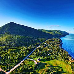
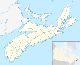
Wilkie Sugar Loaf is a special mountain peak in Nova Scotia, Canada. It's found in the beautiful Cape Breton Highlands, close to a small community also called Sugar Loaf. This mountain is a popular spot for hikers and offers amazing views.
About Wilkie Sugar Loaf Mountain
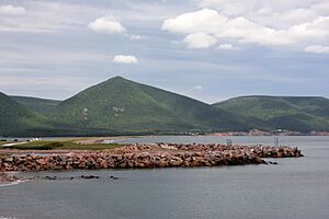
Wilkie Sugar Loaf is a mountain covered in trees. It rises right from the edge of Aspy Bay. This mountain is about 10 kilometers (6 miles) north of the famous Cabot Trail.
It's one of the few mountains in Nova Scotia that stands alone. It climbs more than 400 meters (1,300 feet) above the sea. It does this in less than 1.5 kilometers (0.9 miles)! This peak is part of the North Mountain range. Deep valleys, made by Wilkie and Pollys brooks, separate it from the rest of the hills.
How Wilkie Sugar Loaf Got Its Name
The name "Wilkie Sugar Loaf" became official on April 21, 1936. The name has two parts:
- Wilkie: This comes from the Wilkie family. They were early settlers in the area around 1820. James Wilkie Jr. was one of the first people to receive land here in 1852.
- Sugar Loaf: This part describes the mountain's shape. It looks like a "sugarloaf", which was a cone-shaped block of sugar.
People were already using the name Wilkie Sugar Loaf in maps and sailing guides by 1860. The Mi'kmaq people, who are the original inhabitants of this land, had their own name for the mountain. They called it "Squa-dichk," which means "the highest point."
Hiking the Wilkie Sugar Loaf Trail
You can reach the top of Wilkie Sugar Loaf by hiking a trail. The Wilkie Sugar Loaf trail starts on the west side of the Bay St Lawrence Road. This is about 1.15 kilometers (0.71 miles) north of the entrance to Cabots Landing Provincial Park.
The trail leads you to the mountain's peak. From the top, you can enjoy views from two special look-off points.
- One look-off faces south-west. You can see the Aspy Fault plateau and the national park in the distance. You can also see the beach at Cabots Landing, Aspy Harbour, and the villages of Cape North and Dingwall.
- The second look-off shows you the hills to the north. You can also see Bay St. Lawrence and the large Gulf of St. Lawrence beyond. On a very clear day, you might even see all the way to Newfoundland!
 | Aaron Henry |
 | T. R. M. Howard |
 | Jesse Jackson |


