Wilmington, South Australia facts for kids
Quick facts for kids WilmingtonSouth Australia |
|||||||||||||||
|---|---|---|---|---|---|---|---|---|---|---|---|---|---|---|---|

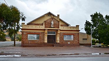
Wilmington Memorial Hall, 2017
|
|||||||||||||||
| Established | 13 April 1876 (town) 13 March 1997 (locality) |
||||||||||||||
| Postcode(s) | 5485 | ||||||||||||||
| Time zone | ACST (UTC+9:30) | ||||||||||||||
| • Summer (DST) | ACST (UTC+10:30) | ||||||||||||||
| Location |
|
||||||||||||||
| LGA(s) |
|
||||||||||||||
| Region | Yorke and Mid North | ||||||||||||||
| County | Frome | ||||||||||||||
| State electorate(s) | Stuart | ||||||||||||||
| Federal Division(s) | Grey | ||||||||||||||
|
|||||||||||||||
|
|||||||||||||||
| Footnotes | Adjoining localities | ||||||||||||||
Wilmington is a town in the Yorke and Mid North region of South Australia. It is about 305 kilometers (190 miles) north of Adelaide, the state capital. The town is part of the District Council of Mount Remarkable area.
Wilmington was first called "Beautiful Valley." It is a farming community known for raising sheep and growing crops like wheat and barley. Recently, the weather has also made it a good place to grow olive trees.
The town has many useful places for residents and visitors. You can find a post office, a hotel, and two caravan parks. There is also a take-away shop, two service stations, a primary school, and a kindergarten. For fun, there is a museum and an op shop (thrift store).
Wilmington is close to the Mount Remarkable National Park. The beautiful Alligator Gorge is only a 10-minute drive away. Many people stay in Wilmington because it is near popular tourist spots in the Flinders Ranges, like Wilpena Pound.
Contents
History of Wilmington
Wilmington was an important stop for transporting goods long ago. Farmers used horses and carts to move grain and wool from Port Augusta to Adelaide. The historic Wilmington Coaching Stables on Fourth Street are still there today. They are listed on the South Australian Heritage Register because they are so important to the town's past.
Local Government Changes
Wilmington and the areas around it used to have their own local government. This was called the District Council of Wilmington. In 1980, it joined with the current District Council of Mount Remarkable.
How to Get Around Wilmington
Wilmington was once the end point of the Wilmington railway line. This train line was built in 1915 and operated until it closed in 1990.
Today, Wilmington is located on the Horrocks Highway. This highway is a major road that connects many towns. In Wilmington, the Main North Road turns west towards Horrocks Pass. The Horrocks Highway then continues north towards Quorn, South Australia. South of Wilmington, the same road has both names until it reaches Gawler, which is near Adelaide.
What Happened to Terka?
In 1924, a town called Terka was planned near a railway stop. This stop was about six kilometers south of Wilmington. The name "Terka" came from a nearby farm. However, the town of Terka was officially closed in 1983. Now, the area where Terka once was is considered part of Wilmington.
 | Chris Smalls |
 | Fred Hampton |
 | Ralph Abernathy |


