Wolverine Peak (Alaska) facts for kids
Quick facts for kids Wolverine Peak |
|
|---|---|

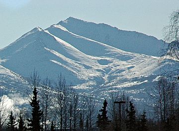
Northwest aspect, from Anchorage
|
|
| Highest point | |
| Elevation | 4,491 ft (1,369 m) |
| Prominence | 685 ft (209 m) |
| Isolation | 1.85 mi (2.98 km) |
| Parent peak | Mount Elliott |
| Geography | |
| Location | Chugach State Park Anchorage Municipality, Alaska United States |
| Parent range | Chugach Mountains |
| Topo map | USGS Anchorage A-7 |
| Climbing | |
| Easiest route | Hiking trail class 2 |
Wolverine Peak is a mountain in Alaska, United States. It stands tall at about 4,491 feet (1,369 meters) high. This peak is part of the western Chugach Mountains. It is located near Anchorage Municipality.
The mountain is inside Chugach State Park. It is about 10 miles (16 km) southeast of downtown Anchorage. Wolverine Peak is a very noticeable mountain in the Anchorage skyline.
How Wolverine Peak Got Its Name
The mountain got its name in 1963. Members of the Mountaineering Club of Alaska were exploring the area. They found tracks of a wolverine animal in the snow near the top. Because of this, they decided to name the peak after the wolverine. The name became official in 1964. The United States Board on Geographic Names approved it.
Hiking to the Summit
Wolverine Peak is a popular spot for hikers. There is a five-mile (8 km) trail that leads to the very top. The hike is known for its amazing views. From the summit, you can see many famous landmarks.
- You can see Mount Williwaw, another nearby mountain.
- On clear days, you might even spot Denali and Mount Foraker. These are two of North America's tallest peaks.
- You can also enjoy views of Cook Inlet and the city of Anchorage.
Climate Around Wolverine Peak
The area around Wolverine Peak has a subarctic climate. This means it has long, cold, and snowy winters. The summers are usually mild. Temperatures can drop very low in winter. They can go below -20 °C (-4 °F). With wind, it can feel even colder, below -30 °C (-22 °F).
Rain and melting snow from the peak flow into Campbell Creek. This creek then empties into Turnagain Arm.
 | Aaron Henry |
 | T. R. M. Howard |
 | Jesse Jackson |


