Woodbine, Georgia facts for kids
Quick facts for kids
Woodbine, Georgia
|
|||
|---|---|---|---|

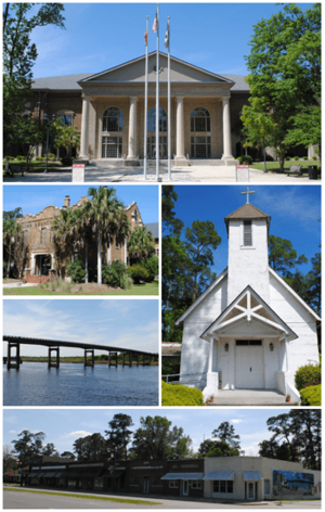
Top, left to right: Camden County Courthouse, Old Camden County Courthouse, Satilla River, St. Mark's Episcopal Church, Woodbine Historic District
|
|||
|
|||
| Motto(s):
"Cherish Yesterday, Embrace Today, Prepare for Tomorrow"
|
|||

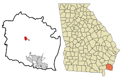
Location in Camden County and the state of Georgia
|
|||
| Country | United States | ||
| State | Georgia | ||
| County | Camden | ||
| Area | |||
| • Total | 2.61 sq mi (6.76 km2) | ||
| • Land | 2.54 sq mi (6.59 km2) | ||
| • Water | 0.07 sq mi (0.17 km2) | ||
| Elevation | 13 ft (4 m) | ||
| Population
(2020)
|
|||
| • Total | 1,062 | ||
| • Density | 417.45/sq mi (161.20/km2) | ||
| Time zone | UTC-5 (Eastern (EST)) | ||
| • Summer (DST) | UTC-4 (EDT) | ||
| ZIP code |
31569
|
||
| Area code(s) | 912 | ||
| FIPS code | 13-83868 | ||
| GNIS feature ID | 0325526 | ||
Woodbine is a small city located in Camden County, Georgia, in the United States. It is the main city, also known as the county seat, for Camden County. This county was first created when Georgia became a state in 1777.
In 2020, about 1,062 people lived in Woodbine. This number was a bit lower than in 2010, when 1,412 people lived there. Woodbine is also part of the larger Kingsland, Georgia area.
A long walking and biking path called the East Coast Greenway passes through Woodbine. This trail stretches for 3,000 miles, connecting states from Maine all the way to Florida. In Woodbine, it runs along the Woodbine Riverwalk. Close to the city, there are plans to build Spaceport Camden, which could be a place for launching rockets.
Contents
History of Woodbine
Early Land Grants
Records from 1765 show that some people, including John Brown, asked the English government for land south of the Satilla River. They were given about 1,400 acres of land called Pile's Bluff. Historians believe this area was close to where Woodbine is today.
In 1808, a piece of land was given to Anton Cunning by the state. This land later became known as the Woodbine Plantation.
Plantation Life and the Civil War
Luke John Bailey bought the Woodbine Plantation in 1835. He owned it through the Civil War. During the war, the main house on the plantation was burned down by Union troops.
After the war, James King Bedell bought the property. He built a new house and brought the plantation back to life.
The Railroad and Town Growth
When the railroad came to Camden County in 1893, James King Bedell sold a part of his land for the tracks. However, he had one important rule: the very first community built along the railroad had to be named "Woodbine."
Woodbine officially became a town on August 13, 1908. The name "Woodbine" comes from a common English name for the honeysuckle flower, Lonicera. The town grew even more after the Atlantic Coastal Highway was built in 1927. The next year, in 1928, the county seat was moved to Woodbine, making it an even more important place. Woodbine became a city in 1953.
The Thiokol Explosion
On February 3, 1971, a factory in Woodbine called Thiokol Chemical Corporation had a terrible explosion. This factory made flares for soldiers. A fire in a small building led to a very large explosion. This sad event caused many workers to be injured, and 28 people lost their lives. Pieces of the building were blown almost a mile away. It was a very difficult day for the community of Woodbine.
Geography and Climate
Where is Woodbine?
Woodbine is located in the middle of Camden County. This county is in the southeast corner of Georgia, very close to the Florida border. The city sits on the south side of the Satilla River.
U.S. Route 17, also known as Ocean Highway, goes right through the center of Woodbine. This highway can take you about 29 miles northeast to Brunswick or about 11 miles south to Kingsland. The city has also grown eastward along 10th Street to reach Interstate 95 at Exit 14.
Woodbine's exact location is at 30 degrees 57 minutes 43 seconds North and 81 degrees 43 minutes 12 seconds West.
Land and Water
The United States Census Bureau says that Woodbine covers a total area of about 2.61 square miles (6.7 square kilometers). Most of this area, about 2.54 square miles (6.5 square kilometers), is land. The rest, about 0.07 square miles (0.2 square kilometers), is water.
Weather in Woodbine
Woodbine has a warm climate. Here are some average temperatures and rainfall amounts:
| Climate data for Woodbine, Georgia (1991–2020 normals, extremes 1998–present) | |||||||||||||
|---|---|---|---|---|---|---|---|---|---|---|---|---|---|
| Month | Jan | Feb | Mar | Apr | May | Jun | Jul | Aug | Sep | Oct | Nov | Dec | Year |
| Record high °F (°C) | 84 (29) |
86 (30) |
91 (33) |
94 (34) |
98 (37) |
100 (38) |
102 (39) |
102 (39) |
96 (36) |
94 (34) |
89 (32) |
85 (29) |
102 (39) |
| Mean daily maximum °F (°C) | 62.6 (17.0) |
65.9 (18.8) |
71.9 (22.2) |
77.7 (25.4) |
83.7 (28.7) |
88.2 (31.2) |
90.9 (32.7) |
89.2 (31.8) |
85.3 (29.6) |
78.6 (25.9) |
70.4 (21.3) |
64.5 (18.1) |
77.4 (25.2) |
| Daily mean °F (°C) | 50.3 (10.2) |
53.7 (12.1) |
59.3 (15.2) |
65.2 (18.4) |
72.3 (22.4) |
78.2 (25.7) |
80.9 (27.2) |
80.2 (26.8) |
76.4 (24.7) |
68.0 (20.0) |
59.0 (15.0) |
53.0 (11.7) |
66.4 (19.1) |
| Mean daily minimum °F (°C) | 38.0 (3.3) |
41.5 (5.3) |
46.7 (8.2) |
52.7 (11.5) |
61.0 (16.1) |
68.2 (20.1) |
70.9 (21.6) |
71.1 (21.7) |
67.4 (19.7) |
57.3 (14.1) |
47.6 (8.7) |
41.5 (5.3) |
55.3 (12.9) |
| Record low °F (°C) | 10 (−12) |
10 (−12) |
21 (−6) |
22 (−6) |
41 (5) |
51 (11) |
58 (14) |
57 (14) |
50 (10) |
30 (−1) |
24 (−4) |
19 (−7) |
10 (−12) |
| Average precipitation inches (mm) | 3.61 (92) |
3.67 (93) |
3.58 (91) |
3.52 (89) |
3.92 (100) |
6.20 (157) |
5.51 (140) |
7.76 (197) |
6.70 (170) |
4.74 (120) |
2.33 (59) |
3.04 (77) |
54.58 (1,386) |
| Average precipitation days (≥ 0.01 in) | 7.3 | 7.9 | 6.9 | 6.0 | 6.0 | 11.5 | 11.9 | 14.1 | 11.0 | 6.8 | 5.3 | 6.9 | 101.6 |
| Source: NOAA | |||||||||||||
Population and People
How Many People Live Here?
The population of Woodbine has changed over the years. Here's how many people have lived in the city during different census counts:
| Historical population | |||
|---|---|---|---|
| Census | Pop. | %± | |
| 1910 | 155 | — | |
| 1920 | 172 | 11.0% | |
| 1930 | 335 | 94.8% | |
| 1940 | 373 | 11.3% | |
| 1950 | 750 | 101.1% | |
| 1960 | 845 | 12.7% | |
| 1970 | 1,002 | 18.6% | |
| 1980 | 910 | −9.2% | |
| 1990 | 1,212 | 33.2% | |
| 2000 | 1,218 | 0.5% | |
| 2010 | 1,412 | 15.9% | |
| 2020 | 1,062 | −24.8% | |
| U.S. Decennial Census 1850-1870 1870-1880 1890-1910 1920-1930 1940 1950 1960 1970 1980 1990 2000 2010 |
|||
Who Lives in Woodbine?
Based on the 2020 United States census, there were 1,062 people living in Woodbine. These people made up 467 households, and 316 of these were families.
Here's a look at the different groups of people living in Woodbine in 2020:
| Race | Num. | Perc. |
|---|---|---|
| White (not Hispanic) | 606 | 57.06% |
| Black or African American (not Hispanic) | 385 | 36.25% |
| Native American | 4 | 0.38% |
| Asian | 7 | 0.66% |
| Pacific Islander | 4 | 0.38% |
| Other/Mixed | 44 | 4.14% |
| Hispanic or Latino | 12 | 1.13% |
See also
 In Spanish: Woodbine (Georgia) para niños
 | Janet Taylor Pickett |
 | Synthia Saint James |
 | Howardena Pindell |
 | Faith Ringgold |


