
Woodbury, Georgia facts for kids
Quick facts for kids
Woodbury, Georgia
|
|
|---|---|

"A Peach of a Place"
|
|

Location in Meriwether County and the state of Georgia
|
|
| Country | United States |
| State | Georgia |
| County | Meriwether |
| Area | |
| • Total | 2.10 sq mi (5.44 km2) |
| • Land | 2.07 sq mi (5.36 km2) |
| • Water | 0.03 sq mi (0.08 km2) |
| Elevation | 827 ft (252 m) |
| Population
(2020)
|
|
| • Total | 908 |
| • Density | 438.86/sq mi (169.47/km2) |
| Time zone | UTC-5 (Eastern (EST)) |
| • Summer (DST) | UTC-4 (EDT) |
| ZIP code |
30293
|
| Area code(s) | 706 |
| FIPS code | 13-83896 |
| GNIS feature ID | 0333457 |
Woodbury is a city located in Meriwether County, Georgia, in the United States. In 2020, about 908 people lived there. It's known as "A Peach of a Place."
Contents
History of Woodbury
Woodbury became an official city in 1913. This happened when the Georgia General Assembly (which is like Georgia's state government) approved it. The city was probably named after Levi Woodbury. He was an important American judge who served on the United States Supreme Court many years ago.
Geography of Woodbury
Woodbury is located in the southeastern part of Meriwether County. You can find it at coordinates 32.980588 degrees North and 84.580979 degrees West.
Major Roads in Woodbury
Several main roads, called Georgia State Routes, go through Woodbury:
- Route 18 goes northwest about 8 miles to Greenville, which is the county seat. It also goes northeast about 19 miles to Zebulon.
- Route 74 leaves Woodbury heading east with Route 18. It then goes southeast about 19 miles to Thomaston. To the north, Route 74 leads about 8 miles to Gay.
- Route 85 goes north to Gay with Route 74. It also leads south about 10 miles to Manchester.
- Route 85 Alternate runs through the northern part of Woodbury. It goes southwest about 9 miles to Warm Springs.
- Route 109 follows Route 18 both northwest and east from Woodbury. It leads east about 28 miles to Barnesville.
Natural Features Near Woodbury
The United States Census Bureau says Woodbury covers about 2.1 square miles of land. Only a small part, about 0.03 square miles, is water. The Flint River flows about 3 miles east of the city. Also, Pine Mountain is a mountain range that rises about 3 miles south of Woodbury.
Population Changes in Woodbury
The number of people living in Woodbury has changed over the years. Here's how the population has grown and shrunk:
| Historical population | |||
|---|---|---|---|
| Census | Pop. | %± | |
| 1880 | 94 | — | |
| 1890 | 369 | 292.6% | |
| 1900 | 566 | 53.4% | |
| 1910 | 917 | 62.0% | |
| 1920 | 923 | 0.7% | |
| 1930 | 849 | −8.0% | |
| 1940 | 865 | 1.9% | |
| 1950 | 985 | 13.9% | |
| 1960 | 1,230 | 24.9% | |
| 1970 | 1,422 | 15.6% | |
| 1980 | 1,738 | 22.2% | |
| 1990 | 1,429 | −17.8% | |
| 2000 | 1,184 | −17.1% | |
| 2010 | 961 | −18.8% | |
| 2020 | 908 | −5.5% | |
| U.S. Decennial Census 1850-1870 1870-1880 1890-1910 1920-1930 1940 1950 1960 1970 1980 1990 2000 2010 |
|||
According to the 2020 United States census, there were 908 people living in Woodbury. These people lived in 456 households, and 260 of those were families.
Images for kids
-
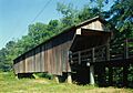
The Red Oak Creek Covered Bridge is located just north of Woodbury. Built in the 1840s by the famous Georgia bridge builder, Horace King, this bridge is the longest covered bridge in Georgia and is still used today. It was added to the National Register of Historic Places in 1973.
_Red_Oak_Creek,_Huel_Brown_Road_(Cov,_Woodbury_vicinity_(Meriwether_County,_Georgia)).jpg)
See also
 In Spanish: Woodbury (Georgia) para niños
