Y Garn (Nantlle Ridge) facts for kids
Quick facts for kids Y Garn |
|
|---|---|

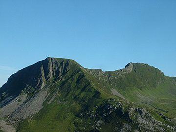
Y Garn (left) and Mynydd Drws-y-Coed (right) from Mynydd Mawr
|
|
| Highest point | |
| Elevation | 633 m (2,077 ft) |
| Prominence | 21 m (69 ft) |
| Listing | sub Hewitt, Nuttall |
| Naming | |
| Language of name | Welsh |
| Geography | |
| Location | Gwynedd, Wales |
| Parent range | Moel Hebog |
| Topo map | OS Landranger 115, OS Outdoor Leisure 17 |
| Climbing | |
| Easiest route | Walk |
Y Garn is a smaller peak, or "top," located in the beautiful Snowdonia National Park in north Wales. It's connected to a larger mountain called Mynydd Drws-y-Coed. Y Garn marks the eastern end of a famous line of hills known as the Nantlle Ridge.
Contents
Exploring Y Garn
Y Garn is a part of the stunning Moel Hebog mountain range. It stands 633 meters (about 2,077 feet) tall. This makes it a great spot for hikers and nature lovers.
What Makes Y Garn Special?
Y Garn has some interesting features that make it unique.
Steep Cliffs
On its north side, Y Garn has very steep cliffs. These rocky walls drop sharply, making them look dramatic. They are a challenge for climbers but offer amazing views.
The Summit Plateau
The very top of Y Garn is not a sharp point. Instead, it's a wide, flat, rocky area called a plateau. This plateau is the highest part of the mountain. It's a perfect place to stop and enjoy the scenery.
Shelter Cairns
On the summit plateau, you'll find two large piles of stones. These are called "cairns." Hikers often build cairns as markers or to provide shelter from the wind. These cairns on Y Garn are big enough to offer a good place to rest.
Hiking Y Garn
Hiking to the top of Y Garn is a popular activity. The easiest way to reach the summit is by walking. It's a rewarding climb that offers incredible views of the surrounding Welsh landscape. You can see other mountains, valleys, and even the sea on a clear day.
 | Misty Copeland |
 | Raven Wilkinson |
 | Debra Austin |
 | Aesha Ash |

