Yarlung Tsangpo Grand Canyon facts for kids


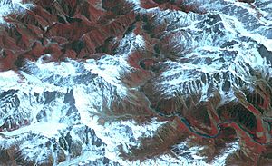
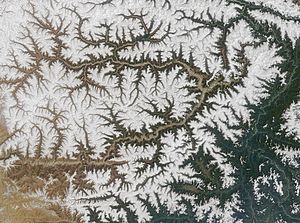
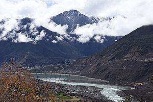
The Yarlung Tsangpo Grand Canyon is a huge, deep valley carved by the Yarlung Tsangpo River in Tibet, China. It's also known by other names like the Tsangpo Canyon or the Brahmaputra Canyon. This amazing canyon is the deepest in the world! It stretches for about 505 kilometers (314 miles), which makes it a bit longer than the famous Grand Canyon in the United States.
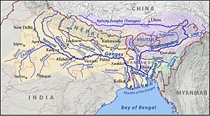
The Yarlung Tsangpo River is the upper part of the Brahmaputra River. It starts near Mount Kailash and flows east for about 1,700 kilometers (1,056 miles). Then, it enters this incredible gorge near a place called Zhibe. The canyon itself is about 240 kilometers (149 miles) long. It curves around a giant mountain called Namcha Barwa, which is 7,782 meters (25,531 feet) tall. As the river flows through the canyon, it drops from about 2,900 meters (9,514 feet) to 1,500 meters (4,921 feet). After the canyon, the river continues towards the Indian border and eventually becomes the Brahmaputra River.
Contents
How Deep is the Canyon?
The Yarlung Tsangpo Grand Canyon is incredibly deep. As the river flows between the towering peaks of Namcha Barwa and Gyala Peri mountains, the canyon reaches an average depth of about 5,000 meters (16,000 feet) around Namcha Barwa.
Overall, the canyon's average depth is about 2,268 meters (7,440 feet). But in some parts, it plunges even deeper, reaching an astonishing 6,009 meters (19,714 feet)! This makes it the deepest canyon found on land anywhere in the world.
Life in the Canyon
The Yarlung Tsangpo Grand Canyon is home to a very special ecosystem. This means it has unique plants and animals that haven't been explored much by people. The climate here changes a lot, from warm, subtropical areas to very cold, Arctic-like conditions.
The highest temperature ever recorded in Tibet was 43.6 degrees Celsius (110.5 degrees Fahrenheit) near the Indian border. One of the rare animals found here is the takin, a type of goat-antelope. Local tribes sometimes hunt these animals.
The "Everest of Rivers"

People in the West became interested in the Tsangpo River in the 1800s. British explorers wondered where this river, flowing east from Tibet, ended up. They thought it might be the same as the Brahmaputra River. Since British citizens couldn't enter Tibet, they hired Indian explorers, called "pundits," to find out.
One pundit named Kinthup tried to explore the gorge but found it too difficult to pass through. Later, in 1913, explorers Frederick Marshman Bailey and Henry Morshead led an expedition. They finally confirmed that the Tsangpo River was indeed the upper part of the Brahmaputra.
In 1924, Frank Kingdon-Ward went on an expedition hoping to find a huge waterfall. He thought a big waterfall would explain the difference in height between the Tsangpo and Brahmaputra rivers. He found that the gorge had many steep sections and a waterfall he called "Rainbow Falls," but it wasn't as big as he expected.
After a border dispute between China and India, the area was closed for a while. But in the 1990s, the Chinese government started allowing visitors again. Since then, the gorge has become famous among kayakers. It's often called the "Everest of Rivers" because of how challenging and dangerous the conditions are.
The first attempt to kayak the gorge was in 1993 by a Japanese team, but they lost a member. In 1998, a National Geographic Society expedition also faced high water levels and lost a kayaker named Doug Gordon. However, in 2002, an international team successfully completed the first full trip down the upper part of the Tsangpo gorge.
The biggest waterfalls in the gorge, known as Tsangpo Badong waterfalls, were visited in 1998. A team estimated one of the falls to be about 33 meters (108 feet) high. These falls and the surrounding area are considered sacred by Tibetan Buddhists. There are two main waterfalls in this section: Rainbow Falls (about 21 meters or 70 feet high) and Hidden Falls (about 30 meters or 100 feet high).
Future Plans for the River
The government of China has created a "Yarlung Tsangpo Grand Canyon National Reservation" to protect this special area. However, there have also been plans to build a very large dam here. This dam would be used to create hydroelectric power and move water to other parts of China.
Such a dam would be even bigger than the Three Gorges Dam. It could generate a massive 50,000 megawatts of electricity, which is more than double what the Three Gorges Dam produces. People are worried that building such a huge dam could force local people to move from their homes. It could also harm the unique plants and animals in the ecosystem. Countries downstream, like India and Bangladesh, are also concerned about how this project might affect their water supply and environment.
- The amazing gorges of this area might have inspired the idea of Shangri-La. This is a fictional paradise described in James Hilton's 1933 book Lost Horizon.
- In the 2007 fighting game Akatsuki Blitzkampf, a secret base for a villain group is hidden in the Yarlung Tsangpo Grand Canyon. It's called the "Tsangpo Ravine" in the game.
See also
 In Spanish: Gran Cañón Yarlung Tsangpo para niños
 | Toni Morrison |
 | Barack Obama |
 | Martin Luther King Jr. |
 | Ralph Bunche |


