Yellowtail Dam facts for kids
Quick facts for kids Yellowtail Dam |
|
|---|---|

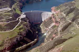
View of the dam face looking upstream
|
|
|
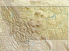
Location of the Yellowtail Dam in Montana
|
|
| Country | United States |
| Location | Big Horn County, Montana |
| Coordinates | 45°18′24″N 107°57′29″W / 45.30667°N 107.95806°W |
| Construction began | 1961 |
| Opening date | 1967 |
| Construction cost | $110 million |
| Owner(s) | U.S. Bureau of Reclamation |
| Dam and spillways | |
| Type of dam | Concrete arch-gravity |
| Impounds | Bighorn River |
| Height | 525 ft (160 m) |
| Length | 1,480 ft (450 m) |
| Width (crest) | 22 ft (6.7 m) |
| Width (base) | 147 ft (45 m) |
| Dam volume | 1,545,664 cu yd (1,181,745 m3) |
| Spillways | 1 main + outlet works |
| Spillway type | Concrete tunnel, 2x radial gates |
| Spillway capacity | 92,000 cu ft/s (2,600 m3/s) |
| Reservoir | |
| Creates | Bighorn Lake |
| Total capacity | 1,381,189 acre⋅ft (1.703672 km3) |
| Catchment area | 19,600 sq mi (51,000 km2) |
| Surface area | 17,300 acres (7,000 ha) |
| Power station | |
| Hydraulic head | 495 ft (151 m) |
| Turbines | 4x 62.5MW Francis |
| Installed capacity | 250 MW |
| Annual generation | 510,564,280 KWh |
The Yellowtail Dam is a large concrete dam in south-central Montana, United States. It was built across the Bighorn River in the 1960s. The dam helps control the river's flow for irrigation (watering farms) and creates hydroelectric power.
The dam and its lake, called Bighorn Lake, are managed by the U.S. Bureau of Reclamation. The project involved talks with the Crow Nation, a Native American tribe living in the area. The land was eventually sold to the government.
Construction began in 1961 and finished in 1967. Today, the dam is also a popular spot for outdoor activities. The river below the dam is now a famous place for trout fishing. However, there have been disagreements about how much water should be kept in the lake versus released downstream.
Contents
Building the Yellowtail Dam
Early Ideas and Planning
In the early 1900s, more people were moving to southern Montana. Farmers needed more water for their crops. But the Yellowstone River valley, which includes the Bighorn River, often had floods or droughts.
In 1905, the government started looking into building a dam on the Bighorn River. This spot was inside the Crow Indian Reservation. The leaders of the Crow Nation agreed to the dam. They thought the electricity it made would bring money to their tribe.
The plan to build Yellowtail Dam was approved in 1944. It was part of a bigger plan to manage water across the Missouri River Basin. Different ideas for the dam were considered. One idea was for a very tall dam, which would help send water to farms at higher elevations.
The dam is named after Robert Yellowtail, who was a leader of the Crow tribe. He was against selling the land for the dam. The tribe had many discussions about whether to sell the land or lease it. In the end, the land was sold for $2.5 million.
How the Dam Was Built
The company chosen to build the dam was Morrison-Knudsen. They were a very big construction company at the time. They had also built famous dams like Hoover Dam.
Work on Yellowtail Dam started in 1961. First, they dug a long tunnel to move the river's water around the construction site. This tunnel was over 2,000 feet (610 m) long and 32 feet (9.8 m) wide. Then, a temporary dam was built to send the Bighorn River into this tunnel.
The first concrete for the dam was poured in March 1963. By November 1965, the tunnel was closed. This allowed the river to start filling up Bighorn Lake. A smaller dam, called the Yellowtail Afterbay Dam, was also finished in 1965. It helps control the water released from the main dam. The Yellowtail Dam was completed in December 1967. It took six years to build this huge structure.
Yellowtail Dam Features
The Dam and Its Lake
The Yellowtail Dam is a concrete arch dam. It is 525 feet (160 m) tall and 1,480 feet (450 m) long. It contains a huge amount of material, about 1,545,664 cubic yards (1,181,745 m3) of concrete. The top of the dam is 3,660 feet (1,120 m) above sea level.
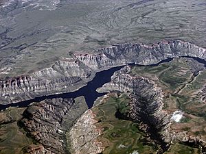
The dam is located about 45 miles (72 km) southeast of Billings, Montana. It sits in Bighorn Canyon. This is where the Bighorn River cuts through the Bighorn Range.
Bighorn Lake is the large reservoir behind the dam. It can hold a lot of water, about 1,381,189 acre-feet (1.703672×10⁹ m3). When the lake is full, it covers about 17,300 acres (70 km2). The lake stretches over 70 miles (110 km) upstream. It is long and narrow, except near Kane, Wyoming, where it gets wider. Many smaller rivers and creeks also flow into Bighorn Lake.
Making Electricity
The dam has a power plant at its base. This plant can produce 250 megawatts (MW) of electricity. It has four large Francis turbines. Each turbine can power a 62,500 kilowatt (KW) generator. The water falls about 495 feet (151 m) to spin these turbines.
The power plant started working in 1966, before the dam was fully finished. It is used to meet peaking power demand. This means it produces more electricity when people need it most. Because of this, the amount of water released can change a lot during the day.
The Yellowtail Afterbay Dam, located 2.2 miles (3.5 km) downstream, helps with this. It stores water released from the main dam. Then, it releases a steady flow into the Bighorn River.
Spillway for Floods
The Yellowtail Dam has a special tunnel called a spillway. It is on the left side of the dam. This spillway can release a lot of floodwater, up to 92,000 cubic feet per second (2,600 m3/s). Two large radial gates control the water flow. The dam also has other outlet works that can release water.
In 1967, there was a lot of melting snow in the Bighorn River area. This caused the lake to rise to very high levels. The dam's spillway was opened for 20 days. However, there was a problem with the spillway's design. The fast-moving water damaged the concrete, creating a huge hole. This damage was later fixed. The repairs at Yellowtail Dam helped engineers learn how to fix similar problems at other large dams.
Fun Activities at Yellowtail Dam

The Yellowtail Dam has changed the Bighorn River below it. The dam releases cooler water from the bottom of Bighorn Lake. This has created one of the best wild trout fishing spots in the United States. This fishing area is over 110 miles (180 km) long.
The dam has also changed the river's natural environment. It stops sediments from flowing downstream. These sediments used to create islands and sandbars. But the cold, fast water and many nutrients make it a perfect home for trout. Trout caught here are usually 14 inches (36 cm) long. The biggest rainbow trout caught was 29 inches (74 cm) long and weighed 16-pound (7.3 kg).
Recently, there has been a debate between Montana and Wyoming. Almost two-thirds of Bighorn Lake is in Wyoming. Wyoming wants to keep more water in the lake for boating and water-skiing. Montana wants more water released for the trout fishing downstream.
Because of a long drought, less water has been released from the dam. This has hurt the trout population. It has also caused the fishing business to decline. Low water levels in the lake have also reduced boating in Wyoming. To help solve this, the government has agreed to keep the lake higher. They also promise to release at least 1,500 cubic feet per second (42 m3/s) of water below the dam.
 | Laphonza Butler |
 | Daisy Bates |
 | Elizabeth Piper Ensley |


