Zorn (river) facts for kids
Quick facts for kids Zorn |
|
| River | |
|
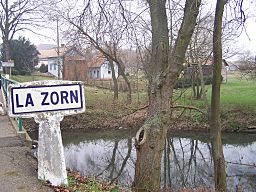
The Zorn near Waltenheim-sur-Zorn.
|
|
| Country | |
|---|---|
| Region | Grand Est |
| Departments | Moselle, Bas-Rhin |
| Municipalities | Brumath, Saverne |
| Tributaries | |
| - left | Zinsel du Sud |
| - right | Mossel |
| Medium city | Saverne |
| Source | Rocher de Mutzig |
| - location | Vosgues mountains, Walscheid, Moselle, France |
| - elevation | 830 m (2,723 ft) |
| - coordinates | 48°33′54″N 7°13′21″E / 48.56500°N 7.22250°E |
| Confluence | Moder |
| - location | Rohrwiller, Bas-Rhin, France |
| - elevation | 124 m (407 ft) |
| - coordinates | 48°45′07″N 7°54′57″E / 48.75194°N 7.91583°E |
| Length | 96.7 km (60 mi) |
| Basin | 757 km² (292 sq mi) |
| Discharge | for Hœrdt |
| - average | 7.41 m³/s (262 cu ft/s) |
The Zorn is a cool river located in the northeastern part of France. It's like a smaller helper river, also known as a tributary, that flows into a bigger river called the Moder.
Contents
About the Zorn River
The Zorn river is quite long, stretching for about 96.7 kilometers (that's about 60 miles!). It also has a large area of land that drains into it, called a drainage basin, which covers about 757 square kilometers (or 292 square miles). Think of a drainage basin as all the land where rain and snow melt will eventually flow into that river.
How Much Water Flows?
The amount of water flowing in the Zorn river is measured by its average yearly discharge. This is basically how much volume of water passes a certain point in the river each second. At a place called Hœrdt in Bas-Rhin, the Zorn river typically carries about 7.41 cubic meters of water every second. That's a lot of water!
Where the Zorn Begins and Ends
The Zorn river actually has an interesting start! It begins high up in the Vosges mountains in a French area called Walscheid, which is in the Moselle department. At first, it's known as the Yellow Zorn (or Zorn Jaune in French). It starts at a high point, about 830 meters (or 2,723 foots) above sea level.
The Yellow Zorn then meets up with another smaller river, the White Zorn (Zorn Blanche in French). When these two rivers join together, it's called a confluence. After this meeting, the river officially becomes known simply as the Zorn. This happens at an altitude of about 295 meters (or 968 foots).
From there, the Zorn river first flows towards the north, then makes a turn to the east. In its final section, it flows towards the northeast. The Zorn river travels through the Grand Est region of France, passing through two different departments, Moselle and Bas-Rhin, and goes through 91 different towns or communes.
Finally, the Zorn river reaches its end when it flows into the Moder river in a town called Rohrwiller, which is also in the Bas-Rhin department.
Main Helper Rivers
The Zorn river has a few important helper rivers, or tributaries, that add water to it along its journey:
- On its left side, it gets water from the Zinsel du Sud, which is about 30.9 kilometers long.
- On its right side, it gets water from the Mossel, which is about 21.2 kilometers long.
Gallery
Related pages
 | Frances Mary Albrier |
 | Whitney Young |
 | Muhammad Ali |


