
Écréhous facts for kids
|
Native name:
Les Écréhous, Êcrého
|
|
|---|---|

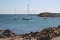
Aerial view of the Ecrehos.
|
|
| Geography | |
| Location | English Channel |
| Coordinates | 49°16′59″N 1°55′59″W / 49.283°N 1.933°W |
| Major islands | Maîtr'Île La Marmotchiéthe Lé Bliantch'Île |
| Administration | |
|
Jersey
|
|
| Parish | Saint Martin, Jersey |
| Demographics | |
| Population | 0 |
| Official name: Les Écréhous & Les Dirouilles, Jersey | |
| Designated: | 2 February 2005 |
| Reference #: | 1455 |
The Écréhous (pronounced Ek-ray-hoo, or Êcrého in Jèrriais) are a small group of islands and rocks. They are located about 9.6 kilometers (6 miles) northeast of Jersey and 12.8 kilometers (8 miles) from France. These islands belong to the Bailiwick of Jersey. They are managed by the Parish of St. Martin.
| Top - 0-9 A B C D E F G H I J K L M N O P Q R S T U V W X Y Z |
What Does the Name Écréhous Mean?
The name 'Ecrehos' comes from the Norse language. The word "sker" means a stony bank or reef. The second part, "hou," means island. You can find "hou" in other island names like Jethou and Lihou. The Écréhous are actually part of a larger group of islands. This group includes Les Dirouilles and Les Pierres de Lecq.
Exploring the Islets of Écréhous
The Écréhous group has several small islands, called islets. The most important ones are:
- Maîtr'Île
- La Marmotchiéthe (also known as 'La Marmotière' in French)
- Lé Bliantch'Île (also known as La Blanche Île in French)
Other smaller islets include:
- Les D'mies
- La Grand' Naithe
- L'Etchièrviéthe
- Lé Fou
- La Froutchie
Most of these islets disappear under the water at high tide. Only the three largest ones stay above water. No one lives on the islands permanently, and there is no fresh water. Over time, the islands have become smaller due to erosion. Maîtr'Île, the biggest islet, is about 300 meters (0.19 miles) long. You can find a few small huts on the larger islets. Fishermen use some of these huts. Others are used for holidays. There is also one official building, a customs house, on La Marmotchiéthe.
A Glimpse into Écréhous History

Thousands of years ago, during the last Ice Age, the sea level was much lower. At that time, the Écréhous were high ground. They were part of a large plain that connected Europe with southern England.
Who Owned the Écréhous Islands?
In 933, the Écréhous and other Channel Islands became part of the Duchy of Normandy. This was before William, Duke of Normandy conquered England in 1066. The islands stayed with Normandy until 1204. That year, Philip Augustus conquered mainland Normandy.
Later, in 1259, Henry III showed respect to the French king for the Channel Islands. In 1360, Edward III gave up his claims to the French crown. But he kept various territories for England, including these islands.
The Old Chapel and Priory
In 1203, John, Duke of Normandy gave the Écréhous to the Abbey of Val-Richer. He wanted them to build a church there. The chapel was about 3.1 meters (10 feet 3 inches) wide and 5 meters (16 feet 6 inches) long. The monks' living area was an extension of the chapel. In 1309, records show that a prior (a monk in charge) lived there. He lived with one other monk and a servant. They also lit a navigation light every night to guide ships.
In 1413, these types of foreign priories were closed down. The monks went back to Val-Richer. Their church and priory on La Maîtr'Île eventually became ruins.
How Were the Islands Used?
In the 1600s, the Écréhous were used by people involved in illegal trade. Records from the 1690s show that lead and gunpowder were often smuggled through the islands. These goods were usually headed for St Malô.
Sometimes, to control voting in Jersey, citizens were taken to the islands. They would stay there until after the voting had finished.
The Kings of the Écréhous
Even though the islands are mostly empty today, some people lived there for a long time in the past. This was because there was more plant life back then. Two unusual people lived on the Écréhous for many years. They called themselves Le Roi des Écréhous (The King of the Écréhous). They even claimed that they owned the islands. One of them, Philippe Pinel, lived on Bliantch'Île from 1848 to 1898. He even exchanged gifts with Queen Victoria!
Settling the Island Dispute
In the 1800s and early 1900s, both Britain and France showed their control over the islands. They would put up flags and buoys. The British government often told the French government that it wanted to officially decide who owned the islands.
In 1950, France took the United Kingdom to the International Court of Justice (ICJ). They wanted the court to decide if the Minquiers and Écréhous belonged to France or Britain. French fishermen used the waters around the islands. However, Jersey had been managing the islands in various ways. In a court case called the Minquiers and Ecrehos case, the ICJ looked at all the historical evidence. On November 17, 1953, the court decided that the islands belonged to Jersey.
Écréhous on Money
La Marmotchiéthe, one of the islets, is shown on the 2010 issue Jersey 50 pound note.
Protecting the Islands
In 2005, the government of Jersey named the Écréhous a Ramsar site. This means it is a wetland of international importance. This gives the islands special protection and recognition. A plan for how to manage the area is still being developed. In 2010, there was a public discussion about how Jersey manages its Ramsar areas. However, the results of this discussion were not made public.
Sailing to the Écréhous
It can be tricky to sail into the islands. But it is possible to visit them at any tide level. The main way to enter is from the southwest.
Gallery
-
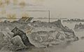
19th century illustration
-
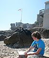
Maîtr'Île Flag Mast 2008
-
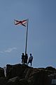
Maîtr'Île Flag Mast 2008
-
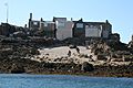
Maîtr'Île from the South
-
Looking South from Maîtr'Île


See also
 In Spanish: Les Écréhous para niños
