
Ada Township, Michigan facts for kids
Quick facts for kids
Ada Township, Michigan
|
|
|---|---|

Unincorporated community of Ada
|
|

Location within Kent County (red) and an administered portion of the Forest Hills CDP (pink)
|
|

Ada Township, Michigan
Location in Michigan

Ada Township, Michigan
Location in the United States
|
|
| Country | United States |
| State | Michigan |
| County | Kent |
| Organized | 1838 |
| Area | |
| • Total | 37.11 sq mi (96.11 km2) |
| • Land | 36.04 sq mi (93.34 km2) |
| • Water | 1.07 sq mi (2.75 km2) |
| Elevation | 758 ft (231 m) |
| Population
(2020)
|
|
| • Total | 14,388 |
| • Density | 387.71/sq mi (149.703/km2) |
| Time zone | UTC-5 (Eastern (EST)) |
| • Summer (DST) | UTC-4 (EDT) |
| ZIP Codes | |
| Area code(s) | 616 |
| FIPS code | 26-081-00240 |
| GNIS feature ID | 1625798 |
Ada Township (pronounced AY-duh) is a community in Kent County, Michigan, in the United States. In 2020, about 14,388 people lived there.
Ada Township is part of the larger Grand Rapids metropolitan area. It is located about 3 miles (4.8 km) east of the city of Grand Rapids. The township is also home to the main offices of Alticor and its well-known company, Amway.
Contents
Communities in Ada Township
Ada Township has a few different communities within its borders. These places help make up the larger township area.
Ada Village: The Heart of the Township
Ada, also known as Ada Village, is a small community inside the township. It is located on M-21, about 12 miles (19 km) east of Grand Rapids. Ada Village has its own post office. Most of the township uses the 49301 ZIP Code from this post office.
Ada was first settled around 1821. A man named Rix Robinson built a trading post there. He traded furs with the local Ottawa people. Robinson bought the first piece of land in 1833. A small town grew along the Thornapple River. A post office opened in 1837. Both the township and the village were named after Ada Smith. She was the daughter of the first postmaster.
Forest Hills: A Large Statistical Area
Forest Hills is another community in Ada Township. It is mostly used for counting people for statistics. This area covers a large part of the township. Forest Hills is also the largest and most populated statistical area in Michigan.
History of Ada Township
The land that is now Ada Township was once a village of the Grand River Band of Ottawa people. Their leader was Nebawnaygezhick.
Early Settlers and Trade
In the early 1800s, Rix Robinson was the first permanent European-American settler in Kent County. He married Sebequay, who was the sister of Nebawnaygezhick. In 1821, Robinson bought a trading post. It was located where the Grand and Thornapple rivers meet. He bought it for John Jacob Astor's American Fur Company.
For a while, land north of the Grand River could not be bought by European-American settlers. This changed after the United States signed a treaty in 1836. After the treaty, Robinson bought many acres of land. He wanted the Ottawa people to continue living there.
Founding of Ada
Lucius Lyon was another early settler. He visited Robinson's settlement in 1826. Lyon believed the land would become very valuable. So, he bought large areas from other early settlers. He helped develop the land, including building a saw mill. Both Lyon and Robinson are seen as the founders of Ada.
The township was officially organized in 1838. Some records say Robinson was the first leader. Other records say Sydney Smith was the first leader. Robinson became the leader later. The village was named after Sydney Smith's daughter, Ada Smith. She was the first non-Native American child born in the village.
Ada Covered Bridge
The Ada Covered Bridge was built across the Thornapple River in 1867. This bridge is very special. It is listed on the National Register of Historic Places. It is one of only a few covered bridges still standing in Michigan.
Geography of Ada Township
Ada Township covers about 37.11 square miles (96.11 square kilometers). Most of this area is land. About 1.06 square miles (2.75 square kilometers) is water.
The Grand River and the Thornapple River both flow through the township.
Main Roads
 M-21 (Fulton Street) is a major road. It runs from west to east through the southern part of the township.
Population Information
In 2020, Ada Township had a population of 14,388 people. Most residents were White (86.3%). Other groups included Asian (4.6%), Black or African American (0.3%), and Native American (0.1%). About 5.9% of the population were from two or more races. People of Hispanic or Latino background made up 5.0% of the population.
Education in Ada Township
Most students in Ada Township go to schools in the Forest Hills Public Schools district. A smaller part of the township, in the northeast, is served by Lowell Area Schools.
Two high schools are located in Ada Township:
- Forest Hills Central High School
- Forest Hills Eastern High School
There is also a part-time Japanese school called the Grand Rapids Supplemental School. It holds its classes at Forest Hills Central High School.
Notable People from Ada Township
Many interesting people have lived in or are connected to Ada Township. Here are a few:
- Kreigh Collins (1908–1974) – a cartoonist
- Dick DeVos (born 1955) – a businessman
- Helen DeVos (1927–2017) – a businesswoman
- Richard DeVos (1926–2018) – he helped start Amway and owned the Orlando Magic basketball team
- Kevin Grady (born 1986) – a college football player
- Adam Grinwis (born 1992) – a professional soccer player
- Lauren Kozal (born 2000) – a professional soccer player
- Kirk O'Bee (born 1977) – a professional road racing cyclist
- Steve Pestka (born 1951) – a politician
- Rix Robinson (1789–1875) – the first settler of Kent County, a pioneer, and fur trader
- Jay Van Andel (1924–2004) – he also helped start Amway
- Kathleen Weathers – a well-known ecologist
Images for kids
-
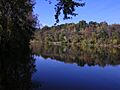
Grand River passing through the township
-
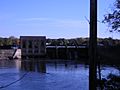
Dam along the Thornapple River


See also
 In Spanish: Municipio de Ada (Míchigan) para niños
