Alpaca Peak facts for kids
Quick facts for kids Alpaca Peak |
|
|---|---|

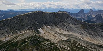
Alpaca Peak seen from Vicuna Peak
|
|
| Highest point | |
| Elevation | 2,083 m (6,834 ft) |
| Prominence | 213 m (699 ft) |
| Parent peak | Vicuna Peak (2126 m) |
| Listing | Mountains of British Columbia |
| Geography | |
| Location | British Columbia, Canada |
| Parent range | North Cascades |
| Topo map | NTS 92H/11 |
| Type of rock | granite |
| Climbing | |
| First ascent | 1965 by Philip Kubik, Ed Zenger |
| Easiest route | Southeast Ridge |
Alpaca Peak is a tall mountain in British Columbia, Canada. It stands about 2,083 meters (6,834 feet) high. This mountain is part of the North Cascades mountain range. It's located about 8 kilometers (5 miles) northwest of Coquihalla Summit. The water from the peak flows into the East Anderson River to the west and the Coldwater River to the east. Alpaca Peak was named after the alpaca animal. This name was chosen by Philip Kubik, who was part of the first group to climb the mountain in 1965. Many nearby peaks also have names of ungulates (hoofed animals). The name "Alpaca Peak" became official on March 23, 1976.
Contents
How Alpaca Peak Was Formed
The North Cascades mountains, including Alpaca Peak, were formed over millions of years. This process began about 50 million years ago.
Earth's Plates and Mountain Building
The Earth's surface is made of huge pieces called plates. The North American Plate slowly moved over the Pacific Plate. This movement caused a lot of volcanic activity. Small pieces of the Earth's crust, called terranes, also came together. This helped create the rugged landscape of the North Cascades.
Ice Ages and Valleys
About two million years ago, during the Pleistocene period, huge sheets of ice called glaciers covered the land. These glaciers moved forward and backward many times. As they moved, they carved out the land. This is why many river valleys in the area have a "U" shape. The combination of land pushing up (called uplift) and cracks in the Earth's crust (called faulting) along with the glaciers created the tall peaks and deep valleys we see today.
Climate Around Alpaca Peak
Alpaca Peak is in a marine west coast climate zone. This means it has mild, wet winters and cool, drier summers.
Weather Patterns
Most of the weather comes from the Pacific Ocean. Weather systems travel east towards the Cascade Range. When they hit the mountains, the air is forced to rise. This process, called Orographic lift, makes the air cool down. As it cools, it drops its moisture as rain or snow. Because of this, the Cascade Mountains get a lot of rain and especially heavy snowfall in winter.
Temperatures and Best Time to Visit
Winter temperatures can be very cold, sometimes dropping below −20 °C (or −4 °F). With the wind, it can feel even colder. The best time to climb Alpaca Peak is usually from July through September. The weather is more stable and pleasant during these months.
Climbing Routes on Alpaca Peak
There are several established ways to climb Alpaca Peak. Here are some of the known routes:
- Southeast Ridge - This is a class 2 difficulty route.
- Northwest Ridge - This route is rated class 3. It was first climbed in 1965.
- Ricker Route - This route is rated class 5. It was first climbed in 1984.
- Heiberg Route - This route is also rated class 5. It was first climbed in 1984.
- Purple People Eaters (East Face) - This route is rated class 5.8. It was first climbed in 1994.
- Al-Pika Slabs - This route is rated class 5.8. It was first climbed in 2004.
 | Kyle Baker |
 | Joseph Yoakum |
 | Laura Wheeler Waring |
 | Henry Ossawa Tanner |


