
Ambert facts for kids
Quick facts for kids
Ambert
|
||
|---|---|---|
|
Subprefecture and commune
|
||

Town hall (originally the grain market)
|
||
|
||

Ambert
Location in France

Ambert
Location in Auvergne-Rhône-Alpes
|
||
| Country | France | |
| Region | Auvergne-Rhône-Alpes | |
| Department | Puy-de-Dôme | |
| Arrondissement | Ambert | |
| Canton | Ambert | |
| Intercommunality | Ambert Livradois Forez | |
| Area
1
|
60.48 km2 (23.35 sq mi) | |
| Population
(2014)
|
6,794 | |
| • Density | 112.335/km2 (290.95/sq mi) | |
| Time zone | UTC+01:00 (CET) | |
| • Summer (DST) | UTC+02:00 (CEST) | |
| INSEE/Postal code |
63003 /63600
|
|
| Elevation | 514–1,365 m (1,686–4,478 ft) (avg. 527 m or 1,729 ft) |
|
| Website | www.ville-ambert.fr | |
| 1 French Land Register data, which excludes lakes, ponds, glaciers > 1 km2 (0.386 sq mi or 247 acres) and river estuaries. | ||
.svg)
Ambert is a small town in central-southern France. It's known as a commune, which is like a local government area. Ambert is located in the Puy-de-Dôme department, which is a bit like a county or province. It's also part of the Auvergne-Rhône-Alpes region, a larger area of France.
Ambert is an important town because it's a "subprefecture." This means it's the main town for a smaller area called an arrondissement, which helps with local government.
Contents
Where is Ambert?
Ambert is in the southeast part of the Puy-de-Dôme department. It's about 37 kilometers (23 miles) south of Thiers. It's also 39 kilometers (24 miles) east of Issoire and 57 kilometers (35 miles) southeast of Clermont-Ferrand.
The town sits in a flat area called the plain of Ambert. It's surrounded by mountains. To the east, you'll find the Monts du Forez, and to the west, the Monts du Livradois. The Dore River flows through the town. This river is a smaller stream that eventually flows into the larger Allier River.
Ambert covers an area of about 60.5 square kilometers (23.4 square miles). The average height above sea level in the area is 940 meters (3,080 feet). Right at the town hall, the height is about 560 meters (1,840 feet).

Ambert is surrounded by several other communes (towns or villages). These include La Forie to the north and northeast, Saint-Martin-des-Olmes to the east and southeast, Saint-Ferréol-des-Côtes to the south, southwest, and west, and Thiolières to the northwest.
Ambert's Weather
Ambert has a type of weather called an Oceanic climate (Cfb). This means it has mild summers and no dry season. It's similar to the climate you might find in parts of Western Europe.
People of Ambert
The people who live in Ambert are called Ambertois (for men) and Ambertoises (for women) in French.
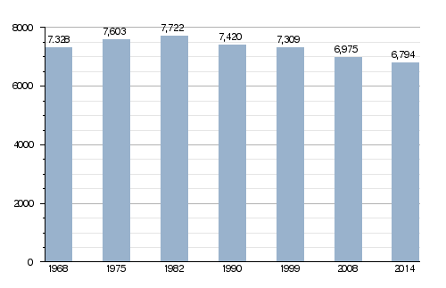
Ambert has a population of 6,794 people. This means there are about 112 people living in each square kilometer (290 people per square mile) of the town's area. This is called the population density.
How Ambert's Population Has Changed
How Ambert is Governed
Ambert is a subprefecture of the Puy-de-Dôme department. This means it's an important administrative center. It's also the main town for the arrondissement of Ambert.
Additionally, Ambert is the main town (called chef-lieu in French) of the canton of Ambert. A canton is a group of several communes that work together. This canton includes 30 different communes and had 18,178 people living there in 2014.
Ambert is also part of a larger group of communes called Ambert Livradois Forez. This group helps manage services for all the towns in the area.
Sister Cities
Ambert has special friendships with other cities around the world. These are called "sister cities" or "twinned cities." It means they share cultural events and learn from each other. Ambert is twinned with:
- Annweiler, Germany, since 1988.
- Saitama, Japan, since 1989.
- Gorgonzola, Italy, since 2002.
Gallery
-
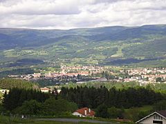
A view of Ambert.
-
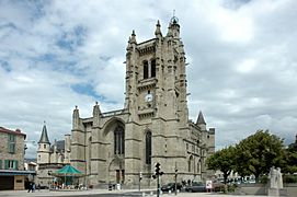
The Saint Jean church in Ambert.
-
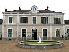
The Train station of Ambert.
-
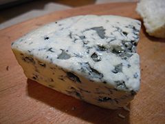
Fourme d'Ambert blue cheese, a famous product from the region.


Related pages
See also
 In Spanish: Ambert para niños
