Amphitheater Mountain (Washington) facts for kids
Quick facts for kids Amphitheater Mountain |
|
|---|---|

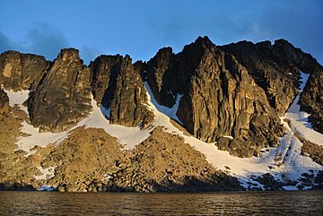
Amphitheater Mountain from Upper Cathedral Lake at sunset.
|
|
| Highest point | |
| Elevation | 8,358 ft (2,548 m) |
| Prominence | 758 ft (231 m) |
| Geography | |
| Location |
|
| Parent range | Okanogan Range North Cascades Cascade Range |
| Topo map | USGS Remmel Mountain |
| Type of rock | Granite |
| Climbing | |
| First ascent | 1901 by Calkins, Smith |
| Easiest route | Scrambling class 3 |
Amphitheater Mountain is a large mountain in Okanogan County, Washington state. It stands about 8,358 feet (2,547 meters) tall. This mountain is part of the Okanogan Range, which is a smaller part of the bigger North Cascades and Cascade Range mountain chains.
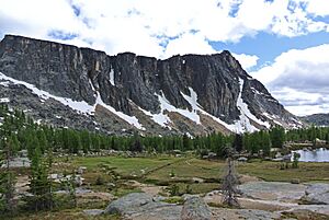
Amphitheater Mountain is located on the eastern side of the Cascade crest. It is found within the Pasayten Wilderness, an area managed by the Okanogan National Forest. The mountain is quite spread out and has several smaller peaks. These include the South Peak (8,269 feet/2,520 meters), West Peak (8,252 feet/2,515 meters), and North Peak (8,200 feet/2,499 meters). The closest taller mountain is Cathedral Peak, which is less than a mile (0.95 miles or 1.5 kilometers) to the north. The Pacific Northwest Trail passes by the northern side of Amphitheater Mountain as it goes through Cathedral Pass. Water from Amphitheater Mountain flows west into Cathedral Fork or east into Cathedral Creek.
Mountain Weather
Most of the weather in this area starts over the Pacific Ocean. These weather systems, called weather fronts, move northeast towards the Cascade Mountains. When these fronts reach the North Cascades, the tall mountains force the air to rise. As the air goes higher, it cools down and drops its moisture as rain or snow onto the Cascades. This process is called Orographic lift.
Because of this, the western side of the North Cascades gets a lot more rain and snow than the eastern side. This is especially true during the winter months. In winter, the weather is usually cloudy. However, in summer, high-pressure systems often form over the Pacific Ocean. These systems bring clear skies, so there is usually little to no cloud cover during the summer months.
How the Mountain Was Formed
The North Cascades region has some of the roughest land in the Cascade Range. You can see jagged peaks, tall spires, long ridges, and deep valleys carved by glaciers. These different landforms and the big changes in height across the Cascade Range were created by geological events that happened millions of years ago. These events also led to the different climates we see today.
The story of how the Cascade Mountains formed began millions of years ago, during a time called the late Eocene Epoch. At that time, the North American Plate (a huge piece of Earth's outer layer) was slowly moving over the Pacific Plate. This movement caused many periods of volcanic activity, where molten rock erupted from the Earth. Also, small pieces of the Earth's crust, called terranes, crashed into North America. These collisions helped build the North Cascades about 50 million years ago.
Later, during the Pleistocene period, which started over two million years ago, huge sheets of ice called glaciers repeatedly moved across the land. As they moved, they scraped and shaped the landscape, leaving behind piles of rock debris. The river valleys in this area have a "U" shape. This unique shape is a direct result of these recent glaciers carving them out. The combination of the land being pushed upwards (called uplift) and cracks forming in the Earth's crust (called faulting), along with the work of glaciers, are the main reasons why the North Cascades has such tall peaks and deep valleys.
Climbing Routes
Amphitheater Mountain is a popular spot for rock climbing. There are several established routes that climbers use to reach the top. These routes have different difficulty levels, often described using the Yosemite Decimal System (YDS), which tells climbers how challenging a route is.
Here are some of the known climbing routes on Amphitheater Mountain:
- Pilgrimage to Mecca - class 5.9 - This route has 4 sections, called pitches.
- Finger of Fatwa - class 5.11c - This route has 5 pitches.
- North Ridge - class 5.5 - This route has 5 pitches.
- Middle Finger Buttress, Left Side - class 5.10b - This route has 4 pitches.
- Middle Finger Buttress, Right Side - class 5.9 - This route has 7 pitches.
 | Claudette Colvin |
 | Myrlie Evers-Williams |
 | Alberta Odell Jones |


