
Amriswil facts for kids
Quick facts for kids
Amriswil
|
||
|---|---|---|

Village Hagenwil
|
||
|
||

Amriswil
Location in Switzerland

Amriswil
Location in Canton of Thurgau
|
||
| Country | Switzerland | |
| Canton | Thurgau | |
| District | Amriswil | |
| Area | ||
| • Total | 19.02 km2 (7.34 sq mi) | |
| Elevation
(evang.-protestant Church)
|
450 m (1,480 ft) | |
| Population
(Dec 2020 )
|
||
| • Total | 14,211 | |
| • Density | 747.16/km2 (1,935.1/sq mi) | |
| Demonym(s) | German: Amriswiler(in) | |
| Postal code |
8580 Amriswil, 8580 Biessenhofen, 8580 Hagenwil b. Amriswil, 8581 Schocherswil, 8587 Oberaach
|
|
| Localities | Mühlebach, Hagenwil, Biessenhofen, Oberaach, Nideraach, Schocherswil, Auenhofen | |
| Surrounded by | Egnach, Erlen, Hefenhofen, Muolen (SG), Salmsach, Sommeri, Zihlschlacht-Sitterdorf | |

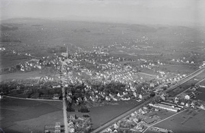
Amriswil (also known as Amerschwiil in a local German dialect) is a town and a municipality in Arbon District in the canton of Thurgau, Switzerland. It is located near Lake Constance.
The main language spoken in Amriswil is a local form of Swiss German. However, the official language is Swiss Standard German.
Contents
History of Amriswil

Amriswil was first mentioned in the year 799. Back then, it was called Amalgeriswilare. During the Middle Ages, Amriswil was part of a fief (land given by a lord in exchange for loyalty). This land belonged to a Bishop.
In the 15th century, the Helmsdorf family ruled in a nearby area called Eppishausen. Later, in the 17th century, the village of Amriswil was sold to Adam Tschudi. In 1665, a hospital in Amriswil was sold to the city of St. Gallen.
The city of Bürglen (which was controlled by St. Gallen) gained legal control over Amriswil. This situation lasted until 1798.
Churches and Religion
Around the mid-1300s, a chapel dedicated to Mary was built in Amriswil. It was part of the parish of Sommeri. After the Protestant Reformation in 1529, most people in Sommeri returned to the old Catholic faith.
However, the people of Amriswil stayed with the Protestant faith. Their chapel was then given to the Protestants. By 1710, a Protestant pastor lived in Amriswil. The town and Sommeri shared a common parish.
In the 19th century, many people moved to Amriswil, changing the religious mix. A large Protestant church was built in Amriswil in 1891. In 1911, the Catholic parish of Amriswil became separate from Sommeri. A new Catholic Church of St. Stephen was opened in 1939.
Growth and Industry
Until about 1830, Amriswil was a quiet village. People mainly farmed and grew grapes for wine. Things started to change when cattle farming was introduced in 1833. A monthly market began in 1840, and a dairy opened in 1852.
A big change happened with the start of large-scale weaving and a knitting factory in 1849. The opening of the Northeastern Railway in 1855 also helped the town grow. A new area developed between the town square and the train station.
Amriswil became an industrial center, especially known for its textile factories. Companies like Sallmann, Laib, and Tuchschmid were very important. Other companies made clothes and shoes.
The town grew so fast that it had problems with water supply. This was fixed in 1952 when water from Lake Constance was brought in.
Many people moved to Amriswil, especially from Italy. The number of foreign residents grew from 7% in 1870 to 29% in 1910. Several smaller villages joined Amriswil, including Hemmerswil in 1925 and Mühlebach in 1932.
New jobs were created in construction, trade, hotels, banks, and services. The textile industry was important until the 1980s when many factories closed. By 1990, Amriswil had a more balanced economy. It had about 90 farms and 3,300 jobs in manufacturing and services. Almost half of these jobs were in the service sector.
Geography of Amriswil
Amriswil covers an area of about 19 square kilometers (7.3 square miles). A large part of this land, about 67.6%, is used for farming. Forests cover about 13% of the area.
About 19.1% of Amriswil is covered by buildings and roads. A very small part, about 0.2%, includes rivers or lakes.
The town is located in the Arbon District. It sits where the roads from Winterthur to Arbon and from Constance to St. Gallen meet. Amriswil includes the main village and smaller settlements called hamlets. These hamlets are Biessenhofen, Oberaach, Schocherswil, and Räuchlisberg.
People and Population

Amriswil has a population of about 13,000 people. In 2008, about 26.4% of the people living in Amriswil were from other countries. Over ten years (1997–2007), the population grew by 3.6%.
Most people in Amriswil speak German (83.2%). Italian is the second most common language (4.5%), followed by Albanian (4.4%).
In 2008, there were slightly more women (51%) than men (49%) living in Amriswil. The population of Swiss citizens decreased slightly, while the number of foreign residents increased. Overall, the population grew by 1.8% in 2008.
Age Groups
Looking at the age of people in Amriswil in 2009:
- About 10.1% of the population are children aged 0-9.
- About 12.9% are teenagers aged 10-19.
- About 15.3% are young adults aged 20-29.
- About 11.9% are aged 30-39.
- About 15.6% are aged 40-49.
- About 13.3% are aged 50-59.
- About 9.2% are aged 60-69.
- About 6.8% are aged 70-79.
- About 4.1% are aged 80-89.
- About 0.8% are 90 years old or older.
Housing and Politics
In 2000, there were 4,604 households in Amriswil, with about 2.4 people living in each. Most buildings were single-family homes.
In the 2007 federal election, the most popular political party was the SVP. They received 40.9% of the votes.
Historical Population
Here's how Amriswil's population has grown over time:
| year | population |
|---|---|
| 1679 | 139 |
| 1850 | 492 |
| 1880 | 1,533 |
| 1910 | 3,322 |
| 1941 | 5,377 |
| 1970 | 7,601 |
| 1980 | 9,013 |
| 1990 | 10,426 |
Important Heritage Sites

Amriswil has some important historical places. The Bohlenständerhaus Schrofen, the Sallmann Carriage Collection, and Hagenwil Castle are listed as Swiss heritage sites of national significance. This means they are very important cultural treasures for the country. The village of Hagenwil bei Amriswil is also recognized as an important Swiss heritage site.
Economy
In 2007, the unemployment rate in Amriswil was 2.45%. This means a small percentage of people who wanted to work could not find jobs.
The economy of Amriswil is divided into three main parts:
- Primary sector: This includes farming and agriculture. In 2005, about 248 people worked in this sector.
- Secondary sector: This involves manufacturing and industry. About 1,764 people worked in factories and businesses that make things.
- Tertiary sector: This is the service sector, including jobs in shops, hotels, banks, and other services. About 2,622 people worked in this sector.
In 2000, about 40.8% of Amriswil residents worked outside the municipality. However, 2,080 people came into Amriswil for work. Most people (48.8%) used a private car to get to work, while 9.5% used public transport.
Religion

Based on the 2000 census:
- About 36.0% of the population were Roman Catholic.
- About 36.0% belonged to the Swiss Reformed Church (Protestant).
- Smaller groups included the Orthodox Church (3.50%) and other Christian churches (3.97%).
- About 9.99% of the population were Islamic.
- About 5.20% of people did not belong to any church, or were agnostic or atheist.
Transport
Amriswil is located on the railway line that connects Winterthur and Romanshorn. The town has two train stations: Amriswil and Oberaach, which are part of the St. Gallen S-Bahn network.
Education
In Amriswil, about 62.2% of adults (aged 25-64) have completed either non-mandatory upper secondary education or higher education, like university.
Amriswil has its own primary and secondary school district. In the 2008/2009 school year, there were 1,474 students in total.
- Kindergarten: There were 320 children in kindergarten.
- Primary School: There were 458 children in lower primary and 478 in upper primary.
- Secondary School: Students are divided into different levels based on their performance. There were 280 teenagers in advanced classes and 240 in standard classes. A small number of students were in special or remedial classes.
Amriswil also has a library called Bibliothek-Ludothek. In 2008, it had 17,897 books and other media. It loaned out 82,856 items that year. The library was open 238 days a year, for an average of 17 hours per week.
Notable people
- Hans Mueller (1900 in Amriswil - 1965) – A physicist and professor who created the Mueller calculus.
- Marianne Straub OBE (1909 in Amriswil – 1994) – A famous textile designer in Britain.
- Gottfried Weilenmann (1920 in Amriswil – 2018) – A Swiss professional cyclist.
- Elwyn Friedrich (1933 in Amriswil – 2012) – A Swiss ice hockey player who competed in the 1964 Winter Olympics.
See also
 In Spanish: Amriswil para niños
