
Anadyr (town) facts for kids
Quick facts for kids Anadyr (English)Анадырь (Russian) Кагыргын / Въэӈын (Chukchi) |
|
|---|---|
| - Town - | |
 |
|
.png) |
|
|
|
|
| Administrative status | |
| Country | Russia |
| Federal subject | Chukotka Autonomous Okrug |
| Administratively subordinated to | Town of okrug significance of Anadyr |
| Municipal status | |
| Urban okrug | Anadyr Urban Okrug |
| Head | Andrey Shchegolkov |
| Representative body | Council of Deputies |
| Statistics | |
| Area | 20 km2 (7.7 sq mi) |
| Time zone | MAGT (UTC+12:00) |
| Founded | 1889 |
| Town status since | 1965 |
| Postal code(s) | 689000, 689700 |
| Dialing code(s) | +7 42722 |
Anadyr (Russian: Ана́дырь) is an important port town in Russia. It is the main city of Chukotka Autonomous Okrug. You can find it at the mouth of the Anadyr River, on a piece of land sticking out into Anadyrsky Liman. Anadyr is the easternmost town in Russia. Other places further east, like Provideniya and Uelen, are not considered towns.
Contents
History of Anadyr
How Anadyr Got Its Name
The name Anadyr is very old, even though the town itself is just over a century old. The name comes from the Yukaghir word "any-an", which means "river".
When explorer Semyon Dezhnev met the Yukaghir people in this area, the local name changed to "Onandyr". Later, it became "Anadyrsk", which was the name of a fort further up the Anadyr River. The current town's name comes from this old fort.
Early Settlements and the Town's Beginning
In the early 1800s, Pyotr Baranov set up a trading post near where Anadyr is today. The local Chukchi settled around it, forming a village called Vyon in 1830.
The town we know today was started in 1889 by L. F. Grinevetsky. He arrived in the Anadyrsky Liman on July 9, 1889. The first building was finished just twelve days later. Since it was the name-day of Tsaritsa Maria Feodorovna, the town was first named Mariinsk. Because there was already another town named Mariinsk in Russia, the name was quickly changed to Novo–Mariinsk.
Changes in the Early 1900s
In the early 1900s, there were many changes in Russia. In Anadyr, a group of people tried to bring new ideas and change how things were run. They wanted to help the local people and change the way businesses worked.
However, their efforts faced challenges. Some local merchants and other groups resisted these changes. There were struggles for control in the town. Eventually, the new ideas took hold, and the town began to be governed differently.
In 1923, Novo–Mariinsk was officially renamed Anadyr.
Anadyr During World War II
During World War II, an airfield was built in Anadyr. This airfield was part of the Alaska-Siberian (ALSIB) air route. It was used to fly American planes to the Eastern Front to help in the war effort.
Anadyr Becomes a Town
Anadyr officially became a town in 1965. Around that time, its population was about 5,600 people.
For more than ten years, a special dog sled race called the Hope Sled Dog Race took place between Anadyr and Nome, Alaska.
Modern Discoveries
In 2011, a group of scientists led by Paul Steinhardt came to Anadyr. They were on their way to the Koryak Mountains to look for something called quasicrystals. These are special materials with unique atomic structures.
The scientists found three natural quasicrystals from their trip. They discovered that these quasicrystals were inside a meteorite that hit Earth about 15,000 years ago. This was an exciting discovery for science!
Geography and Climate

Where Anadyr Is Located
Anadyr is located on the tip of a large piece of land that sticks out into the water. To the north is the mouth of the Anadyr River. To the east is the wide part of the river, called the Anadyrsky Liman, which flows into the Gulf of Anadyr.
The town itself is built on a gentle slope rising from the sea. Across the Anadyr River, you can see mountains. To the west of the town, there are large, flat areas of tundra.
Anadyr is at a similar northern latitude as cities like Fairbanks, Alaska and Oulu, Finland. Usually, not many people live in places so far north.
Anadyr's Climate
Anadyr has a subarctic climate. This means winters are very long and cold. Summers are pleasant but short. January is the coldest month, with an average temperature of about -22.1 degrees Celsius. July is the warmest, with an average of about 12.1 degrees Celsius. It's rare for temperatures to go above 25 degrees Celsius.
The lowest temperature ever recorded was -46.8 degrees Celsius in January 1913. The highest was 30 degrees Celsius in July 1956. The weather in Anadyr can change quickly. Strong storms often come from the Anadyrsky Liman and the Bering Sea. In autumn, strong winds can cause flooding. May is usually the driest month, and January is the wettest.
| Climate data for Anadyr (Shakhtyorsky) weather station (WMO identifier: 25563), 64m amsl, 1991–2020, extremes 1889–present | |||||||||||||
|---|---|---|---|---|---|---|---|---|---|---|---|---|---|
| Month | Jan | Feb | Mar | Apr | May | Jun | Jul | Aug | Sep | Oct | Nov | Dec | Year |
| Record high °C (°F) | 5.8 (42.4) |
2.7 (36.9) |
3.0 (37.4) |
7.1 (44.8) |
19.3 (66.7) |
26.5 (79.7) |
30.0 (86.0) |
26.6 (79.9) |
19.8 (67.6) |
15.6 (60.1) |
4.6 (40.3) |
4.3 (39.7) |
30.0 (86.0) |
| Mean maximum °C (°F) | −2.8 (27.0) |
−3.7 (25.3) |
−2.2 (28.0) |
0.6 (33.1) |
9.7 (49.5) |
21.2 (70.2) |
23.7 (74.7) |
21.1 (70.0) |
14.7 (58.5) |
5.7 (42.3) |
2.0 (35.6) |
−1.1 (30.0) |
24.7 (76.5) |
| Mean daily maximum °C (°F) | −18.5 (−1.3) |
−17.4 (0.7) |
−14.6 (5.7) |
−8.2 (17.2) |
2.0 (35.6) |
11.6 (52.9) |
16.1 (61.0) |
14.1 (57.4) |
8.3 (46.9) |
−1.1 (30.0) |
−8.3 (17.1) |
−15.8 (3.6) |
−2.6 (27.3) |
| Daily mean °C (°F) | −22.1 (−7.8) |
−21.1 (−6.0) |
−18.4 (−1.1) |
−12.0 (10.4) |
−1.2 (29.8) |
7.2 (45.0) |
12.1 (53.8) |
10.5 (50.9) |
5.3 (41.5) |
−3.6 (25.5) |
−11.5 (11.3) |
−19.2 (−2.6) |
−6.2 (20.8) |
| Mean daily minimum °C (°F) | −25.7 (−14.3) |
−24.7 (−12.5) |
−21.8 (−7.2) |
−15.6 (3.9) |
−3.9 (25.0) |
4.0 (39.2) |
9.0 (48.2) |
7.7 (45.9) |
2.7 (36.9) |
−5.9 (21.4) |
−14.6 (5.7) |
−22.6 (−8.7) |
−9.3 (15.3) |
| Mean minimum °C (°F) | −37.7 (−35.9) |
−36.8 (−34.2) |
−33.2 (−27.8) |
−27.0 (−16.6) |
−13.9 (7.0) |
−1.8 (28.8) |
4.4 (39.9) |
2.0 (35.6) |
−3.7 (25.3) |
−16.6 (2.1) |
−26.4 (−15.5) |
−35.2 (−31.4) |
−39.6 (−39.3) |
| Record low °C (°F) | −46.8 (−52.2) |
−44.7 (−48.5) |
−42.1 (−43.8) |
−39.6 (−39.3) |
−28.2 (−18.8) |
−7.6 (18.3) |
−1.2 (29.8) |
−4.3 (24.3) |
−11.8 (10.8) |
−28.2 (−18.8) |
−38.8 (−37.8) |
−45.2 (−49.4) |
−46.8 (−52.2) |
| Average precipitation mm (inches) | 40 (1.6) |
44 (1.7) |
38 (1.5) |
23 (0.9) |
13 (0.5) |
16 (0.6) |
36 (1.4) |
45 (1.8) |
32 (1.3) |
29 (1.1) |
36 (1.4) |
33 (1.3) |
385 (15.2) |
| Average extreme snow depth cm (inches) | 16 (6.3) |
17 (6.7) |
19 (7.5) |
19 (7.5) |
8 (3.1) |
0 (0) |
0 (0) |
0 (0) |
0 (0) |
3 (1.2) |
6 (2.4) |
11 (4.3) |
19 (7.5) |
| Average rainy days | 0.2 | 0.2 | 0.2 | 1 | 9 | 15 | 17 | 19 | 17 | 6 | 2 | 1 | 88 |
| Average snowy days | 18 | 18 | 15 | 17 | 16 | 2 | 0.1 | 0.3 | 5 | 19 | 19 | 18 | 147 |
| Average relative humidity (%) | 82 | 81 | 81 | 82 | 84 | 78 | 79 | 81 | 80 | 84 | 84 | 82 | 82 |
| Average dew point °C (°F) | −25 (−13) |
−24 (−11) |
−22 (−8) |
−14 (7) |
−3 (27) |
3 (37) |
8 (46) |
7 (45) |
2 (36) |
−6 (21) |
−15 (5) |
−22 (−8) |
−9 (15) |
| Mean monthly sunshine hours | 29 | 101 | 197 | 249 | 245 | 279 | 257 | 186 | 138 | 105 | 47 | 15 | 1,848 |
| Source 1: Погода и климат | |||||||||||||
| Source 2: NOAA (sun, 1961–1990)
Source 3: Time and Date (dewpoints, between 1985–2015) Infoclimat |
|||||||||||||
Anadyr's Government and Status
Anadyr is the main administrative center for Chukotka Autonomous Okrug. This means it's where the regional government is located.
It also serves as the administrative center for Anadyrsky District. However, Anadyr itself is not part of that district. It's considered a "town of okrug significance," which means it has its own special administrative status, similar to a district.
For local government, the town of Anadyr, along with the nearby village of Tavayvaam, forms the Anadyr Urban Okrug.
Population Growth
Anadyr's population has changed over the years. Here's how it has grown:
| 1926 | 1939 | 1959 | 1970 | 1979 | 1989 | 2002 | 2010 | 2021 |
|---|---|---|---|---|---|---|---|---|
| 224 | 3,344 | 5,859 | 7,703 | 12,241 | 17,094 | 11,038 | 13,045 | 13,202 |
Transportation in Anadyr

Anadyr is a very important sea port on the Bering Sea. It connects to many other major seaports in the Russian Far East.
Air Travel
Anadyr has an airport called Ugolny Airport. It serves flights to big and small cities in the Russian Far East. You can fly to places like Khabarovsk, Vladivostok, and even Moscow. There are also special charter flights to Nome, Alaska in the United States offered by Bering Air.
The airport is on the other side of the Anadyrsky Liman (the wide river mouth). From January to May, when the water is frozen, people can travel to the airport using an ice road. In the summer, a ferry takes passengers across the Anadyr River to the airport. But during spring and autumn, when the ice is melting and floating, the only way to get to the airport is by helicopter.
Roads
While there are roads connecting Anadyr to the nearby village of Tavayvaam, the town is not connected by road to any other major settlements.
However, construction of the Anadyr Highway began in 2012. This highway will connect Anadyr to Magadan, which is about 1,800 kilometers (1,100 miles) away.
Notable People from Anadyr
- Roman Abramovich, a well-known businessman and former owner of Chelsea FC. He was also the former Governor of Chukotka Autonomous Okrug.
- Diomid Dzyuban, a former bishop of Anadyr.
- Marina Demeshchenko, an indie-pop singer.
Twin Towns
Anadyr is twinned with:
Images for kids
-
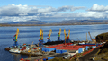
View of the Anadyr port
-
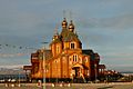
Trinity Church
-
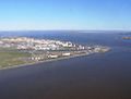
View of Anadyr from a helicopter
-
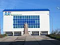
Anadyr Child Creativity Palace, with the Lenin statue in front of the building


See also
 In Spanish: Anádyr para niños
