
Andersonstown facts for kids
Quick facts for kids Andersonstown
|
|
|---|---|
 Andersonstown Road, 2007 |
|
| Population | (2001 census) |
| OS grid reference | NW4190927083 |
| Irish grid reference | O003360 |
| District | |
| County | |
| Country | Northern Ireland |
| Sovereign state | United Kingdom |
| Post town | BELFAST |
| Postcode district | BT11 |
| Dialling code | 028 |
| EU Parliament | Northern Ireland |
| UK Parliament |
|
| NI Assembly |
|
Andersonstown, often called Andytown, is a neighborhood in west Belfast, Northern Ireland. It's located at the base of the Black Mountain and Divis Mountain. This area has many different types of homes. It is mostly a working-class community. Many people here have strong Irish Catholic and Irish nationalist traditions. The district covers the area between Shaws Road, Glen Road, and Andersonstown Road.
Contents
Exploring Andersonstown's Past
Andersonstown is located in County Antrim. Long ago, it was part of a larger area called the Barony of Belfast Upper. It was also part of the parish of Shankill. The specific piece of land was known as Ballydownfine. This name comes from Irish words meaning "townland of the fort of Finn."
The area was once called Whitesidetown. This was after the family who owned the land. However, they lost their land because they supported a group called the Society of United Irishmen. This group wanted big changes in Ireland. So, the name of the area changed. In 1832, it was a small village with only eleven families. Some of these families were named Anderson. These Anderson families likely came from Scotland.
Most of what is now Andersonstown was a farm called 'Maryburne'. A family named Collins owned it. After a family disagreement, the land was sold. Andersonstown then grew very quickly in the 1950s and 1960s. The local housing authority built many new houses. These homes were for people who had to move from the lower Falls Road area. As more people moved in, new housing estates like Twinbrook and Poleglass were built further from Belfast. The area is bordered by Andersonstown Road to the south, Glen Road to the north, and Shaw's Road to the west.
The Black Mountain area is divided into six smaller parts for elections. These parts are Shaw's Road, Andersonstown, Colin Glen, Turf Lodge, Falls Park, and Beechmount. The parts named Andersonstown and Shaw's Road cover the main Andersonstown area.
Key Places in Andersonstown

In 2008, the Andersonstown area had about 5,064 people living there.
There are five Catholic churches in the neighborhood. These include St Agnes', St. Michael's, St Teresa's, St Matthias', and Holy Spirit Church.
Andersonstown also has several schools. Some of these are Holy Child Primary School and De La Salle College. St Genevieve's High School for girls is located where Stewartstown and Andersonstown Roads meet. St Mary's Christian Brothers' Grammar School and the All Saints College are on the upper Glen Road.
Sports in Andersonstown
Casement Park is a very important sports stadium in Andersonstown. It is the main stadium for Antrim GAA. GAA stands for Gaelic Athletic Association. This group promotes traditional Irish sports.
Donegal Celtic F.C. is a football club. They play their home games at Donegal Celtic Park. This stadium is on Suffolk Road, near Andersonstown. In 1990, a game was supposed to be played there. It was an Irish Cup game between Donegal Celtic and Linfield F.C.. Police moved the game to a different stadium. This was because they were worried about trouble. Even with the move, some problems still happened.
On the Glen Road, there is a path leading into the mountains. This area is called Glen Road Heights. It is home to two sports clubs. These are Sport & Leisure Swifts F.C. and St. Teresa's GAC. Their sports grounds are very close to each other.
Culture and Media in the Area
The local newspaper for Andersonstown is called the Andersonstown News. This newspaper often shares an Irish Republican point of view. It is made by the Belfast Media Group. This group also publishes newspapers in other parts of the city. The Andersonstown News comes out on Mondays and Thursdays.
The neighborhood is also featured in a novel. The book is called Titanic Town by Mary Costello. There was also a movie made from the book. It was adapted by Anne Devlin.
Neighboring Communities
Andersonstown is the main area beyond the Falls Road. It is next to several other areas. These areas together form the Upper Falls District Electoral Area.
To the south of Andersonstown Road is the main district of Ladybrook. This area is roughly bordered by Finaghy Road North. Finaghy Road North leads to the Finaghy area and the Upper Lisburn Road. The M1 motorway is also nearby. The Riverdale Estate was built in the 1940s. It provided homes for both people who bought and rented. This area is bordered by Andersonstown Road and the M1 Motorway.
Ladybrook is next to the Blacks Road area. This part is mostly a loyalist community. The rest of the area is mostly republican. This loyalist area is also known as Suffolk. It is home to about 800 Protestants. The Suffolk Community Forum represents them. This group works with Catholic neighbors in the Suffolk Lenadoon Interface Group.
Because Suffolk is so close to republican areas, there is an interface area. This is a place where different communities meet. It is at the junction with the Stewartstown Road. The Andersonstown Road joins here with Shaw's Road. This interface is near the Woodbourne Police Service of Northern Ireland barracks. These barracks are like a police station. There have been many clashes between young people from the different areas here.
The barracks are on the site of the old Woodbourne House Hotel. This hotel was destroyed early in a period of conflict known as the Troubles.
North of the Stewartstown Road is the Lenadoon area. It is bordered by Shaw's Road. Lenadoon has a public park that was updated in 2000. Lenadoon used to have people from different communities living together. However, after street violence in the early 1970s, many Protestants moved away. The area then became almost entirely Catholic. The Suffolk Road area is further west. It is home to the Donegal Celtic football club. Suffolk includes Blacks Road. This can sometimes lead to disagreements between groups of young people.
The area around Suffolk Road was once seen as part of the Protestant Suffolk area. A Church of Ireland church stands on the corner of the Stewartstown Road there. Lenadoon Avenue forms an interface. In 1972, this street saw violence. This violence ended a short period of peace. Some houses were empty on the street. A Catholic family moved into one of them. This move had been approved by the Northern Ireland Housing Executive. This attracted a crowd of people. They attacked the houses. Soon, the British Army arrived.
A tense situation lasted for several days. Then, another Catholic family tried to move into the street. The army, worried about a riot, blocked their vehicle. People who supported the republican side became very angry. Soldiers used rubber bullets, tear gas, and water cannons. The republican groups said the army and a government official, William Whitelaw, had broken earlier agreements. They felt the army was favoring the loyalists. By that evening, the republican group announced they would no longer keep the peace. A gun battle with the army followed.
The Glengoland area is next to Colin Glen Forest Park. It is between the Stewartstown Road and the Glen Road. This area used to be the western edge of the Belfast City Council area. After the Suffolk Road junction, Stewartstown Road entered the area controlled by Lisburn City Council. This road led towards Poleglass and nearby areas. However, local government in Northern Ireland was changed. This happened before the 2014 local elections. Because of these changes, these areas are now part of an expanded Belfast City Council.
Images for kids
-
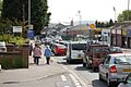
Andersonstown Road, 2007
-
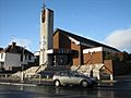
St Agnes' Church, Andersonstown
