Andrews County, Texas facts for kids
Quick facts for kids
Andrews County
|
|
|---|---|

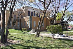
Andrews County Courthouse in Andrews
|
|

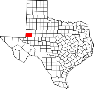
Location within the U.S. state of Texas
|
|
 Texas's location within the U.S. |
|
| Country | |
| State | |
| Founded | 1910 |
| Named for | Richard Andrews |
| Seat | Andrews |
| Largest city | Andrews |
| Area | |
| • Total | 1,501 sq mi (3,890 km2) |
| • Land | 1,501 sq mi (3,890 km2) |
| • Water | 0.4 sq mi (1 km2) 0.02% |
| Population
(2020)
|
|
| • Total | 18,610 |
| • Density | 12.398/sq mi (4.7870/km2) |
| Time zone | UTC−6 (Central) |
| • Summer (DST) | UTC−5 (CDT) |
| Congressional district | 19th |
Andrews County is a county located in the western part of Texas, a state in the United States. Its main town and county seat is Andrews.
As of the 2020 census, about 18,610 people live in Andrews County. The county is also part of the Andrews Micropolitan Statistical Area, which means it's a small city area with strong economic ties.
Andrews County was officially created on August 21, 1876, from a larger area called Tom Green County. It was fully organized in 1910. The county is named after Richard Andrews, who was a soldier during the Texas Revolution.
Contents
History of Andrews County
Andrews County, like the rest of Texas, has been part of several different governments throughout history:
- It was part of New Spain starting in 1521.
- Then it became part of an independent Mexico in 1821.
- In 1836, it joined the Republic of Texas.
- Texas became a state of the United States of America in 1845.
- During the American Civil War, from 1861, it was part of the Confederate States of America.
- After the Civil War ended in 1865, Texas was required to rejoin the United States.
- For about nine years, Texas was governed by temporary leaders during a period called Reconstruction.
- In 1870, the people of Texas were allowed to vote on a new constitution and fully rejoin the United States, with their own elected representatives.
In 1876, the Texas Legislature (the state's law-making group) created a new constitution and officially established Andrews County.
Geography
Andrews County covers about 1,501 square miles. Most of this area is land, with only a tiny bit (about 0.4 square miles) being water. The county has many small, temporary lakes called playa lakes. The two biggest ones are Baird Lake and Shafter Lake.
In the western part of Andrews County, near the border with New Mexico, there's a special site. A company called Waste Control Specialists (WCS) operates a large area where they handle certain types of waste. They received a license in 2009 to safely dispose of special materials. This site started operating in 2012 and has two areas for waste. One is managed by the State of Texas, and the other by the United States federal government. The company provides jobs for about 130 people in the area.
For many years, there has been a discussion about the exact border between Texas and New Mexico in this area. The original border was supposed to be a straight line, but a survey done in 1859 placed it a few miles too far west. This means some areas, including the waste site, which are west of the intended line, are currently considered part of Texas. Even though New Mexico once tried to claim this land, it is now taxed and governed by Andrews County and the State of Texas.
Major highways
 US 385
 SH 115
 SH 176
 Loop 1910
 FM 181
 FM 1218
 FM 1967
 FM 1788
 FM 2371
Adjacent counties
- Gaines County (north)
- Martin County (east)
- Midland County (southeast)
- Ector County (south)
- Winkler County (southwest)
- Lea County, New Mexico (west/Mountain Time Zone)
People of Andrews County (Demographics)
| Historical population | |||
|---|---|---|---|
| Census | Pop. | %± | |
| 1890 | 24 | — | |
| 1900 | 87 | 262.5% | |
| 1910 | 975 | 1,020.7% | |
| 1920 | 350 | −64.1% | |
| 1930 | 736 | 110.3% | |
| 1940 | 1,277 | 73.5% | |
| 1950 | 5,002 | 291.7% | |
| 1960 | 13,450 | 168.9% | |
| 1970 | 10,372 | −22.9% | |
| 1980 | 13,323 | 28.5% | |
| 1990 | 14,338 | 7.6% | |
| 2000 | 13,004 | −9.3% | |
| 2010 | 14,786 | 13.7% | |
| 2020 | 18,610 | 25.9% | |
| U.S. Decennial Census 1850–2010 2010 2020 |
|||
The population of Andrews County has changed a lot over the years. In 1890, only 24 people lived there, but by 2020, the population grew to 18,610.
Here's a look at the different groups of people living in Andrews County:
| Race / Ethnicity (NH = Non-Hispanic) | Pop 2000 | Pop 2010 | Pop 2020 | % 2000 | % 2010 | % 2020 |
|---|---|---|---|---|---|---|
| White alone (NH) | 7,322 | 7,083 | 7,405 | 56.31% | 47.90% | 39.79% |
| Black or African American alone (NH) | 195 | 199 | 192 | 1.50% | 1.35% | 1.03% |
| Native American or Alaska Native alone (NH) | 64 | 95 | 96 | 0.49% | 0.64% | 0.52% |
| Asian alone (NH) | 88 | 85 | 102 | 0.68% | 0.57% | 0.55% |
| Pacific Islander alone (NH) | 2 | 1 | 0 | 0.02% | 0.01% | 0.00% |
| Other race alone (NH) | 13 | 17 | 49 | 0.10% | 0.11% | 0.26% |
| Mixed race or Multiracial (NH) | 118 | 111 | 366 | 0.91% | 0.75% | 1.97% |
| Hispanic or Latino (any race) | 5,202 | 7,195 | 10,400 | 40.00% | 48.66% | 55.88% |
| Total | 13,004 | 14,786 | 18,610 | 100.00% | 100.00% | 100.00% |
In 2010, about 79.5% of the people in Andrews County were White, and 48.7% were Hispanic or Latino (who can be of any race).
Education
All students in Andrews County attend schools within the Andrews Independent School District.
The entire county is also served by Odessa College, which offers higher education opportunities.
Media
Andrews County has a weekly newspaper. There are also local radio stations, KACT AM and KACT-FM, and other nearby stations. People in the county can also tune into various radio and TV stations from the larger cities of Midland and Odessa.
Communities
City
- Andrews (county seat)
Census-designated place
Unincorporated communities
- Florey
- Frankel City
Ghost towns
- Coyote Corner
- Fasken
- Old Place Windmills
- Shafter Lake
- Sixteen Corner Windmill
- Waldon Place Windmill
See also
 In Spanish: Condado de Andrews para niños
 | Kyle Baker |
 | Joseph Yoakum |
 | Laura Wheeler Waring |
 | Henry Ossawa Tanner |

