Angora Lakes facts for kids
Quick facts for kids Upper Angora Lake |
|
|---|---|
 |
|
| Location | El Dorado County, California |
| Coordinates | 38°51′51″N 120°04′00″W / 38.86417°N 120.06667°W |
| Type | glacial tarn |
| Basin countries | United States |
| Max. length | 0.5 mi (0.80 km) |
| Max. width | 0.5 mi (0.80 km) |
| Shore length1 | 1 mi (1.6 km) |
| Surface elevation | 7,450 ft (2,270 m) |
| Settlements | Meyers, California South Lake Tahoe, California Stateline, Nevada |
| 1 Shore length is not a well-defined measure. | |
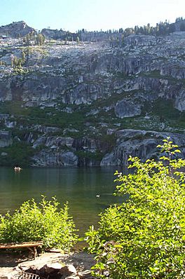
The Angora Lakes are two small, clear freshwater lakes located in the Sierra Nevada mountains. They are part of the Lake Tahoe area in California. These lakes are about 1,200 feet (366 meters) higher than Fallen Leaf Lake and Lake Tahoe.
The lakes are home to the Angora Lakes Resort. This is a small place for outdoor fun during the summer. The lakes got their name from a group of Angora goats that used to live and eat grass in the area.
Contents
Getting to Angora Lakes
Reaching the Angora Lakes is an adventure! From Highway 89, you can take the Fallen Leaf Lake Road turnoff. You will drive about 2 miles (3.2 km) on this road.
Another way is to take Lake Tahoe Boulevard to Tahoe Mountain Road. Then, turn left and drive up a one-lane road. Look for a dirt road with a sign that says "1214."
This road can be steep in places. It offers amazing views as you climb. The road ends at the Angora Lakes trailhead parking lot. From there, it's about a 1-mile (1.6 km) uphill hike to reach Angora Lake.
Fun Things to Do at Angora Lakes
The road to the lower parking lot is usually open from May 1 to October 1. During this time, you can walk to the Angora Lakes Resort.
At the resort, you'll find a small snack bar. They serve sandwiches, "world famous" lemonade, and ice cream. You can also rent rowboats, kayaks, and paddle boards to enjoy on the water.
Cliff Jumping and Swimming
One exciting activity at the upper lake is cliff jumping. There's a cliff face where people can jump into the water. The highest spot often used is about 60 feet (18 meters) above the lake. Many people enjoy jumping during the summer.
There is also a small beach on the northwestern side of the lake. It has granite sand and is a popular spot for swimming and sunbathing.
Parking Information
Parking at the end of Angora Ridge Road costs money and is limited. On busy summer weekends, the parking lot can fill up quickly. It's best to arrive early. Parking along Angora Ridge Road is not allowed.
The Lake Tahoe area is a popular tourist spot. The main cities nearby are South Lake Tahoe, California and Stateline, Nevada. Other smaller towns include Tahoe City and Kings Beach.
The Angora Fire of 2007
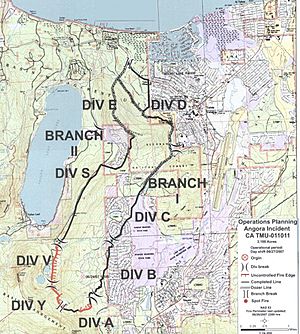
In 2007, a large wildfire called the "Angora Fire" started near the Angora Lakes. It began on Sunday, June 24, around 1:00 PM. The fire spread quickly because of strong winds. It moved through a heavily forested area.
The fire caused a lot of damage to homes in the area. Many houses were destroyed or damaged. About 3,000 people had to leave their homes for safety.
Over 2,100 firefighters worked hard to stop the blaze. They used 145 fire engines and 9 air tankers. The fire burned about 3,100 acres (12.5 square kilometers) of land. For several days, the entire Lake Tahoe area was filled with thick smoke.
The strong winds helped the fire spread at first. But calmer weather later helped firefighters gain control. They were able to contain about 70% of the fire.
It is believed that people caused the fire, as there were no thunderstorms nearby. After the fire, there was concern about ash falling into Lake Tahoe. This ash could make the lake less clear. Leaders promised to help restore the land. This would prevent erosion and keep the ash from harming the lake's famous clarity.
Nearby Mountains
The Angora Lakes area is surrounded by several impressive mountains. Here are some of them:
- Echo Peak (8,895 feet or 2,711.2 meters)
- Angora Peak (8,588 feet or 2,617.6 meters)
- Mount Tallac (9,735 feet or 2,967 meters)
- Ralston Peak (9,235 feet or 2,814.8 meters)
- Pyramid Peak (9,985 feet or 3,043.4 meters)
 | Aaron Henry |
 | T. R. M. Howard |
 | Jesse Jackson |


