Kings Beach, California facts for kids
Quick facts for kids
Kings Beach, California
|
|
|---|---|

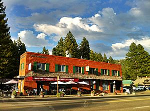
Downtown Kings Beach, 2011
|
|

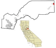
Location in Placer County and the state of California
|
|
| Country | |
| State | |
| County | |
| Area | |
| • Total | 3.439 sq mi (8.908 km2) |
| • Land | 3.439 sq mi (8.908 km2) |
| • Water | 0 sq mi (0 km2) 0% |
| Elevation | 6,444 ft (1,964 m) |
| Population
(2020)
|
|
| • Total | 3,563 |
| • Density | 1,036.06/sq mi (399.98/km2) |
| Time zone | UTC-8 (PST) |
| • Summer (DST) | UTC-7 (PDT) |
| ZIP code |
96143
|
| Area code(s) | 530 |
| FIPS code | 06-38548 |
| GNIS feature ID | 2408481 |
Kings Beach is a community located in Placer County, California, right on the north shore of Lake Tahoe. It is known as a census-designated place (CDP). This means it's an area identified by the U.S. Census Bureau for statistical purposes, but it doesn't have its own official city government. In 2020, about 3,563 people lived in Kings Beach. The town's post office was built in 1937. The area is named after its first postmaster, Joe King.
Contents
Exploring Kings Beach's Location
Kings Beach is situated on the northern edge of Lake Tahoe. This beautiful lake is famous for its clear blue waters. The community is also right on the border with Nevada. It shares a boundary with Crystal Bay, Nevada, to the east.
Roads and Travel in Kings Beach
Two important roads meet in Kings Beach. California State Route 28 starts here, continuing from where Nevada State Route 28 ends in Crystal Bay. Route 28 runs along the shore of Lake Tahoe through Kings Beach.
Another road, California State Route 267, connects Kings Beach to other nearby places. These include Northstar, a popular ski resort, and the town of Truckee. Route 267 also links to Interstate 80, a major highway.
Kings Beach Population and Community Life
Kings Beach is a popular spot for vacations in Northern California. Many of the homes here are used as vacation rentals. This makes the population change a lot between different times of the year.
Population Changes Over Time
| Historical population | ||
|---|---|---|
| Year | Pop. | ±% |
| 2000 | 4,037 | — |
| 2010 | 3,796 | −6.0% |
| 2020 | 3,563 | −6.1% |
| U.S. Decennial Census | ||
The population of Kings Beach has changed over the years. In 2000, there were 4,037 people. By 2010, the population was 3,796. The most recent census in 2020 counted 3,563 residents.
Who Lives in Kings Beach?
At the 2020 census, Kings Beach had a population of 3,563 people. The community is diverse. Many residents identify as White or Hispanic/Latino. There are also people from other racial backgrounds living in Kings Beach.
Because many visitors like to light campfires, fire officials have called Kings Beach a "very high fire hazard severity zone." This means there is a high risk of wildfires. For example, an illegal campfire caused the Angora Fire in 2007, which was a large fire nearby.
Historic Stateline Fire Lookout
In Kings Beach, on a hill above the downtown area, you can find the historic Stateline fire lookout. This spot is very close to the California–Nevada state line. It's also known as the Crystal Bay scenic overlook. You can reach it by taking an easy hiking trail from Crystal Bay, Nevada. From here, you can enjoy amazing panoramic views of Lake Tahoe.
See also
 In Spanish: Kings Beach (California) para niños
 | May Edward Chinn |
 | Rebecca Cole |
 | Alexa Canady |
 | Dorothy Lavinia Brown |


