Antelope, Oregon facts for kids
Quick facts for kids
Antelope, Oregon
|
|
|---|---|
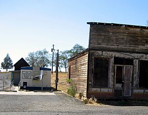
Post office and abandoned building in Antelope
|
|
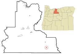
Location in Oregon
|
|
| Country | United States |
| State | Oregon |
| County | Wasco |
| Incorporated | 1901 |
| Area | |
| • Total | 0.46 sq mi (1.19 km2) |
| • Land | 0.46 sq mi (1.19 km2) |
| • Water | 0.00 sq mi (0.00 km2) |
| Elevation | 2,667 ft (813 m) |
| Population
(2020)
|
|
| • Total | 37 |
| • Density | 80.26/sq mi (30.96/km2) |
| Time zone | UTC-8 (Pacific) |
| • Summer (DST) | UTC-7 (Pacific) |
| ZIP code |
97001
|
| Area code(s) | 541 |
| FIPS code | 41-02250 |
| GNIS feature ID | 2409714 |
| Website | cityofantelope.us |
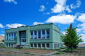
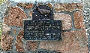
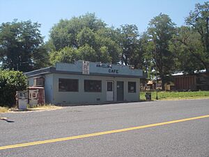
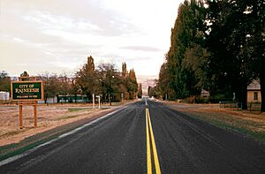
Antelope is a small city in a rural part of Oregon, United States. It's located in Wasco County. In 2020, only 37 people lived there. This city is famous for a unique time in its history. From 1984 to 1986, it was known as Rajneesh. This happened when a large group of people from the Rajneesh movement moved nearby and changed the city's name.
Contents
History of Antelope
The area around Antelope was likely named by early American settlers. They were traveling through the valley with supplies. They saw many pronghorns, which look like antelopes. That's how the name "Antelope Valley" probably came to be.
How Antelope Began
In the mid-1800s, Antelope started as a stop along a wagon road. This road connected The Dalles on the Columbia River to gold mines. These mines were located near Canyon City. Later, this wagon road became known as The Dalles Military Road.
The Antelope post office opened in 1871. The town's population grew a lot around 1900. This was after a railway line was built nearby. The railway made it easier to travel to and from the area. Antelope officially became an incorporated city in 1901.
The Rajneesh Movement and City Name Change
In 1981, a large farming and meditation community called Rajneeshpuram was built near Antelope. It was founded by followers of Bhagwan Shri Rajneesh. Many Rajneesh followers moved into the area. They registered to vote in Antelope. This meant they soon had more voters than the original residents.
Because of this, the Rajneeshees gained control of the town council. On September 18, 1984, the city's name was changed to "Rajneesh."
However, the Rajneesh organization faced many problems. Some of their leaders were found to be involved in illegal activities. The leader, Rajneesh, left the country in 1985. The Rajneesh community then broke apart. On November 6, 1985, the city voted to change its name back to Antelope. The name was officially restored in 1986. The U.S. Postal Service had never even recognized the name change.
After the community collapsed, the land was sold. In 1991, a billionaire named Dennis Washington bought it. Today, this ranch is used by Young Life. It is a Christian youth camp called "Washington Family Ranch." The events of this time were shown in the 2018 Netflix documentary Wild Wild Country.
Geography of Antelope
Antelope is located in north-central Oregon. It sits along Oregon Route 218. This is just north of where it meets Oregon Route 293. By road, the city is about 34 miles (55 km) northeast of Madras. It is also about 143 miles (230 km) east of Portland. Antelope Creek flows near the city. This creek is part of the Deschutes River system.
The city is about 2,654 feet (809 meters) above sea level. The United States Census Bureau says the city covers about 0.48 square miles (1.24 square kilometers). All of this area is land.
Antelope's Climate
Antelope has a climate known as a warm-summer Mediterranean climate. This means it has hot, dry summers and mild, wet winters.
| Climate data for Antelope, Oregon, 1991–2020 normals, extremes 1924–present | |||||||||||||
|---|---|---|---|---|---|---|---|---|---|---|---|---|---|
| Month | Jan | Feb | Mar | Apr | May | Jun | Jul | Aug | Sep | Oct | Nov | Dec | Year |
| Record high °F (°C) | 70 (21) |
72 (22) |
78 (26) |
90 (32) |
98 (37) |
108 (42) |
107 (42) |
109 (43) |
101 (38) |
91 (33) |
76 (24) |
72 (22) |
109 (43) |
| Mean maximum °F (°C) | 57.6 (14.2) |
59.1 (15.1) |
66.1 (18.9) |
75.5 (24.2) |
84.4 (29.1) |
91.7 (33.2) |
98.8 (37.1) |
98.3 (36.8) |
92.6 (33.7) |
79.9 (26.6) |
65.1 (18.4) |
56.0 (13.3) |
100.4 (38.0) |
| Mean daily maximum °F (°C) | 42.9 (6.1) |
46.1 (7.8) |
52.8 (11.6) |
58.7 (14.8) |
68.4 (20.2) |
75.7 (24.3) |
87.3 (30.7) |
86.5 (30.3) |
78.2 (25.7) |
63.5 (17.5) |
49.7 (9.8) |
41.6 (5.3) |
62.6 (17.0) |
| Daily mean °F (°C) | 34.2 (1.2) |
36.2 (2.3) |
41.1 (5.1) |
45.6 (7.6) |
53.6 (12.0) |
60.2 (15.7) |
68.9 (20.5) |
68.3 (20.2) |
61.2 (16.2) |
49.8 (9.9) |
39.5 (4.2) |
32.7 (0.4) |
49.3 (9.6) |
| Mean daily minimum °F (°C) | 25.6 (−3.6) |
26.2 (−3.2) |
29.4 (−1.4) |
32.5 (0.3) |
38.9 (3.8) |
44.6 (7.0) |
50.5 (10.3) |
50.1 (10.1) |
44.1 (6.7) |
36.0 (2.2) |
29.3 (−1.5) |
23.8 (−4.6) |
35.9 (2.2) |
| Mean minimum °F (°C) | 10.1 (−12.2) |
11.2 (−11.6) |
18.6 (−7.4) |
22.3 (−5.4) |
27.1 (−2.7) |
33.8 (1.0) |
40.2 (4.6) |
39.6 (4.2) |
32.3 (0.2) |
22.8 (−5.1) |
14.6 (−9.7) |
8.0 (−13.3) |
0.5 (−17.5) |
| Record low °F (°C) | −27 (−33) |
−22 (−30) |
5 (−15) |
11 (−12) |
13 (−11) |
25 (−4) |
29 (−2) |
30 (−1) |
20 (−7) |
8 (−13) |
−7 (−22) |
−20 (−29) |
−27 (−33) |
| Average precipitation inches (mm) | 1.50 (38) |
1.29 (33) |
1.22 (31) |
1.52 (39) |
1.99 (51) |
1.04 (26) |
0.34 (8.6) |
0.34 (8.6) |
0.50 (13) |
1.23 (31) |
1.76 (45) |
1.81 (46) |
14.54 (370.2) |
| Average snowfall inches (cm) | 2.0 (5.1) |
1.0 (2.5) |
0.7 (1.8) |
1.0 (2.5) |
0.0 (0.0) |
0.0 (0.0) |
0.0 (0.0) |
0.0 (0.0) |
0.0 (0.0) |
0.2 (0.51) |
1.2 (3.0) |
3.6 (9.1) |
9.7 (24.51) |
| Average precipitation days (≥ 0.01 in) | 10.9 | 9.7 | 9.7 | 9.7 | 9.7 | 6.3 | 2.5 | 2.7 | 3.8 | 7.9 | 10.3 | 12.1 | 95.3 |
| Average snowy days (≥ 0.1 in) | 2.0 | 1.6 | 0.6 | 0.2 | 0.0 | 0.0 | 0.0 | 0.0 | 0.0 | 0.1 | 0.9 | 2.4 | 7.8 |
| Source 1: NOAA | |||||||||||||
| Source 2: National Weather Service | |||||||||||||
Antelope's Population
| Historical population | |||
|---|---|---|---|
| Census | Pop. | %± | |
| 1890 | 184 | — | |
| 1900 | 249 | 35.3% | |
| 1910 | 175 | −29.7% | |
| 1920 | 199 | 13.7% | |
| 1930 | 136 | −31.7% | |
| 1940 | 90 | −33.8% | |
| 1950 | 60 | −33.3% | |
| 1960 | 46 | −23.3% | |
| 1970 | 51 | 10.9% | |
| 1980 | 39 | −23.5% | |
| 1990 | 34 | −12.8% | |
| 2000 | 59 | 73.5% | |
| 2010 | 46 | −22.0% | |
| 2020 | 37 | −19.6% | |
| source: | |||
Population in 2010
In 2010, there were 46 people living in Antelope. These people lived in 28 households. There were 10 families. The city had about 96 people per square mile (37 people per square kilometer).
Most of the people (91.3%) were White. There was also 1 Native American person and 1 Asian person. Two people were from two or more races.
About 11% of households had children under 18. About 21% were married couples. Most households (64%) were not families. Many households (61%) had only one person living there. About 46% of households had someone aged 65 or older living alone.
The average age in the city was 62 years old. About 15% of residents were under 18. About 41% were 65 or older. The population was almost evenly split between males (52%) and females (48%).
See also
 In Spanish: Antelope (Oregón) para niños
 | Kyle Baker |
 | Joseph Yoakum |
 | Laura Wheeler Waring |
 | Henry Ossawa Tanner |


